Lima, founded in 1535 as the Ciudad de los Reyes, is the capital and largest city of Peru. It is located in the valleys of the Chillón, Rímac and Lurín Rivers, in the desert zone of the central coastal part of the country, overlooking the Pacific Ocean. The city is considered the political, cultural, financial and commercial center of Peru. Due to its geostrategic importance, the Globalization and World Cities Research Network has categorized it as a "beta" tier city. Jurisdictionally, the metropolis extends mainly within the province of Lima and in a smaller portion, to the west, within the Constitutional Province of Callao, where the seaport and the Jorge Chávez Airport are located. Both provinces have regional autonomy since 2002.

Callao is a Peruvian seaside city and region on the Pacific Ocean in the Lima metropolitan area. Callao is Peru's chief seaport and home to its main airport, Jorge Chávez International Airport. Callao municipality consists of the whole Callao region, which is also coterminous with the province of Callao. Founded in 1537 by the Spaniards, the city has a long naval history as one of the main ports in Latin America and the Pacific, as it was one of vital Spanish towns during the colonial era. Central Callao is about 15 km (9.3 mi) west of the Historic Centre of Lima.
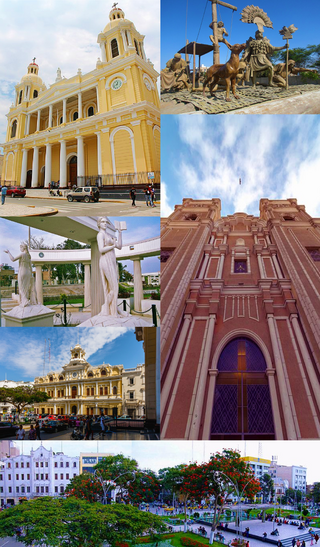
Chiclayo is the principal city and capital of the Lambayeque region and Chiclayo Province in northern Peru. It is located 13 kilometers from the Pacific coast, 208 kilometers from the city of Trujillo and 770 kilometers from the country's capital, Lima. It was founded under the name of "Santa María de los Valles de Chiclayo".
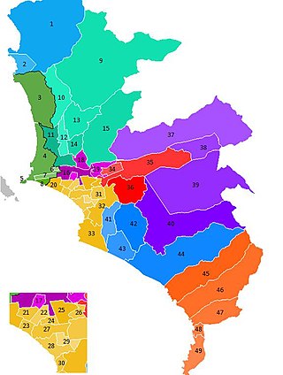
The administrative divisions of Peru have changed from time to time since the nation gained independence from Spain in the early 19th century. The old territorial subdivisions have split or merged due to several reasons, the most common ones being the need for decentralization and population increase, especially in Lima.
Tumbes is a coastal department and region in northwestern Peru bordering Ecuador. Due to the region's location near the Equator it has a warm climate, with beaches that are considered among the finest in Peru. Despite its small area, the region contains a wide variety of ecosystems. It is the smallest department in Peru and its third least populous department after Moquegua and Madre de Dios, but it is also its third most densely populated department, after La Libertad and Lambayeque.

Chorrillos is a district of the Lima Province in Peru and part of the city of Lima. It gets its name from the Spanish word for "trickle of water". The district was founded as San Pedro de los Chorrillos and served as a deluxe beach resort until the late 19th century, when it was almost completely destroyed by Chilean forces during the War of the Pacific.

Lima is a district of Lima Province in Peru. Lima district is the oldest in Lima Province and as such, vestiges of the city's colonial era remain today in the historic centre of Lima, which was declared a UNESCO World Heritage Site in 1988 and contains the foundational area known as Cercado de Lima.
The Lima Metropolitan Area is an area formed by the conurbation of the Peruvian provinces of Lima and Callao. It is the largest of the metropolitan areas of Peru, the seventh largest in the Americas, the fourth largest in Latin America, and among the thirty largest in the world. The conurbation process started to be evident in the 1980s.

La Punta is a district of the Constitutional Province of Callao in Peru, and one of the seven districts that make up the port city of Callao. It is located on a peninsula in the western part of the province and is almost entirely surrounded by the Pacific Ocean, except on its northeastern side, where it is bordered by downtown Callao.

San Martín de Porres (SMP) is a district in Lima, Peru, located in the north area of the city. It is bordered by the Chillón River, marks its natural border with Ventanilla and Puente Piedra on the north; Callao on the west; Los Olivos, Comas on the northeast; Rímac and Independencia districts on the east; the Rímac River marks its natural border with Lima District and Carmen de la Legua Reynoso on the south. It is the second most populated district of Lima metropolitan area and Peru.
Punta Hermosa is one of 43 districts of the Lima Province in Peru. The capital of the district is the village of Punta Hermosa. The district's main attractions are its beaches.

Ventanilla is a district of the Constitutional Province of Callao in Peru, and one of the seven districts that comprise the port city of Callao. Covering more than half of the province's territory, it is Callao's largest district.

Maynas is one of the eight provinces in the Loreto Region in northeastern Peru. Its capital, Iquitos, is also Loreto's regional capital and the largest city in the Peruvian Amazon Rainforest.

Miraflores is a district of the Lima Province in Peru. It is a residential and upscale shopping district south of downtown Lima. It is also one of the wealthiest districts that make up the city of Lima. It has several hotels, restaurants, bars, nightclubs, and department stores. Miraflores is one of the main tourist destinations in Lima.
Santa Rosa is a district of the Lima Province in Peru. Officially established as a district on February 6, 1962. The district's postal code is 38. It limits to the north and the east with the Ancón District, to the west with the Pacific Ocean, to the south with the Ventanilla District.
A Peruvian postal code is a five-digit string that comprises part of a postal address in Peru. Prior to 2011, only the major cities of Lima and Callao used postal codes. However, in February 2011 a nationwide system was implemented which employs a five-digit numeric format. Similar to the postal codes of Mexico, Brazil, Australia, the United States, and elsewhere, postal codes in Peru are strictly numerical, using only numbers.
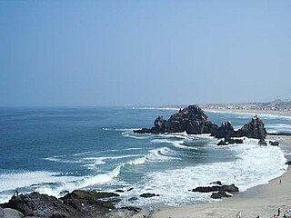
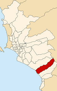
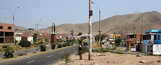
Punta Negra is one of the 43 districts of the Province of Lima. It borders the district of Punta Hermosa to the north, the Province of Huarochirí to the east, the district of San Bartolo to the south, and the Pacific Ocean to the west.

The Integrated Transport System for Lima and Callao is an urban public transportation system that operates in the Lima metropolitan area, made up of the Peruvian cities of Lima and Callao. Its administration is in charge of the Urban Transport Authority (ATU).

Lima Bay, also known as Miraflores Bay, is a bay located of the coast of Lima, Peru. Its shore is located on the central coast of the Lima Province and the southern end of Callao, both part of the metropolitan area of Lima. Administratively it belongs to both Lima and Callao.