
Lima, originally founded as Ciudad de Los Reyes is the capital and largest city of Peru. It is located in the valleys of the Chillón, Rímac and Lurín Rivers, in the desert zone of the central coastal part of the country, overlooking the Pacific Ocean. Together with the seaside city of Callao, it forms a contiguous urban area known as the Lima Metropolitan Area. With a population of more than 9.7 million in its urban area and more than 11 million in its metropolitan area, Lima is one of the largest cities in the Americas.

Pueblos jóvenes is the term used for the shanty towns that surround Lima and other cities of Peru. Many of these towns have developed into districts of Lima such as Comas, Los Olivos and Villa El Salvador.
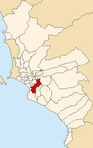
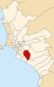
Santiago de Surco, commonly known simply as Surco, is a district of Lima, Peru. It is bordered on the north with the district of Ate Vitarte and La Molina; on the east with San Juan de Miraflores, on the west with San Borja, Surquillo, Miraflores and Barranco, and on the south with Chorrillos.

The Lima Metro is a rapid transit system that serves the area of the cities of Lima and Callao, both of which make up the Lima metropolitan area, currently linking the district of Villa El Salvador in the south of Lima with San Juan de Lurigancho in the northeast of the same city.

Villa El Salvador (VES) is an urban, largely residential coastal district on the outskirts of Lima, Peru. It borders the district of Chorrillos on the east; the Pacific Ocean on the southwest; Lurín on the southeast; Villa María del Triunfo on the east and San Juan de Miraflores on the north.

San Isidro is a district of the Lima Province in Peru. It is located in the west center of the city, it has a few meters of coastline. Officially created on April 24, 1931, San Isidro, along with Orrantia and Country Club districts, was separated from Miraflores.
The Lima Metropolitan Area is an area formed by the conurbation of the Peruvian provinces of Lima and Callao. It is the largest of the metropolitan areas of Peru, the seventh largest in the Americas, the fourth largest in Latin America, and among the thirty largest in the world. The conurbation process started to be evident in the 1980s.

La Molina is a district of the Lima Province in Peru, and one of the upscale districts that comprise the province of Lima. Officially established as a district on February 6, 1962, the current mayor of La Molina is Álvaro Paz de la Barra.

Miraflores is a district of the Lima Province in Peru. It is a residential and upscale shopping district south of downtown Lima. It is also one of the most affluent districts that make up the city of Lima. It has several hotels, restaurants, bars, nightclubs, and department stores. Miraflores is one of the main tourist destinations in Lima.
Ate, also known as Ate-Vitarte, is a district of the Lima Province in Peru. Located in the eastern part of the province, it is one of the districts that comprise the city of Lima.
San Juan de Miraflores is a district of the Lima Province in Peru. It is located in the Cono Sur area of the city of Lima. Is one of the new towns, that have been formed by the massive numbers of people moving from other towns of Metropolitan Lima and from the countryside. During the early 1960s, was mostly a desert area.
Villa María del Triunfo is a district of the Lima Province in Peru. It is located in the Cono Sur area of the city of Lima. It was officially established as a district on December 28, 1961. The current mayor (alcalde) of Villa María del Triunfo is Eloy Chávez Hernández.
A Peruvian postal code is a five-digit string that comprises part of a postal address in Peru. Prior to 2011, only the major cities of Lima and Callao used postal codes. However, in February 2011 a nationwide system was implemented which employs a five-digit numeric format. Similar to the postal codes of Mexico, Brazil, Australia, the United States, and elsewhere, postal codes in Peru are strictly numerical, using only numbers.

The valley of Lurín is a district of the Lima Province in Peru. Known for its archaeological temple of Pachacamac, the Pachacamac Island or "La Ballena", countryside areas, villages, fincas, rural restaurants, nightlife and beaches, it is one of the three valleys of the city of Lima.
The peruvian district of Punta Negra is one of the 43 districts of the Province of Lima. It borders the district of Punta Hermosa to the north, the Province of Huarochirí to the east, the district of San Bartolo to the south, and the Pacific Ocean to the west.

San Bartolo is a district in southern Lima Province in Peru. It is bordered by the Pacific Ocean on the west, the district of Punta Negra on the north, the Huarochirí Province on the east, and the Santa María del Mar District on the south.
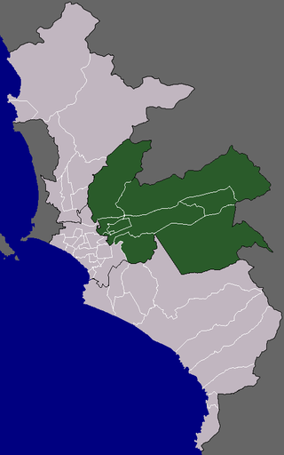
The Cono Este or Lima Este is one of the six areas that make up the Lima Metropolitan Area. It is located in the eastern part of the metropolis hence its name. The socioeconomic levels of its residents are varied. They mainly belong however to the middle class. Wealthier residents can be found in a few districts in this area as many people move to this area to escape the cloudy winters of Lima. During the winter, this is the only area of Lima that is not permanently covered by fog. The most developed areas of this section are certain retirement urbanizations in Lurigancho-Chosica and Chaclacayo. These areas are home to picturesque winter housing developments owned by people seeking to escape the winter fog. Santa Anita presents the highest degree of urban consolidation, while being the smallest district on the area. La Molina is a mainly residential district which gathers people of the high socioeconomic status, it also concentrates commercial activities. The least developed are those of El Agustino which is populated by slum housing, and Cieneguilla, which is mostly unurbanized. The district of Ate has to some extent undergone industrialization with several factories having been built there.

Squatting in Peru is the occupation of unused or derelict buildings or land without the permission of the owner. From the 1940s onwards, land invasions to create shanty towns first called barriadas and later pueblos jóvenes have occurred. At first they were repressed, then the government tolerated them and by 1998 it was estimated 2.5 million inhabitants lived in pueblos jóvenes in the capital Lima. In Lima there are also slum tenements in the centre known as solares or tugurios. A Wall of Shame has been built to separate rich and poor areas of the city. During the COVID-19 pandemic in Peru, an increase in the occupation of UNESCO World Heritage Sites such as Caral and the Nazca Lines was reported.
