Los Olivos District

Last updated
The Olives District
Distrito de los Olivos (Spanish)
Plaza de armas de los olivos ,Lima ,Peru.jpg
Bandera de Los Olivos.png
Escudo de Los Olivos.png
Map of Lima highlighting Los Olivos.PNG
Location of Los Olivos in Lima
Country Flag of Peru.svg  Peru
Region Lima
Province Lima
FoundedApril 6, 1989
Capital Las Palmeras
Subdivisions 1 populated center
Government
   Mayor Felipe Castillo Oliva
(2023–2026)
Area
  Total18.25 km2 (7.05 sq mi)
Elevation
75 m (246 ft)
Population
 (2023) [1]
  Total366,371
Time zone UTC-5 (PET)
UBIGEO 150117
Website munilosolivos.gob.pe

Los Olivos is a district of the Lima Province in Peru. Is a District of the Cono Norte area in the city of Lima.

Contents

History

In the Viceroyalty and early years of the republic, it was part of the great territory of Carabayllo.

In the mid-16th century, when the encomienda system failed, the Lima Cabildo granted land to Nicolás de Ribera in the Chillón Valley and to Francisco de Ampuero in Chuquitanta. By the 17th century, near these properties, the haciendas of El Naranjal, Pro, Infantas, and Aznapuquio were established.

The first efforts to create a new district date back to 1970, when a group of neighbors from El Trébol and Sol de Oro Urbanization came together to form the " Rosa de América" Management Committee. On February 4, 1977, a new committee with greater scope was created.

The district was officially established on April 6, 1989, when it separated from San Martín de Porres.

The main reason for the separation was the abandonment of these residential developments by the Municipality of San Martín de Porres.
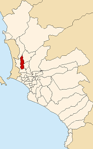
Geography

The district has a total land area of 18.25 km2. Its administrative center is located 75 meters above sea level.

Boundaries

Mayors

Demographics

According to a 2002 estimate by the INEI, the district has 301,226 inhabitants and a population density of 16,505.5 persons/km2. In 1999, there were 53,660 households in the district. Most people living in this district belong to the new middle class.

Most of the heads of households in the district are immigrants, coming predominantly from the north of the country, where those from the regions of Ancash, Cajamarca, La Libertad, Piura and Lambayeque stand out, with those from the first department being more numerous. Many of these immigrants come from the little bourgeoisie.

Economy

Los Olivos is considered by some media as the best developed district of Cono Norte of Lima, due to the large number of services found in the district and the high quality of life (HDI) of the district, in addition to those provided due to the proximity of the large stores and shopping centers of the Independencia and Comas Districts.

Education

Universities

2020 stampede

On 22 August 2020 thirteen people were killed in a while trying to flee an illegal nightclub party in Peru raided by police on Saturday night, officials said. There were approximately 120 people at the Thomas Restobar nightclub in Los Olivos, just north of Lima, when police arrived to the scene. Neighbors had alerted police about the event. Partygoers, upon police arrival, rushed to escape through a single door, according to a statement from the Peru Interior Ministry. No tear gas or weapons were fired. [2] [3]

Related Research Articles

<span class="mw-page-title-main">Lima</span> Capital and largest city of Peru

Lima, founded in 1535 as the Ciudad de los Reyes, is the capital and largest city of Peru. It is located in the valleys of the Chillón, Rímac and Lurín Rivers, in the desert zone of the central coastal part of the country, overlooking the Pacific Ocean. The city is considered the political, cultural, financial and commercial center of Peru. Due to its geostrategic importance, the Globalization and World Cities Research Network has categorized it as a "beta" tier city. Jurisdictionally, the metropolis extends mainly within the province of Lima and in a smaller portion, to the west, within the Constitutional Province of Callao, where the seaport and the Jorge Chávez Airport are located. Both provinces have regional autonomy since 2002.

<span class="mw-page-title-main">Lima metropolitan area</span> Place in Peru

The Lima Metropolitan Area is an area formed by the conurbation of the Peruvian provinces of Lima and Callao. It is the largest of the metropolitan areas of Peru, the seventh largest in the Americas, the fourth largest in Latin America, and among the thirty largest in the world. The conurbation process started to be evident in the 1980s.

<span class="mw-page-title-main">Rímac District</span> District in Lima, Peru

Rímac, known until the 19th century as the neighbourhood of San Lázaro, is a district in the Lima Province, Peru. It lies directly to the north of downtown Lima, to which it is connected by six bridges over the Rímac River. The district also borders the Independencia, San Martín de Porres, and San Juan de Lurigancho districts. Vestiges of Lima's colonial heyday remain today in an area of the Rímac district known as the Historic centre of Lima, which was declared a UNESCO World Heritage Site in 1988. Downtown Rímac District has, like its southern counterpart, its eastern and western sides divided by Jirón Trujillo, which connects to Lima District's Jirón de la Unión through the Puente de Piedra, the oldest bridge in the whole city. Rímac's East side features the Plaza de Acho, the most famous bullfighting arena in South America and one of the most well known in the world.

<span class="mw-page-title-main">San Martín de Porres District</span> District in Lima, Peru

San Martín de Porres (SMP) is a district in Lima, Peru, located in the north area of the city. It is bordered by the Chillón River, marks its natural border with Ventanilla and Puente Piedra on the north; Callao on the west; Los Olivos, Comas on the northeast; Rímac and Independencia districts on the east; the Rímac River marks its natural border with Lima District and Carmen de la Legua Reynoso on the south. It is the second most populated district of Lima metropolitan area and Peru.

<span class="mw-page-title-main">San Juan de Lurigancho</span> District in Lima, Peru

San Juan de Lurigancho (SJL) is a district in Lima, Peru, located in the area known as Cono Este. It is Peru's most populous district, with a current population that may exceed one million.

<span class="mw-page-title-main">Comas District, Lima</span> District in Lima, Peru

The district of Comas is one of the forty-three districts that make up the province of Lima, located in the department of the same name, in Perú. It is located in the north area of the city. It is one of the most populous districts in Lima.

<span class="mw-page-title-main">Independencia District, Lima</span> District in Lima, Peru

Independencia is a district of the Lima Province in Peru. It is located in the north area of the city.

A Peruvian postal code is a five-digit string that comprises part of a postal address in Peru. Prior to 2011, only the major cities of Lima and Callao used postal codes. However, in February 2011 a nationwide system was implemented which employs a five-digit numeric format. Similar to the postal codes of Mexico, Brazil, Australia, the United States, and elsewhere, postal codes in Peru are strictly numerical, using only numbers.

<span class="mw-page-title-main">Carabayllo District</span> District in Lima, Peru

Carabayllo is one of the 43 districts of the province Lima in Peru. It is located in the Cono Norte area of the province and was created district by General José de San Martín in August 4, 1821 at which time it was the only district to occupy the area north of the Rímac River up to the province Canta.

<span class="mw-page-title-main">Cono Norte</span> Sector in Lima, Peru

The Cono Norte is one of the five areas that make up the Lima Metropolitan Area. It is located in the northern part of the metropolis, hence its name. The socioeconomic levels of its residents are varied. The districts of Ancón and Santa Rosa are the popular beach resorts for wealthier residents of Lima. The rest of the population comprises middle class and lower class residents. It is one of the most populated areas of Peru.

<span class="mw-page-title-main">Puente Piedra District</span> District in Lima, Peru

The Peruvian district of Puente Piedra is one of the 43 districts in the Lima Province. It is located in the north of the city.

The Judicial District of Cono Norte is one of the 28 Judicial Districts of the Judicial System of Peru.

The Judicial District of Lima is one of the 28 Judicial Districts of the Judicial System of Peru.

Martin de Porres is a Peruvian Roman Catholic patron saint of mixed-race people and racial harmony, usually depicted holding a black scapular and capuce in iconography.

Events in the year 2020 in Peru.

A crowd crush occurred in the Los Olivos District of Lima, Peru on 22 August 2020, killing at least thirteen and injuring six others. The crush was a result of a raid by the National Police of Peru on the Thomas Restobar nightclub to break up an illegal gathering amid the COVID-19 pandemic in Peru.

<span class="mw-page-title-main">2017 Lima shooting</span> Mass shooting in Lima, Peru

The 2017 Lima shooting was a mass shooting that began on February 17 and ended on February 18, 2017 at the Royal Plaza shopping center, located in a disputed area between the districts of Independencia and San Martín de Porres, and to a lesser extent in a sector of the district of Los Olivos, in northern Lima, Peru. As a result of the event, at least 5 people lost their lives and 10 were injured.

<span class="mw-page-title-main">Túpac Amaru Avenue</span> Avenue in Lima, Peru

Túpac Amaru Avenue, also known as the Highway to Ancón and as the Former Northern Pan-American Highway until 1974, is a major avenue in Lima, Peru. It starts at Caquetá Avenue in Rímac District, travelling northbound for over 40 blocks while crossing San Martín de Porres, Los Olivos, Independencia and Comas districts, until it reaches Trapiche, becoming the Vencedores de Sángrar Highway in Carabayllo District, which connects Lima with Canta.

<span class="mw-page-title-main">Terminal Naranjal</span> Northern terminal of the Metropolitano transit system

Terminal Naranjal is the northern terminal of the Metropolitano bus system in Lima, Peru. Located in a disputed area of the district of Independencia, it is the northern end of the line for the system and its busiest station.

References

  1. "Estadística Poblacional - Ministerio de Salud del Perú". Archived from the original on 2019-04-16. Retrieved 2024-04-28.
  2. de la Quintana, Jimena; Silva, Daniel (23 August 2020). "At least 13 people die in stampede, as police raid club breaking coronavirus restrictions". CNN . Archived from the original on 6 December 2021. Retrieved 23 August 2020.
  3. "13 Die in Peru Disco Stampede After Police Lockdown Raid". Associated Press . 23 August 2020. Archived from the original on 6 December 2021. Retrieved 28 April 2024.

11°58′13″S77°04′26″W / 11.97028°S 77.07389°W / -11.97028; -77.07389