Santa Anita District

Last updated
Saint Anita District
Distrito de Santa Anita (Spanish)
District sign Peru Lima Santa Anita.jpg
BanderaSantaAnita.png
COA Santa Anita District in Lima Province.png
Map of Lima highlighting Santa Anita.PNG
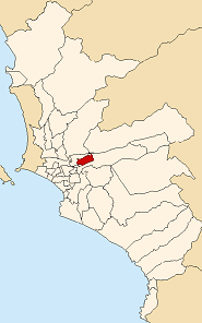
Location of Santa Anita in the Lima province
Country Flag of Peru.svg  Peru
Region Lima
Province Lima
FoundedOctober 25, 1989
Capital Santa Anita
Subdivisions 1 populated center
Government
   Mayor Olimpio Alegría
(2023-2026)
Area
  Total10.69 km2 (4.13 sq mi)
Elevation
195 m (640 ft)
Population
 (2023) [1]
  Total232,739
Time zone UTC-5 (PET)
UBIGEO 150137
Website munisantanita.gob.pe

Santa Anita is a district of the Lima Province in Peru. It is part of city of Lima. Officially established as a district on October 25, 1989, from parts of Ate and El Agustino separated by the Rio Surco, a ditch which went all the way to Santiago de Surco.

Contents

The current mayor ( alcalde ) of Santa Anita is Olimpio Alegría Calderón. The district's postal code is 43. The core sections of Santa Anita are: Santa Anita proper, originally a section of Ate; and Los Ficus and Universal, originally sections of El Agustino. Industrial areas to the east of Santa Anita and Universal mark the boundary with Ate.

Geography

The district has a total land area of 10.69 km2. Its administrative center is located 195 meters above sea level.

Boundaries

Demographics

According to a 2002 estimate by the INEI, the district has 154,359 inhabitants and a population density of 14,439.6 inhabitants/km2. In 1999, there were 27,908 households in the district.

See also

Related Research Articles

<span class="mw-page-title-main">Lima</span> Capital and largest city of Peru

Lima is the capital and largest city of Peru. It is located in the valleys of the Chillón, Rímac and Lurín Rivers, in the desert zone of the central coastal part of the country, overlooking the Pacific Ocean. The city is considered the political, cultural, financial and commercial center of Peru. Due to its geostrategic importance, the Globalization and World Cities Research Network has categorized it as a "beta" tier city. Jurisdictionally, the metropolis extends mainly within the province of Lima and in a smaller portion, to the west, within the Constitutional Province of Callao, where the seaport and the Jorge Chávez Airport are located. Both provinces have regional autonomy since 2002.

<span class="mw-page-title-main">Pueblos jóvenes</span> Shanty town of Peru

Pueblos jóvenes is the term used for the shanty towns that surround Lima and other cities of Peru. Many of these towns have developed into districts of Lima such as Comas, Los Olivos and Villa El Salvador.

<span class="mw-page-title-main">Chorrillos District</span> District in Lima, Peru

Chorrillos is a district of the Lima Province in Peru and part of the city of Lima. It gets its name from the Spanish word for "trickle of water". The district was founded as San Pedro de los Chorrillos and served as a deluxe beach resort until the late 19th century, when it was almost completely destroyed by Chilean forces during the War of the Pacific.

<span class="mw-page-title-main">Santiago de Surco</span> District in Lima, Peru

Santiago de Surco, commonly known simply as Surco, is a district of Lima, Peru. It is bordered on the north with the district of Ate Vitarte and La Molina; on the east with San Juan de Miraflores, on the west with San Borja, Surquillo, Miraflores and Barranco, and on the south with Chorrillos.

<span class="mw-page-title-main">Lima District</span> District in Lima, Peru

Lima is a district of Lima Province in Peru. Lima district is the oldest in Lima Province and as such, vestiges of the city's colonial era remain today in the historic centre of Lima, which was declared a UNESCO World Heritage Site in 1988 and contains the foundational area known as Cercado de Lima.

<span class="mw-page-title-main">Lima metropolitan area</span> Place in Peru

The Lima Metropolitan Area is an area formed by the conurbation of the Peruvian provinces of Lima and Callao. It is the largest of the metropolitan areas of Peru, the seventh largest in the Americas, the fourth largest in Latin America, and among the thirty largest in the world. The conurbation process started to be evident in the 1980s.

<span class="mw-page-title-main">Rímac District</span> District in Lima, Peru

Rímac is a district in the Lima Province, Peru. It lies directly to the north of downtown Lima, to which it is connected by six bridges over the Rímac River. The district also borders the Independencia, San Martín de Porres, and San Juan de Lurigancho districts. Vestiges of Lima's colonial heyday remain today in an area of the Rímac district known as the Historic centre of Lima, which was declared a UNESCO World Heritage Site in 1988. Downtown Rímac District has, like its southern counterpart, its eastern and western sides divided by Jirón Trujillo, which connects to Lima District's Jirón de la Unión through the Puente de Piedra, the oldest bridge in the whole city. Rímac's East side features the Plaza de Acho, the most famous bullfighting arena in South America and one of the most well known in the world.

<span class="mw-page-title-main">La Molina District</span> District in Lima, Peru

The district of La Molina is one of the forty-three districts that make up the province of Lima, located in the department of the same name, in Peru. Officially established as a district on February 6, 1962. The current mayor of La Molina is Esteban Diego Uceda Guerra-García.

<span class="mw-page-title-main">San Juan de Lurigancho</span> District in Lima, Peru

San Juan de Lurigancho (SJL) is a district in Lima, Peru, located in the area known as Cono Este. It is Peru's most populous district, with a current population that may exceed one million.

<span class="mw-page-title-main">San Borja District</span> District in Lima, Peru

San Borja is a district of the Lima Province in Peru, and one of the upscale districts that comprise the city of Lima. Originally part of the district of Surquillo and San Isidro, it became officially established as a separate district on June 1, 1983. The new district took its name from a former hacienda (estate) which dominated the area. The district's postal code is 41. The current mayor (alcalde) is Marco Antonio Álvarez Vargas.

<span class="mw-page-title-main">Ate District</span> District in Lima, Peru

The Ate district, also called Ate-Vitarte, is one of the forty-three districts that make up the Lima Province, located in Peru.

<span class="mw-page-title-main">Lurigancho-Chosica</span> District in Lima, Peru

Lurigancho-Chosica is a district of Lima Province, Peru, located in the valley of the Rímac River, which it shares with neighboring Chaclacayo and Ate districts. Its capital is the town of Chosica. Its administrative center is located 861 m (2,825 ft) above sea level.

<span class="mw-page-title-main">Santa Rosa District, Lima</span> District in Lima, Peru

Santa Rosa is a district of the Lima Province in Peru. Officially established as a district on February 6, 1962. The district's postal code is 38. It limits to the north and the east with the Ancón District, to the west with the Pacific Ocean, to the south with the Ventanilla District.

<span class="mw-page-title-main">El Agustino</span> District in Lima, Peru

The Augustinian is a district of the Lima Province in Peru. It is part of city of Lima. Officially established as a district on January 6, 1965. The current mayor (alcalde) of El Agustino is Richard Robert Soria Fuerte. The district's postal code is 10.

<span class="mw-page-title-main">San Luis District, Lima</span> District in Lima, Peru

San Luis is a district of the Lima Province in Peru. In San Luis the National Sports Village is located in charge of the Peruvian Sports Institute, which has facilities for the practice of various sports. In addition, within its facilities is the headquarters of the Peruvian Olympic Committee and the Peruvian Football Federation (training place of the Peruvian Football Team, both senior and junior categories.

<span class="mw-page-title-main">Villa María del Triunfo</span> District in Lima, Peru

Mary of the Triumph Town District is a district of the Lima Province in Peru. It is located in the Cono Sur area of the city of Lima. It was officially established as a district on December 28, 1961. The current mayor (alcalde) of Villa María del Triunfo is Eloy Chávez Hernández.

A Peruvian postal code is a five-digit string that comprises part of a postal address in Peru. Prior to 2011, only the major cities of Lima and Callao used postal codes. However, in February 2011 a nationwide system was implemented which employs a five-digit numeric format. Similar to the postal codes of Mexico, Brazil, Australia, the United States, and elsewhere, postal codes in Peru are strictly numerical, using only numbers.

<span class="mw-page-title-main">Cono Este</span> Sector in Lima, Peru

The Cono Este or Lima Este is one of the six areas that make up the Lima Metropolitan Area. It is located in the eastern part of the metropolis hence its name. The socioeconomic levels of its residents are varied. They mainly belong however to the middle class. Wealthier residents can be found in a few districts in this area as many people move to this area to escape the cloudy winters of Lima. During the winter, this is the only area of Lima that is not permanently covered by fog. The most developed areas of this section are certain retirement urbanizations in Lurigancho-Chosica and Chaclacayo. These areas are home to picturesque winter housing developments owned by people seeking to escape the winter fog. Santa Anita presents the highest degree of urban consolidation, while being the smallest district on the area. La Molina is a mainly residential district which gathers people of the high socioeconomic status, it also concentrates commercial activities. The least developed are those of El Agustino which is populated by slum housing, and Cieneguilla, which is mostly unurbanized. The district of Ate has to some extent undergone industrialization with several factories having been built there.

<span class="mw-page-title-main">University of San Martín de Porres</span>

The University of San Martin de Porres (USMP) is a private nonprofit university located in the city of Lima, Peru. It was founded by the Dominican Order of the Catholic Church in 1962.

References

  1. "Estadística Poblacional - Ministerio de Salud del Perú".

12°02′35″S76°57′30″W / 12.04306°S 76.95833°W / -12.04306; -76.95833