La Victoria District, Lima

Last updated
La Victoria District
Distrito de La Victoria (Spanish)
Municipalidad Peru Lima La Victoria.jpg
Bandera La Victoria Lima.png
Escudo La Victoria Lima.png
Map of Lima highlighting La Victoria.PNG
Location of La Victoria in the Lima province
Coordinates: 12°3′54″S76°1′52″W / 12.06500°S 76.03111°W / -12.06500; -76.03111
Country Flag of Peru.svg  Peru
Region Lima
Province Lima
FoundedFebruary 2, 1920
Capital La Victoria
Subdivisions 1 populated center
Government
   Mayor Rubén Cano
(2023-2026)
Area
  Total8.74 km2 (3.37 sq mi)
Elevation
133 m (436 ft)
Population
 (2023) [1]
  Total195,620
Time zone UTC-5 (PET)
UBIGEO 150115
Website munilavictoria.gob.pe

The district of La Victoria is one of the forty-three districts that make up the province of Lima, located in Peru. It borders to the north and northeast with the district of Lima, to the east with the district of San Luis, to the southeast with the district of San Borja, to the south with the district of San Isidro, and to the west with the district of Lince and again with the Lima district. La Victoria is a historical and very busy public district located in downtown Lima. The current mayor of La Victoria is Rubén Dioscorides Andrés Cano Altez.

Contents

From the hierarchical point of view of the Catholic Church, it is part of the Episcopal Vicariate V of the Archdiocese of Lima. [2]

Overview

Interbank Tower Torre Interbank Lima.jpg
Interbank Tower

La Victoria has several sections:

La Victoria is home to one of the most popular football teams in Peru, Alianza Lima. The Alejandro Villanueva Stadium is located near the housing project Hooch in the southern part of La Victoria. Today's La Victoria offers residents and visitors parks and cultural attractions.

History

Until 1920, when it was made into a separate district, La Victoria was separate from Miraflores, Lima and Ate districts.

Industry began to grow in 1889, when the Italian Bartolomé Boggio and the American Enrique Price founded the Santa Catalina Fabric Factory. [3]

With the arrival of migrants from the interior of the country seeking work in the capital, the capital's two economic centers – La Parada for edible products and Gamarra for textile products – were created. [4]

District structure

La Victoria is located south of the historic center of Lima. It is bordered to the north by the district of Lima through Miguel Grau Avenue and part of 28 de Julio Avenue; to the east by the El Agustino district through Cerro San Pedro, the San Luis district through Nicolás Arriola Avenue and part of Aviación Avenue, and the San Borja district through Luis Aldana Avenue and part of Canada Avenue; to the south by the district of San Isidro through Javier Prado Este Avenue and part of Paseo de la República Avenue; and to the west by the Lince and Lima districts through the entire Paseo de la República Avenue. The main roads in this district are Manco Cápac Avenues (the oldest in the district), México, Isabel la Católica, Parinacochas, Iquitos, 28 de Julio, Aviación, Nicolás Arriola, Canada, Nicolás Ayllón and part of Circunvalación Avenue.

La Victoria has a great commercial focus. The area of the district located north of Mexico Avenue is primarily commercial; [5] in it the Gamarra Emperium stands out, which is the headquarters of the largest textile industry in Lima and has numerous stores, shopping centers and clothing workshops mainly in the vicinity of Agustín Gamarra Street. The food markets of La Parada and the Fruit Market also operate in this area. In addition, several commercial and interprovincial land transport companies have their headquarters in this sector.

To the south of Avenida México, residential areas of a medium-high socioeconomic level are predominant, such as Balconcillo and Santa Catalina. [6] The first is characterized by its central park called Unión Panamericana and borders the avenues México, Parinacochas, Canada and Paseo de la República, while the second is characterized by its rapid real estate development which has increased the number of high-rise housing buildings. [7]

Among its most important educational centers are the Pedro A. Labarthe, Felipe Santiago Salaverry, Sagrada Familia, Paul Harris and Isabel La Católica national schools. The first national school, formerly called Nuestra Señoras de Las Victorias, and the José Granda men's school, currently called República de Panamá, is located near the Plaza Manco Capac and is the oldest school in the district. There are also private schools such as América de La Victoria, San Ricardo, Reina de las Américas (Balconcillo), San Norberto (Santa Catalina), Nuestra Señora del Pilar (Santa Catalina). There are also the Professional Academic School of Obstetrics of the San Fernando School of Medicine at the National University of San Marcos, the José Pardo Technological Institute, the headquarters of the Peruvian Institute of Nuclear Energy  [ es ] and the Institute of Graphic Arts.

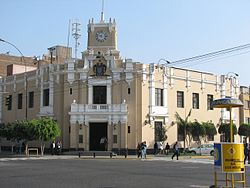
The main Catholic church is Nuestra Señora de las Victorias, located along with the district municipality's headquarters in the central Plaza Manco Cápac, whose monument was donated in 1926 by the Japanese colony in Peru on the occasion of the centenary of Peru's independence. It also has other churches such as those of San Ricardo, in Matute (which has a public swimming pool), San Antonio María Claret, Nuestra Señora del Buen Consejo, San Norberto (consecrated on July 15, 1963, in the Santa Catalina urbanization), in addition to the Our Lady of Guadalupe Parish Sanctuary in the Balconcillo urbanization.

Among the district's hospital infrastructure is the old Hospital Obrero, today known as the Guillermo Almenara Irigoyen National Hospital  [ es ], which belongs to the Social Security of Peru  [ es ] and is located on Avenida Grau. Additionally, La Victoria has a shelter for the underprivileged called Hogar de la Paz that is administered by the Missionaries of Charity.

A place of interest in the district is the Calvetti house located at the intersection of Hipólito Unanue and Iquitos Avenue. It features the longest balcony in Peru, with a length of 99.22 m (325.5 ft) and which was built in 1924. [8] [9]

Authorities

Municipal

Police

Religious

Festivities

Procession of Lord of Miracles of La Victoria District, Nov 2008 SMLV20080001.JPG
Procession of Lord of Miracles of La Victoria District, Nov 2008

Related Research Articles

<span class="mw-page-title-main">Lima</span> Capital and largest city of Peru

Lima, founded in 1535 as the Ciudad de los Reyes, is the capital and largest city of Peru. It is located in the valleys of the Chillón, Rímac and Lurín Rivers, in the desert zone of the central coastal part of the country, overlooking the Pacific Ocean. The city is considered the political, cultural, financial and commercial center of Peru. Due to its geostrategic importance, the Globalization and World Cities Research Network has categorized it as a "beta" tier city. Jurisdictionally, the metropolis extends mainly within the province of Lima and in a smaller portion, to the west, within the Constitutional Province of Callao, where the seaport and the Jorge Chávez Airport are located. Both provinces have regional autonomy since 2002.

<span class="mw-page-title-main">Walls of Lima</span> 17th-century fortification in Lima

The Walls of Lima were a fortification consisting mainly of walls and bastions whose purpose was to defend the city of Lima from exterior attacks. It was built between 1684 and 1687, during the Viceroy Melchor de Navarra y Rocafull 's government.

<span class="mw-page-title-main">San Martín de Porres District</span> District in Lima, Peru

San Martín de Porres (SMP) is a district in Lima, Peru, located in the north area of the city. It is bordered by the Chillón River, marks its natural border with Ventanilla and Puente Piedra on the north; Callao on the west; Los Olivos, Comas on the northeast; Rímac and Independencia districts on the east; the Rímac River marks its natural border with Lima District and Carmen de la Legua Reynoso on the south. It is the second most populated district of Lima metropolitan area and Peru.

<span class="mw-page-title-main">San Borja District</span> District in Lima, Peru

San Borja is a district of the Lima Province in Peru, and one of the upscale districts that comprise the city of Lima. Originally part of the district of Surquillo and San Isidro, it became officially established as a separate district on June 1, 1983. The new district took its name from a former hacienda (estate) which dominated the area. The district's postal code is 41. The current mayor (alcalde) is Marco Antonio Álvarez Vargas.

<span class="mw-page-title-main">Luis Galarreta</span> Peruvian Fujimorist politician

Luis Fernando Galarreta Velarde is a Peruvian Fujimorist politician and a former Congressman representing Lima between 2006 and 2020. He was President of the Congress for the 2017–2018 annual term. Galarreta was part of the presidential ticket of Keiko Fujimori in the 2021 elections that lost the elections to the Pedro Castillo ticket, however, he was elected to the Andean Parliament.

<span class="mw-page-title-main">Víctor Larco Herrera District</span> District in La Libertad, Peru

Víctor Larco Herrera also called commonly Víctor Larco is a district and a city of the north coast of Peru. It is located on a plain along the Pacific Ocean and is linked by a conurbation with Trujillo in La Libertad region. It is considered one of the 9 districts of the urban area known as Trujillo Metropolitano, one of the most populous metropolitan areas of Peru; it is also one of the 11 districts of Trujillo province. Victor Larco is the district that has the highest human development index (HDI) out of Lima Metropolitana, according to a study published by the United Nations Development Programme. In the early twentieth century, for its mild climate and fresh, it was known as Buenos Aires and then in 1945 got the name of Victor Larco Herrera in memory of the illustrious philanthropist Trujillan who was a benefactor of the city.

<span class="mw-page-title-main">Salaverry-Santa Cruz War</span> Civil war in Peru

The Salaverry-Santa Cruz War, sometimes called the Peruvian Civil War of 1835–1836, was an internal conflict in Peru with the involvement of the Bolivian army of Andres de Santa Cruz. It ended with the defeat and execution of Felipe Santiago Salaverry and the creation of the Peru-Bolivian Confederation.

<span class="mw-page-title-main">Paseo de los Héroes Navales</span> Park and culture heritage site in Lima

The Promenade of the Naval Heroes is a public park located in the historic centre of Lima. It occupies the first block of the Paseo de la República. It was given its current name on October 8, 1979 in commemoration of the centenary of the battle of Angamos.

<span class="mw-page-title-main">Plaza Grau</span> Plaza in Lima

The Plaza Grau is a public square located in the center of Lima, Peru. It is located at the intersection of the Paseo de la República with the Paseo Colón, Miguel Grau Avenue and the Paseo de los Héroes Navales. It was named in honor of Miguel Grau Seminario, commander of the Huáscar monitor during the War of the Pacific.

<span class="mw-page-title-main">Monument to Miguel Grau Seminario</span> Monument in Lima

The Monument to Miguel Grau Seminario is a commemorative monument located in Plaza Grau, in the historic centre of Lima, Peru. The monument was declared as movable property part of the Cultural Heritage of the Nation.

<span class="mw-page-title-main">Avenida España (Lima)</span> Avenue in Lima, Peru

Spain Avenue, formerly known as the Avenue of the Exhibition and then as Alfonso XIII Avenue until 1931, is an avenue in Lima, Peru. It extends from east to west in the districts of Lima and Breña along 7 blocks. The tracks of the Metropolitano extend along its route between Paseo de la República and Alfonso Ugarte Avenue.

<span class="mw-page-title-main">Vía Expresa Luis Fernán Bedoya Reyes</span> Avenue in Lima, Peru

Luis Fernán Bedoya Reyes Expressway, also known by its former name, Paseo de la República, or by its nickname, El Zanjón, is the most representative avenue of Lima, Peru. It crosses the districts of Lima, Lince, La Victoria, San Isidro, Surquillo, Miraflores, Barranco and Chorrillos from north to south along 66 blocks. COSAC I of the Metropolitano extends along its entire length, being one of the widest avenues in the city and country.

<span class="mw-page-title-main">Monument to Manco Cápac</span> Monument in La Victoria, Peru

The Monument to Manco Cápac is a statue located in the homonymous square in La Victoria District, Lima, the work of the Peruvian sculptor David Lozano, inaugurated in 1926.

<span class="mw-page-title-main">Miguel Grau Avenue (Lima)</span> Avenue in Lima, Peru

Miguel Grau Avenue, formerly known as Alameda Grau, is a major avenue that forms part of the historic centre of Lima, Peru. It starts at the public square of the same name continuing the path laid out by the Paseo Colón, and continues until it reaches El Ángel Cemetery, passing through the districts of Lima, La Victoria and El Agustino. It partially overlaps the layout of the old walls of Lima.

<span class="mw-page-title-main">Jirón Gamarra</span> Street in Lima, Peru

Jirón Agustín Gamarra is one of the main streets of the district of La Victoria, also forming part of the neighbourhood of Barrios Altos, itself part of the historic centre of Lima, Peru. Over forty blocks long, it is best known for the Gamarra Commercial Emporium, which houses fashion stores and textile manufacturing workshops.

<span class="mw-page-title-main">Royal College of the University of San Marcos</span> Historical building in Lima, Peru

The Royal College of the University of San Marcos, also known by its former name of Royal College of San Felipe, is a historic building in the Barrios Altos neighbourhood of Lima, Peru. It's one of two cultural centres operated by the University of San Marcos.

<span class="mw-page-title-main">Santa Catalina, Lima</span> Neighbourhood in Peru

Santa Catalina is a neighbourhood in La Victoria District, Lima, Peru. Originally an Ichma settlement, it is currently an area inhabited by upper middle class families, making it the best consolidated area of the district, where it is the epicenter of construction for many real estate companies. Likewise, it is where the tallest residential buildings in Lima are located. It is considered the safest and best looking area in the district.

<span class="mw-page-title-main">Church of Our Lady of the Forsaken, Lima</span> Church in Lima, Peru

The Church of Our Lady of the Forsaken and of Saint Joseph, known commonly as the Church of the Forsaken, is a Catholic church located between Venezuela Avenue and the Jirón Recuay of the main square of Breña, in Lima, Peru.

<i>Polvos Azules</i> Shopping centre in Lima, Peru

Polvos Azules is a shopping centre located in La Victoria District, Lima, Peru. Originally located behind Government Palace, it has since moved to its current location next to the Paseo de la República expressway, keeping the name it inherited from its original location, today the Alameda Chabuca Granda.

References

  1. "Estadística Poblacional - Ministerio de Salud del Perú".
  2. "Vicarías Episcopales". Arzobispado de Lima (in Spanish). Retrieved 2022-10-06.
  3. PERÚ, NOTICIAS EL COMERCIO (2019-03-14). "Gamarra: ¿cómo surgió el emporio comercial que hoy busca librarse de los ambulantes? | SOMOS". El Comercio Perú (in Spanish). Retrieved 2020-12-10.
  4. "Una breve historia del distrito de La Victoria | Blog de Marco Gamarra Galindo" (in European Spanish). Retrieved 2020-12-10.
  5. "Zonificación" (PDF). Municipalidad de La Victoria (in Spanish). October 2016. Archived from the original (PDF) on 2021-10-17. Retrieved 2021-02-28.
  6. Planos estratificados de Lima Metropolitana a nivel de manzanas 2020 (PDF) (in Spanish). Lima: Instituto Nacional de Estadística e Informática. 2020. p. 31. Archived from the original (PDF) on 2022-07-15. Retrieved 2022-02-17.
  7. Vega Córdova, Élida (2020-12-28). "¿Cuál es el atractivo principal de Santa Catalina para ser sede de un "boom" inmobiliario? | Santa Catalina | sector inmobiliario | venta de departamentos | | ECONOMIA". Peru21 (in Spanish). Retrieved 2021-02-28.
  8. "El balcón más largo del Perú". Municipalidad de la Victoria (in Spanish). Archived from the original on 2021-01-17. Retrieved 2021-02-28.
  9. Gamarra Galindo, Marco (2011-10-15). "El balcón más largo del Perú está en La Victoria". Pontifical Catholic University of Peru (in Spanish). Archived from the original on 2021-10-26. Retrieved 2021-02-28.
  10. "George Forsyth renunció a la alcaldía de La Victoria: Envió carta al JNE". canaln.pe (in Spanish). Retrieved 2022-10-07.
  11. "Alianza Lima felicitó a George Forsyth por ser electo nuevo alcalde de La Victoria". Perú21. Lima. 11 October 2018. Retrieved 28 February 2021.
  12. JNE Autoridades regionales y municipales 2015-2018 Archived 2015-12-15 at the Wayback Machine
  13. "La Victoria: Concejo acordó vacancia del suspendido alcalde Elías Cuba".
  14. "JNE Autoridades regionales y municipales 2011-2014". Archived from the original on 7 April 2014. Retrieved 20 March 2012.
  15. "Comité Distrital de Seguridad Ciudadana". Archived from the original on 13 August 2014. Retrieved 12 August 2014.