San Miguel District, Lima

Last updated
Saint Michael District
Distrito de San Miguel (Spanish)
Plaza San Miguel de noche en Lima.jpg
Plaza San Miguel, a mall in San Miguel
Bandera de San Miguel (Lima).png
Escudo de San Miguel.png
Map of Lima highlighting San Miguel.PNG
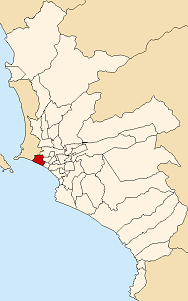
Location of San Miguel in the Lima province
Coordinates: 12°4′38″S77°5′34″W / 12.07722°S 77.09278°W / -12.07722; -77.09278
Country Peru
Region Lima
Province Lima
FoundedOctober 5, 1920
Government
   Mayor Eduardo Bless
(2023-2026)
Area
  Total10.72 km2 (4.14 sq mi)
Population
 (2023) [1]
  Total183,597
   Demonym
San miguelino/a
Time zone UTC-5 (PET)
UBIGEO 150136
Website www.munisanmiguel.gob.pe

San Miguel is one of the 43 districts that are part of the Lima province and of the urban area of Lima, Peru. It is bordered by the districts of Bellavista and downtown Lima on the north; Pueblo Libre, Magdalena del Mar and downtown Lima on the east; the Pacific Ocean on the south; and the La Perla district on the west.

Contents

San Miguel is an upper-class (65% of its population) and upper-middle class (35%) district with a very high HDI. [2]

See also

Related Research Articles

<span class="mw-page-title-main">Lima</span> Capital and largest city of Peru

Lima is the capital and largest city of Peru. It is located in the valleys of the Chillón, Rímac and Lurín Rivers, in the desert zone of the central coastal part of the country, overlooking the Pacific Ocean. The city is considered the political, cultural, financial and commercial center of Peru. Due to its geostrategic importance, the Globalization and World Cities Research Network has categorized it as a "beta" tier city. Jurisdictionally, the metropolis extends mainly within the province of Lima and in a smaller portion, to the west, within the Constitutional Province of Callao, where the seaport and the Jorge Chávez Airport are located. Both provinces have regional autonomy since 2002.

<span class="mw-page-title-main">Santiago de Surco</span> District in Lima, Peru

Santiago de Surco, commonly known simply as Surco, is a district of Lima, Peru. It is bordered on the north with the district of Ate Vitarte and La Molina; on the east with San Juan de Miraflores, on the west with San Borja, Surquillo, Miraflores and Barranco, and on the south with Chorrillos.

<span class="mw-page-title-main">San Isidro District, Lima</span> District in Lima, Peru

San Isidro is an upscale district of the Lima Province in Peru. It is located in the west center of the city, it has a few meters of coastline. Officially created on April 24, 1931, San Isidro, along with Orrantia and Country Club districts, was separated from Miraflores.

<span class="mw-page-title-main">Lima District</span> District in Lima, Peru

Lima is a district of Lima Province in Peru. Lima district is the oldest in Lima Province and as such, vestiges of the city's colonial era remain today in the historic centre of Lima, which was declared a UNESCO World Heritage Site in 1988 and contains the foundational area known as Cercado de Lima.

<span class="mw-page-title-main">Lima metropolitan area</span> Place in Peru

The Lima Metropolitan Area is an area formed by the conurbation of the Peruvian provinces of Lima and Callao. It is the largest of the metropolitan areas of Peru, the seventh largest in the Americas, the fourth largest in Latin America, and among the thirty largest in the world. The conurbation process started to be evident in the 1980s.

<span class="mw-page-title-main">Rímac District</span> District in Lima, Peru

Rímac, known until the 19th century as the neighbourhood of San Lázaro, is a district in the Lima Province, Peru. It lies directly to the north of downtown Lima, to which it is connected by six bridges over the Rímac River. The district also borders the Independencia, San Martín de Porres, and San Juan de Lurigancho districts. Vestiges of Lima's colonial heyday remain today in an area of the Rímac district known as the Historic centre of Lima, which was declared a UNESCO World Heritage Site in 1988. Downtown Rímac District has, like its southern counterpart, its eastern and western sides divided by Jirón Trujillo, which connects to Lima District's Jirón de la Unión through the Puente de Piedra, the oldest bridge in the whole city. Rímac's East side features the Plaza de Acho, the most famous bullfighting arena in South America and one of the most well known in the world.

<span class="mw-page-title-main">Bellavista District</span> District in Callao, Peru

Bellavista is a district of the Constitutional Province of Callao in Peru, and one of the seven districts that comprise the port city of Callao.

<span class="mw-page-title-main">San Juan de Lurigancho</span> District in Lima, Peru

San Juan de Lurigancho (SJL) is a district in Lima, Peru, located in the area known as Cono Este. It is Peru's most populous district, with a current population that may exceed one million.

<span class="mw-page-title-main">La Victoria District, Lima</span> District in Lima, Peru

The district of La Victoria is one of the forty-three districts that make up the province of Lima, located in Peru. It borders to the north and northeast with the district of Lima, to the east with the district of San Luis, to the southeast with the district of San Borja, to the south with the district of San Isidro, and to the west with the district of Lince and again with the Lima district. La Victoria is a historical and very busy public district located in downtown Lima. The current mayor of La Victoria is Rubén Dioscorides Andrés Cano Altez.

<span class="mw-page-title-main">Jesús María District, Lima</span> District in Lima, Peru

Jesús María is one of the most centrally located districts of Lima, Peru. It is an upper class, high-density district and it usually ranks in the top districts with the best quality of life in Peru with an HDI of 0.8372 (2019), only behind the districts of La Molina and Lince.

<span class="mw-page-title-main">Magdalena del Mar District</span> District in Lima, Peru

Magdalena del Mar, commonly known simply as Magdalena, is a seaside district of the Lima Province in Peru and one of the districts that comprise the city of Lima. Its current mayor is Francis Allison Oyague. Magdalena was officially established as a district on May 10, 1920.

<span class="mw-page-title-main">Comas District, Lima</span> District in Lima, Peru

The district of Comas is one of the forty-three districts that make up the province of Lima, located in the department of the same name, in Perú. It is located in the north area of the city. It is one of the most populous districts in Lima.

<span class="mw-page-title-main">Miraflores District, Lima</span> District in Peru

Miraflores is a district of the Lima Province in Peru. It is a residential and upscale shopping district south of downtown Lima. It is also one of the wealthiest districts that make up the city of Lima. It has several hotels, restaurants, bars, nightclubs, and department stores. Miraflores is one of the main tourist destinations in Lima.

<span class="mw-page-title-main">Ate District</span> District in Lima, Peru

The Ate district, also called Ate-Vitarte, is one of the forty-three districts that make up the Lima Province, located in Peru.

<span class="mw-page-title-main">Lurigancho-Chosica</span> District in Lima, Peru

Lurigancho-Chosica is a district of Lima Province, Peru, located in the valley of the Rímac River, which it shares with neighboring Chaclacayo and Ate districts. Its capital is the town of Chosica. Its administrative center is located 861 m (2,825 ft) above sea level.

<span class="mw-page-title-main">Los Olivos District</span> District in Lima, Peru

Los Olivos is a district of the Lima Province in Peru. Is a District of the Cono Norte area in the city of Lima.

<span class="mw-page-title-main">Pueblo Libre District, Lima</span> District in Lima, Peru

Pueblo Libre is a district of the Lima Province in Peru. Its name, which means Free Town or Free People, was granted by José de San Martín on April 10, 1822, as a recognition of the patriotism shown by its inhabitants during the Peruvian War of Independence. The district was created by law 9162 on November 5, 1940. Pueblo Libre is a middle-class residential community and has the most parks in Lima, although it has several branches of banks, local private universities and major corporations. The current mayor of Pueblo Libre is Mónica Rossana Tello López

<span class="mw-page-title-main">San Juan de Miraflores</span> District in Peru

The district of San Juan de Miraflores is one of the forty-three districts that make up the province of Lima, located in the department of the same name, in Peru. Is one of the new towns, that have been formed by the massive numbers of people moving from other towns of Metropolitan Lima and from the countryside. During the early 1960s, was mostly a desert area.

<span class="mw-page-title-main">Carabayllo District</span> District in Lima, Peru

Carabayllo is one of the 43 districts of the province Lima in Peru. It is located in the Cono Norte area of the province and was created district by General José de San Martín in August 4, 1821 at which time it was the only district to occupy the area north of the Rímac River up to the province Canta.

<span class="mw-page-title-main">Peruvian University of Applied Sciences</span>

The Universidad Peruana de Ciencias Aplicadas (UPC) is a private university in Lima, Peru, founded on January 5, 1994. Currently, it offers 46 career programs categorized in 13 schools.

References

  1. "Estadística Poblacional - Ministerio de Salud del Perú".
  2. Instituto Nacional de Estadística e Informática (2020). Planos estratificados de Lima Metropolitana a nivel de manzanas 2020 (PDF). Lima. p. 52.{{cite book}}: CS1 maint: location missing publisher (link)