Magdalena del Mar District

Last updated
Magdalena of the Sea District
Distrito de Magdalena del Mar (Spanish)
Cuarentena Lima (18 de marzo).jpg
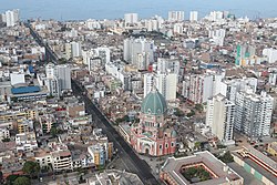
Aerial view in 2020, the Church can be seen
Bandera Magdalena del Mar.png
Escudo de Magdalena del Mar.png
Lica-magdalenadelmar.png
Location of Magdalena del Mar in the Lima Province
Coordinates: 12°06′S77°05′W / 12.100°S 77.083°W / -12.100; -77.083
Country Flag of Peru.svg  Peru
Region Lima
Province Lima
FoundedMay 10, 1920
Capital Magdalena del Mar
Subdivisions 1 populated center
Government
   Mayor Francis Allison (APP)
(2023-2026)
Area
  Total3.61 km2 (1.39 sq mi)
Elevation
58 m (190 ft)
Population
 (2023) [1]
  Total69,488
Time zone UTC-5 (PET)
UBIGEO 150120
Website munimagdalena.gob.pe

Magdalena del Mar, commonly known simply as Magdalena, is a seaside district of the Lima Province in Peru and one of the districts that comprise the city of Lima. Its current mayor is Francis Allison Oyague. Magdalena was officially established as a district on May 10, 1920.

Contents

Geography

With a total land area of 3.61 km², Magdalena borders the districts of San Miguel on the west, Pueblo Libre and Jesús María on the north, San Isidro on the east, and the Pacific Ocean on the south.

For more than fifty years, the eastern border of the district has been disputed with neighboring San Isidro. A judge ordered the councils of both districts to deposit the money of the affected areas' taxpayers in the National Bank of Peru until this long-standing conflict is resolved.[ citation needed ]

Transportation

The main avenues that connect the district with the rest of the city are the Ejercito avenue, the Brasil avenue, the Javier Prado avenue, the Juan de Aliaga Avenue and the Sucre avenue.

There are many bus routes operated by private companies that go through the district, however, the main publicly owned bus lines are the 201, 202, 204 and 209 line from the Corredor Rojo.

Demographics

According to a 2002 estimate by the INEI, the district has 52,976 inhabitants and a population density of 14,674.8 persons/km².

See also

Related Research Articles

<span class="mw-page-title-main">Lima</span> Capital and largest city of Peru

Lima is the capital and largest city of Peru. It is located in the valleys of the Chillón, Rímac and Lurín Rivers, in the desert zone of the central coastal part of the country, overlooking the Pacific Ocean. The city is considered the political, cultural, financial and commercial center of Peru. Due to its geostrategic importance, the Globalization and World Cities Research Network has categorized it as a "beta" tier city. Jurisdictionally, the metropolis extends mainly within the province of Lima and in a smaller portion, to the west, within the Constitutional Province of Callao, where the seaport and the Jorge Chávez Airport are located. Both provinces have regional autonomy since 2002.

<span class="mw-page-title-main">Huacho</span> City in Lima, Peru

Huacho is a city in Peru, capital of the Huaura Province and capital of the Lima Region. Also is the most populated city of the Lima Region and Norte Chico. It is located 223 feet above sea level and 148 km north of the city of Lima. The city is located on the Pan-American Highway and it is close to the Lachay National Reserve, so it has extensive vegetation and wildlife.

<span class="mw-page-title-main">Santiago de Surco</span> District in Lima, Peru

Santiago de Surco, commonly known simply as Surco, is a district of Lima, Peru. It is bordered on the north with the district of Ate Vitarte and La Molina; on the east with San Juan de Miraflores, on the west with San Borja, Surquillo, Miraflores and Barranco, and on the south with Chorrillos.

<span class="mw-page-title-main">San Isidro District, Lima</span> District in Lima, Peru

San Isidro is an upscale district of the Lima Province in Peru. It is located in the west center of the city, it has a few meters of coastline. Officially created on April 24, 1931, San Isidro, along with Orrantia and Country Club districts, was separated from Miraflores.

<span class="mw-page-title-main">Lima District</span> District in Lima, Peru

Lima is a district of Lima Province in Peru. Lima district is the oldest in Lima Province and as such, vestiges of the city's colonial era remain today in the historic centre of Lima, which was declared a UNESCO World Heritage Site in 1988 and contains the foundational area known as Cercado de Lima.

<span class="mw-page-title-main">Lima metropolitan area</span> Place in Peru

The Lima Metropolitan Area is an area formed by the conurbation of the Peruvian provinces of Lima and Callao. It is the largest of the metropolitan areas of Peru, the seventh largest in the Americas, the fourth largest in Latin America, and among the thirty largest in the world. The conurbation process started to be evident in the 1980s.

<span class="mw-page-title-main">La Molina District</span> District in Lima, Peru

The district of La Molina is one of the forty-three districts that make up the province of Lima, located in the department of the same name, in Peru. Officially established as a district on February 6, 1962. The current mayor of La Molina is Esteban Diego Uceda Guerra-García.

<span class="mw-page-title-main">San Miguel District, Lima</span> District in Lima, Peru

San Miguel is one of the 43 districts that are part of the Lima province and of the urban area of Lima, Peru. It is bordered by the districts of Bellavista and downtown Lima on the north; Pueblo Libre, Magdalena del Mar and downtown Lima on the east; the Pacific Ocean on the south; and the La Perla district on the west.

<span class="mw-page-title-main">San Juan de Lurigancho</span> District in Lima, Peru

San Juan de Lurigancho (SJL) is a district in Lima, Peru, located in the area known as Cono Este. It is Peru's most populous district, with a current population that may exceed one million.

<span class="mw-page-title-main">La Victoria District, Lima</span> District in Lima, Peru

The district of La Victoria is one of the forty-three districts that make up the province of Lima, located in Peru. It borders to the north and northeast with the district of Lima, to the east with the district of San Luis, to the southeast with the district of San Borja, to the south with the district of San Isidro, and to the west with the district of Lince and again with the Lima district. La Victoria is a historical and very busy public district located in downtown Lima. The current mayor of La Victoria is Rubén Dioscorides Andrés Cano Altez.

<span class="mw-page-title-main">San Borja District</span> District in Lima, Peru

San Borja is a district of the Lima Province in Peru, and one of the upscale districts that comprise the city of Lima. Originally part of the district of Surquillo and San Isidro, it became officially established as a separate district on June 1, 1983. The new district took its name from a former hacienda (estate) which dominated the area. The district's postal code is 41. The current mayor (alcalde) is Marco Antonio Álvarez Vargas.

<span class="mw-page-title-main">Jesús María District, Lima</span> District in Lima, Peru

Jesús María is one of the most centrally located districts of Lima, Peru. It is an upper class, high-density district and it usually ranks in the top districts with the best quality of life in Peru with an HDI of 0.8372 (2019), only behind the districts of La Molina and Lince.

<span class="mw-page-title-main">Miraflores District, Lima</span> District in Peru

Miraflores is a district of the Lima Province in Peru. It is a residential and upscale shopping district south of downtown Lima. It is also one of the wealthiest districts that make up the city of Lima. It has several hotels, restaurants, bars, nightclubs, and department stores. Miraflores is one of the main tourist destinations in Lima.

<span class="mw-page-title-main">Pueblo Libre District, Lima</span> District in Lima, Peru

Pueblo Libre is a district of the Lima Province in Peru. Its name, which means Free Town or Free People, was granted by José de San Martín on April 10, 1822, as a recognition of the patriotism shown by its inhabitants during the Peruvian War of Independence. The district was created by law 9162 on November 5, 1940. Pueblo Libre is a middle-class residential community and has the most parks in Lima, although it has several branches of banks, local private universities and major corporations. The current mayor of Pueblo Libre is Mónica Rossana Tello López

<span class="mw-page-title-main">Lince District</span> District in Lima, Peru

Lince is a district of the Lima Province in Peru. It is part of the city of Lima. Officially established as a district on May 29, 1936, the current mayor (alcalde) of Lince is Vicente Amable Escalante. The district's postal code is 14. Until 1936, when it was made into a separate district, Lince was attached to Miraflores and San Isidro district.

A Peruvian postal code is a five-digit string that comprises part of a postal address in Peru. Prior to 2011, only the major cities of Lima and Callao used postal codes. However, in February 2011 a nationwide system was implemented which employs a five-digit numeric format. Similar to the postal codes of Mexico, Brazil, Australia, the United States, and elsewhere, postal codes in Peru are strictly numerical, using only numbers.

<span class="mw-page-title-main">Avenida Javier Prado</span> Major avenue in Lima, Peru

The Javier Prado Avenue is one of the main avenues of Lima, capital of Peru. By its length it is the second largest avenue of the city, after the Universitaria Avenue. It goes from west to east, going through the districts of Magdalena del Mar, San Isidro, Lince, La Victoria, San Borja, Santiago de Surco, Ate and La Molina along 135 blocks.

<span class="mw-page-title-main">Salaverry Avenue</span> Avenue in Lima, Peru

General Felipe Salaverry Avenue is a major avenue in Lima, Peru.

The Mosque of Lima, also known as the Mosque of Magdalena del Mar, is a mosque in Lima, Peru. It is one of two mosques in the country, the other being Bab al-Islam Mosque.

References

  1. "Estadística Poblacional - Ministerio de Salud del Perú".