This article describes the transport in Peru.

Lima, founded in 1535 as the Ciudad de los Reyes, is the capital and largest city of Peru. It is located in the valleys of the Chillón, Rímac and Lurín Rivers, in the desert zone of the central coastal part of the country, overlooking the Pacific Ocean. The city is considered the political, cultural, financial and commercial center of Peru. Due to its geostrategic importance, the Globalization and World Cities Research Network has categorized it as a "beta" tier city. Jurisdictionally, the metropolis extends mainly within the province of Lima and in a smaller portion, to the west, within the Constitutional Province of Callao, where the seaport and the Jorge Chávez Airport are located. Both provinces have regional autonomy since 2002.

Pueblos jóvenes is the term used for the shanty towns that surround Lima and other cities of Peru. Many of these towns have developed into districts of Lima such as Comas, Los Olivos and Villa El Salvador.

Lima is a district of Lima Province in Peru. Lima district is the oldest in Lima Province and as such, vestiges of the city's colonial era remain today in the historic centre of Lima, which was declared a UNESCO World Heritage Site in 1988 and contains the foundational area known as Cercado de Lima.
The Rímac River is located in western Peru and is the most important source of potable water for the Lima and Callao Metropolitan Area. It belongs to the Pacific Slope, into which it flows after bathing the cities of Lima and Callao, together with the Chillón River, to the north, and the Lurín River, to the south. It is 204 km long and has a basin of 3,312 km², of which 2,237.2 km² is a humid basin. The basin has a total of 191 lagoons, of which only 89 have been studied. The river begins in the highlands of the Huarochirí Province in the Lima Region and its mouth is located in Callao, near Jorge Chávez International Airport.
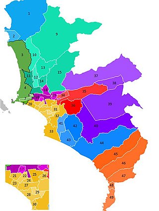
The Lima Metropolitan Area is an area formed by the conurbation of the Peruvian provinces of Lima and Callao. It is the largest of the metropolitan areas of Peru, the seventh largest in the Americas, the fourth largest in Latin America, and among the thirty largest in the world. The conurbation process started to be evident in the 1980s.

Rímac, known until the 19th century as the neighbourhood of San Lázaro, is a district in the Lima Province, Peru. It lies directly to the north of downtown Lima, to which it is connected by six bridges over the Rímac River. The district also borders the Independencia, San Martín de Porres, and San Juan de Lurigancho districts. Vestiges of Lima's colonial heyday remain today in an area of the Rímac district known as the Historic centre of Lima, which was declared a UNESCO World Heritage Site in 1988. Downtown Rímac District has, like its southern counterpart, its eastern and western sides divided by Jirón Trujillo, which connects to Lima District's Jirón de la Unión through the Puente de Piedra, the oldest bridge in the whole city. Rímac's East side features the Plaza de Acho, the most famous bullfighting arena in South America and one of the most well known in the world.

San Martín de Porres (SMP) is a district in Lima, Peru, located in the north area of the city. It is bordered by the Chillón River, marks its natural border with Ventanilla and Puente Piedra on the north; Callao on the west; Los Olivos, Comas on the northeast; Rímac and Independencia districts on the east; the Rímac River marks its natural border with Lima District and Carmen de la Legua Reynoso on the south. It is the second most populated district of Lima metropolitan area and Peru.

San Juan de Lurigancho (SJL) is a district in Lima, Peru, located in the area known as Cono Este. It is Peru's most populous district, with a current population that may exceed one million.
The Ate district, also called Ate-Vitarte, is one of the forty-three districts that make up the Lima Province, located in Peru.

Lurigancho-Chosica is a district of Lima Province, Peru, located in the valley of the Rímac River, which it shares with neighboring Chaclacayo and Ate districts. Its capital is the town of Chosica. Its administrative center is located 861 m (2,825 ft) above sea level.
A Peruvian postal code is a five-digit string that comprises part of a postal address in Peru. Prior to 2011, only the major cities of Lima and Callao used postal codes. However, in February 2011 a nationwide system was implemented which employs a five-digit numeric format. Similar to the postal codes of Mexico, Brazil, Australia, the United States, and elsewhere, postal codes in Peru are strictly numerical, using only numbers.

Carabayllo is one of the 43 districts of the province Lima in Peru. It is located in the Cono Norte area of the province and was created district by General José de San Martín in August 4, 1821 at which time it was the only district to occupy the area north of the Rímac River up to the province Canta.

Cieneguilla is one of the 43 districts that make up the Lima Province. It is located in the easternmost area of the province and is one of the few districts left that is not already completely urbanized.
San Antonio de Chaclla is one of the thirty-two districts of the province of Huarochirí, in the Department of Lima, in Peru. It borders to the north with the districts of Santa Rosa de Quives and Arahuay, both belonging to the province of Canta; to the east with the districts of Huachupampa, San Pedro de Casta, and Santa Eulalia; to the south with the district of Lurigancho-Chosica, province of Lima; and to the west with the districts of San Juan de Lurigancho and Carabayllo, both belonging to the province of Lima.
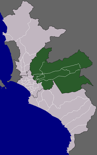
The Cono Este or Lima Este is one of the six areas that make up the Lima Metropolitan Area. It is located in the eastern part of the metropolis hence its name. The socioeconomic levels of its residents are varied. They mainly belong however to the middle class. Wealthier residents can be found in a few districts in this area as many people move to this area to escape the cloudy winters of Lima. During the winter, this is the only area of Lima that is not permanently covered by fog. The most developed areas of this section are certain retirement urbanizations in Lurigancho-Chosica and Chaclacayo. These areas are home to picturesque winter housing developments owned by people seeking to escape the winter fog. Santa Anita presents the highest degree of urban consolidation, while being the smallest district on the area. La Molina is a mainly residential district which gathers people of the high socioeconomic status, it also concentrates commercial activities. The least developed are those of El Agustino which is populated by slum housing, and Cieneguilla, which is mostly unurbanized. The district of Ate has to some extent undergone industrialization with several factories having been built there.

The urban community of Huaycán is a town of Lima, Peru, located in Ate District, approximately 16.5 kilometres east of Lima. It is home to thousands of immigrant settlers from different parts of Peru, looking to improve their standard of living and job opportunities in the city of Lima.

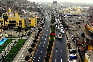
The Carretera Central of Peru or National Route 22 is a two-lane highway that crosses through Central Peru. It begins in the city of Lima, and connects with the department of Junin in Central Peru. An update to the highway with an expansion to four lanes was announced in 2020 and is expected to be completed by 2025.
Comunidad Cristiana Agua Viva is a charismatic evangelical megachurch in Lima, Peru. As of 2017, it has seven locations in Lima Province.
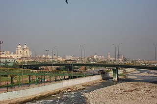
Ricardo Palma Bridge is a reinforced concrete beam bridge that crosses the Rímac river, connecting Abancay Avenue with Jirón Hualgayoc and thus connecting the districts of Lima and Rímac, both part of the historic centre of Lima, the capital city of Peru. It is named after the Peruvian author, scholar, librarian and politician Ricardo Palma.