Created by Law 9162 of November 5, 1940,[3] it is a middle-class residential district and has the most parks in Lima, also housing several branches of banks, local private universities and major corporations. Its name was granted by José de San Martín on April 10, 1822, as a recognition of the patriotism shown by its inhabitants during the Peruvian War of Independence.
History
Pueblo Libre was founded in 1557 as Magdalena Vieja, before being renamed the Pueblo de los Libres in 1821 by José de San Martín.[2] The name was given because of the great patriotism and desire for freedom San Martin saw from the people. Simón Bolívar, one of the liberators of South America, lived in Pueblo Libre. His colonial mansion is known today as the Palacio de la Magdalena, which houses the National Museum of Archaeology, Anthropology and History of Peru, having formerly housed the Magdalena government of Peru during the War of the Pacific. The Museum, also known by its initials MNAAHP, has collections of artifacts from Peruvian culture. It is one of the most visited museums in Lima and it is located at the heart of the district. Pueblo Libre has a rich history - museums, famous restaurants, and art galleries which are located in this district of Lima.
One of Pueblo Libre's oldest attractions is La Cruz del Viajero (The Cross of the Traveler). The cross was a symbol of faith and protection the conquistadores brought from Spain. Francisco Pizarro placed the cross in Pueblo Libre; soldiers would pray before going to war or when making a hard distant journey.
Situated not a long walk from Pueblo Libre's pleasant plaza is the Museo Larco Hererra, which houses the largest collection of Moche artifacts in the country. This museum is known for having one of the best pre-Columbian exhibits in the world.[citation needed] It offers Paracas textiles and a huge collection of pottery. In the history section of the museum, it documents of the brutality of the Spaniards in the country and of the challenges it has faced since its independence.
On December 15, 2019, two teenage employees died when they were doing cleaning chores in a McDonald's restaurant in the district, across the street from Plaza San Miguel, a popular shopping centre. The event caused nationwide outrage, and the restaurant was ultimately closed permanently.[4][5][6]
Other Attractions
In addition to the National Museum of Archaeology, Anthropology, and History of Peru, the Larco Museum, and the Cross of the Traveler, Pueblo Libre features several other notable cultural and historical landmarks:
Mateo Salado Archaeological Complex
The Mateo Salado Archaeological Complex, also known as the Huacas of Mateo Salado, is a pre-Columbian ceremonial center attributed to the Ychsma culture (c. 1100–1450 CE). Located near the district’s northern boundary, the site comprises five adobe pyramids and is considered one of Lima’s most significant archaeological remains. Restoration and conservation efforts have been ongoing since the early 2000s. [citation needed]
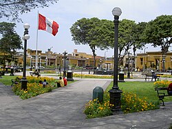
Plaza de la Bandera
The Plaza de la Bandera, also called as Flag Square is a monumental square dedicated to the Peruvian flag. It is frequently used for patriotic ceremonies and public commemorations, reflecting the district’s strong ties to Peru’s independence history.
Santiago Queirolo Tavern
The Santiago Queirolo Tavern, also known as the Antigua Taberna Queirolo, is one of Lima’s most traditional taverns. Established in the late 19th century, it is renowned for its pisco, wines, and classic Peruvian cuisine. The tavern remains a popular gathering place for locals and visitors, preserving the ambiance of Lima’s historic cantinas.
Geography
The district has a total land area of 4.38km2. Its administrative center is located 90 meters above sea level.
This page is based on this Wikipedia article Text is available under the CC BY-SA 4.0 license; additional terms may apply. Images, videos and audio are available under their respective licenses.