
Lima is the capital and the largest city of Peru. It is located in the valleys of the Chillón, Rímac and Lurín Rivers, in the desert zone of the central coastal part of the country, overlooking the Pacific Ocean. Together with the seaport of Callao, it forms a contiguous urban area known as the Lima Metropolitan Area. With a population of more than 9.5 million, Lima is one of the largest cities in the Americas.
Santiago de Surco, commonly known simply as Surco, is a district of Lima, Peru. It is bordered on the north with the district of Ate Vitarte and La Molina; on the east with San Juan de Miraflores, on the west with San Borja, Surquillo, Miraflores and Barranco, and on the south with Chorrillos.

Lima is a district of Lima Province in Peru. Lima district is the oldest in Lima Province and as such, vestiges of the city's colonial era remain today in the Historic centre of Lima, which was declared a UNESCO World Heritage Site in 1988 and contains the foundational area known as Cercado de Lima.

The Lima Metropolitan Area is an area formed by the conurbation of the Peruvian provinces of Lima and Callao. It is the largest of the metropolitan areas of Peru, the seventh largest in the Americas, the fourth largest in Latin America, and among the thirty largest in the world. The conurbation process started to be evident in the 1980s.

Rímac is a district in the Lima Province, Peru. It lies directly to the north of downtown Lima, to which it is connected by six bridges over the Rímac River. The district also borders the Independencia, San Martín de Porres, and San Juan de Lurigancho districts. Vestiges of Lima's colonial heyday remain today in an area of the Rímac district known as the Historic centre of Lima, which was declared a UNESCO World Heritage Site in 1988. Downtown Rímac District has, like its southern counterpart, its eastern and western sides divided by Jirón Trujillo, which connects to Lima District's Jirón de la Unión through the Puente de Piedra, the oldest bridge in the whole city. Rímac's East side features the Plaza de Acho, the most famous bullfighting arena in South America and one of the most well known in the world.

La Molina is a district of the Lima Province in Peru, and one of the upscale districts that comprise the province of Lima. Officially established as a district on February 6, 1962, the current mayor of La Molina is Álvaro Paz de la Barra.

San Juan de Lurigancho (SJL) is a district in Lima, Peru, located in the area known as Cono Este. It is Peru's most populous district, with a current population that may have exceeded one million.

La Victoria is a district the province of the Lima Province in Peru. It limits the North with the district of Lima; to the East with the districts of El Agustino, San Luis and San Borja; to the South with the district of San Isidro; and to the west with the Lince and Lima districts. From the hierarchical point of view of the Catholic Church, it is part of the Episcopal Vicariate V of the Archdiocese of Lima.1

Chaclacayo is a district of the Lima Province in Peru.

Ate, also known as Ate-Vitarte, is a district of the Lima Province in Peru. Located in the eastern part of the province, it is one of the districts that comprise the city of Lima.

Lurigancho-Chosica is a district of Lima Province, Peru, located in the valley of the Rímac River which it shares with neighboring Chaclacayo and Ate districts. It was created on January 2, 1857. Its capital is the town of Chosica. The district has a total land area of 236.47 km2 (91.30 sq mi). Its administrative center is located 861 m (2,825 ft) above sea level.

El Agustino is a district of the Lima Province in Peru. It is part of city of Lima. Officially established as a district on January 6, 1965, the current mayor (alcalde) of El Agustino is Víctor Modesto Salcedo Ríos. The district's postal code is 10.

Santa Anita is a district of the Lima Province in Peru. It is part of city of Lima. Officially established as a district on October 25, 1989 from parts of Ate and El Agustino separated by the Rio Surco, a ditch which went all the way to Santiago de Surco.
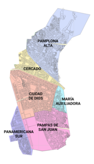
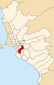
San Juan de Miraflores is a district of the Lima Province in Peru. It is located in the Cono Sur area of the city of Lima.

Carabayllo is one of the 43 districts of the province Lima in Peru. It is located in the Cono Norte area of the province and was founded by General José de San Martín in August 1821 at which time it was the only district to occupy the area north of the Rímac River up to the province Canta.

The Cono Norte is one of the five areas that make up the Lima Metropolitan Area. It is located in the northern part of the metropolis, hence its name. The socioeconomic levels of its residents are varied. The districts of Ancón and Santa Rosa are the popular beach resorts for wealthier residents of Lima. The rest of the population comprises middle class and lower class residents. It is one of the most populated areas of Peru.

Cieneguilla is one of the 43 districts that make up the Lima Province. It is located in the easternmost area of the province and is one of the few districts left that is not already completely urbanized.
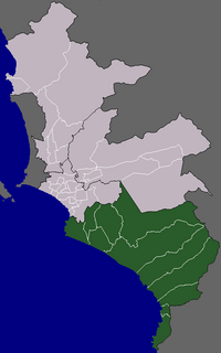
The Cono Sur is one of the five areas that make up the Lima Metropolitan Area. It is located in the southern part of the metropolis hence its name. This socioeconomic levels of this district are varied. Most of the population however belongs to the lower and middle classes. But it is the area closest to the districts of the modern zone and residential areas like Miraflores, La Molina, Santiago de Surco,etc. Many of the residents belonging to these districts are immigrants from various regions of the country. As they settled there, some developed successful communities such as Villa El Salvador, while others still live in poor housing known as Pueblos jóvenes. The area is popular for its beaches, farms and factories in that population greatly increases during the summer months.

The urban community of Huaycán is a town of Lima, Peru, located in Ate District, approximately 16.5 kilometres east of Lima. It is home to thousands of immigrant settlers from different parts of Peru, looking to improve their standard of living and job opportunities in the city of Lima.
