Related Research Articles

Perthshire, officially the County of Perth, is a historic county and registration county in central Scotland. Geographically it extends from Strathmore in the east, to the Pass of Drumochter in the north, Rannoch Moor and Ben Lui in the west, and Aberfoyle in the south; it borders the counties of Inverness-shire and Aberdeenshire to the north, Angus to the east, Fife, Kinross-shire, Clackmannanshire, Stirlingshire and Dunbartonshire to the south and Argyllshire to the west. It was a local government county from 1890 to 1930.

For local government purposes, Scotland is divided into 32 areas designated as "council areas", which are all governed by single-tier authorities designated as "councils". They have the option under the Local Government (Scotland) Act 1997 of being known as a "comhairle" when opting for a Gaelic name; only Comhairle nan Eilean Siar has chosen this option, whereas the Highland Council has adopted its Gaelic form alongside its English equivalent informally.

Caithness is a historic county, registration county and lieutenancy area of Scotland.

Moray; or Morayshire, called Elginshire until 1919, is a historic county, registration county and lieutenancy area of Scotland, bordering Nairnshire to the west, Inverness-shire to the south, and Banffshire to the east. It was a local government county, with Elgin the county town, until 1975. The county was officially called Elginshire, sharing the name of the Elginshire parliamentary constituency, so named since 1708.

The County of Kinross or Kinross-shire is a historic county and registration county in eastern Scotland, administered as part of Perth and Kinross since 1930. Surrounding its largest settlement and county town of Kinross, the county borders Perthshire to the north and Fife to the east, south and west.

Stirlingshire or the County of Stirling, Scottish Gaelic: Siorrachd Sruighlea) is a historic county and registration county of Scotland. Its county town is Stirling.

In England, a civil parish is a type of administrative parish used for local government. It is a territorial designation which is the lowest tier of local government below districts and counties, or their combined form, the unitary authority. Civil parishes can trace their origin to the ancient system of ecclesiastical parishes, which historically played a role in both secular and religious administration. Civil and religious parishes were formally differentiated in the 19th century and are now entirely separate. Civil parishes in their modern form came into being through the Local Government Act 1894, which established elected parish councils to take on the secular functions of the parish vestry.
A vestry was a committee for the local secular and ecclesiastical government for a parish in England, Wales and some English colonies which originally met in the vestry or sacristy of the parish church, and consequently became known colloquially as the "vestry".

The Local Government (Scotland) Act 1889 is an Act of the Parliament of the United Kingdom which was passed on 26 August 1889. The main effect of the Act was to establish elected county councils in Scotland. In this it followed the pattern introduced in England and Wales by the Local Government Act 1888.

Renfrewshire or the County of Renfrew is a historic county, registration county and lieutenancy area in the west central Lowlands of Scotland. It contains the local government council areas of Inverclyde, Renfrewshire and East Renfrewshire, as well as parts of Glasgow and is occasionally named Greater Renfrewshire to distinguish the county from the modern council area.
The Local Government (Scotland) Act 1894 was an Act of the Parliament of the United Kingdom. It created a Local Government Board for Scotland, and replaced existing parochial boards with parish councils.
The Local Government (Scotland) Act 1929 reorganised local government in Scotland from 1930, introducing joint county councils, large and small burghs and district councils. The Act also abolished the Scottish poor law system with institutions passing to the local authorities.
New Kilpatrick, is an ecclesiastical Parish and former Civil Parish in Dunbartonshire. It was formed in 1649 from the eastern half of the parish of Kilpatrick, the western half forming Old Kilpatrick. New Kilpatrick is also a disused name for the town of Bearsden.

Lasswade is a village and civil parish in Midlothian, Scotland, on the River North Esk, nine miles south of Edinburgh city centre, contiguous with Bonnyrigg and between Dalkeith to the east and Loanhead to the west. Melville Castle lies to the north east. The Gaelic form is Leas Bhaid, meaning the "clump at the fort."
A council area is one of the areas defined in Schedule 1 of the Local Government etc. (Scotland) Act 1994 and is under the control of one of the local authorities in Scotland created by that Act.
Local government areas covering the whole of Scotland were first defined by the Local Government (Scotland) Act 1889. As currently defined, they are a result, for the most part, of the Local Government etc (Scotland) Act 1994.
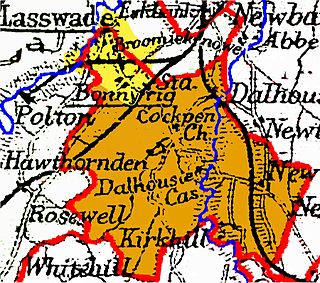
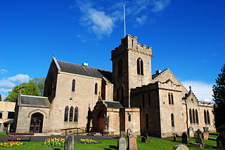
Cockpen is a parish in Midlothian, Scotland, containing at its north-west corner the town of Bonnyrigg, which lies two miles (3.2 km) south-west of Dalkeith. It is bounded on the west and north by the parish of Lasswade, on the east, by Newbattle and on the south by Carrington. It extends about three miles (4.8 km) from north to south and its greatest breadth is about 2+1⁄2 miles (4.0 km).
Scoonie is a settlement and parish in Fife, Scotland, the parish contains the town of Leven. It is bordered on the north by the parishes of Kettle and Ceres, on the east by the parish of Largo, on the south by the parishes of Markinch and Wemyss, and on the west by the parishes of Markinch and Kennoway. It extends about 4+1⁄2 miles north to south. Its width varies between 5⁄8 and 2+3⁄4 mi . The parish is on the coast of the Firth of Forth, with a coastline of about 1+1⁄2 mi (2.4 km) The area of the parish is 4,107 acres.
References
- ↑ National Records of Scotland. "Geography – Background Information – Civil Parishes and Islands" (PDF). Retrieved 19 January 2018.