Related Research Articles
In geography, regions are areas that are broadly divided by physical characteristics, human impact characteristics, and the interaction of humanity and the environment. Geographic regions and sub-regions are mostly described by their imprecisely defined, and sometimes transitory boundaries, except in human geography, where jurisdiction areas such as national borders are defined in law.
Regional planning deals with the efficient placement of land-use activities, infrastructure, and settlement growth across a larger area of land than an individual city or town. Regional planning is related to urban planning as it relates land use practices on a broader scale. It also includes formulating laws that will guide the efficient planning and management of such said regions. Regional planning can be comprehensive by covering various subjects, but it more often specifies a particular subject, which requires region-wide consideration.

Stuttgart Region is an urban agglomeration at the heart of the Stuttgart Metropolitan Region. It consists of the city of Stuttgart and the surrounding districts of Ludwigsburg, Esslingen, Böblingen, Rems-Murr and Göppingen. About 2.7 million inhabitants live in that area (3,700 km2). In fact, with 708 people per square kilometre, the Stuttgart Region is one of the most densely populated areas in Germany. Stuttgart Region is governed by a directly elected parliament.
Assis is a city and a municipality in the southwestern part of the state of São Paulo in Brazil. The population is 105,087 in an area of 460.61 km2. The town was founded on July 5, 1905, and became a municipality in 1917, when it was separated from Platina. It is the largest city of its microregion, and the 2nd of its mesoregion, and is 434 km away from the capital, São Paulo. The town has an annual average temperature of 21,37 °C, annual rainfall 1,441 mm (56.7 in), and the vegetation predominates Mata Atlântica and Cerrado, is then a transition zone of vegetation. Its Human Development Index (HDI) is 0.805, considered high if compared to state and is in 28th place among Brazilian cities.

The Tuchola Forest, also known as Tuchola Pinewoods or Tuchola Conifer Woods, is a large forest complex near the town of Tuchola in northern Poland, which lies between the Brda and Wda Rivers, within the Gdańsk Pomerania region. The largest towns in the area are Czersk and Tuchola.

DVDregion codes are a digital rights management technique designed to allow rights holders to control the international distribution of a DVD release, including its content, release date, and price, all according to the appropriate region.

Brazil is divided into several types and levels of subdivisions.
A microregion was a legally defined area in Brazil consisting of a group of municipalities. They were abolished in 2017 and replaced by "immediate geographic regions". Microregions were grouped together into mesoregions. In theory, Brazilian law provided for member municipalities to cooperate on matters of common interest, but in practice, the divisions were used primarily for statistical purposes by the Brazilian Institute of Geography and Statistics.
A mesoregion was a subdivision of the Brazilian states, grouping together various municipalities in proximity and with common characteristics. They were abolished in 2017 and replaced by "intermediary geographic regions". The mesoregions were created by the Brazilian Institute of Geography and Statistics for statistical purposes and did not, therefore, constitute political or administrative areas. They were further divided into microregions.
Microregion is a designation for territorial entities.

Desterro do Melo is a Brazilian municipality located in the south of the state of Minas Gerais. Its population in 2020 was 2,884 people in a total area of 142 km². The altitude of the municipal seat is 1,085 meters. The city belongs to the mesoregion of Campo das Vertentes and to the microregion of Barbacena.

Miraí is a Brazilian municipality located in the state of Minas Gerais. The city belongs to the mesoregion of Zona da Mata and to the microregion of Muriaé.
A macroregion is a geopolitical subdivision that encompasses several traditionally or politically defined regions or countries. The meaning may vary, with the common denominator being cultural, economical, historical or social similarity within a macroregion. The term is often used in the context of globalization.
Ipaba is a municipality in the state of Minas Gerais in the Southeast region of Brazil.It is located in the Vale do Rio Doce and belongs to the metropolitan collar of the Steel Valley. Its estimated population in 2018 was 18,438 inhabitants.

The Mesoregion of Assis is one of the 15 mesoregions of the São Paulo state, Brazil. It is located at the southwest portion of the state, and has an area of 12,710.210 km² and the seat of mesoregion is in Assis.
In some geomorphological taxonomies, a mesoregion is a natural region of intermediate size.

Kashubian Lake District (314.51) is a mesoregion part of the Eastern Lake District macroregion, the northernmost of all Pomeranian lake districts. Nearly of the lakes lie at a height from 149 to 216 metres above sea level. The mesoregion is largely populated by Kashubians, from which the name of the region originates. However, because Kashubians also live in the nearby mesoregions, the alternative name for the lake district is the Kartuskie Lake District.

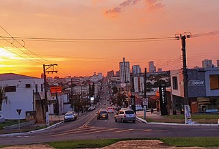
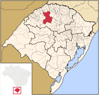
The Microregion of Frederico Westphalen was one of the Microregions of the Rio Grande do Sul state, in Brazil. It belonged to the mesoregion of the Noroeste Rio-Grandense. Its population was estimated by the IBGE to be of 175,391 in 2005, divided in 27 municipalities. Its total area is of 5,182.529 km². The IBGE has since discontinued the microregion system for population tracking, replacing it with the term "immediate geographic region".

Noroeste Rio-Grandense was one of the seven Mesoregions on the state of Rio Grande do Sul in Brazil. It included 216 municipalities grouped in thirteen microregions. The IBGE has since discontinued the microregion system for population tracking, replacing it with the term "immediate geographic region".
The Microregion of Ijuí was one of the Microregions of the Rio Grande do Sul state, in Brazil. It belonged to the mesoregion of the Noroeste Rio-Grandense. Its population was estimated by the IBGE to be of 183.142 inhabitants in 2005, and it was divided in 15 Municipalities. Its total area was of 5.100,402 km². The IBGE has since discontinued the microregion system for population tracking, replacing it with the term "immediate geographic region".
References
- 1 2 Klaus Roth; Ulf Brunnbauer (1 October 2009). Region, Regional Identity and Regionalism in Southeastern Europe. LIT Verlag Münster. pp. 19–. ISBN 978-3-8258-1387-1.
| | This article about geography terminology is a stub. You can help Wikipedia by expanding it. |