Southeast Sulawesi

Last updated
Southeast Sulawesi
Sulawesi Tenggara
Province of Southeast Sulawesi
Coat of arms of Southeast Sulawesi.svg
Motto(s): 
Inae Konasara Iye Pinesara Inae Liasara Iye Pinekasara (Tolaki)
"Whoever respects customs, he will be honored, but whoever does not respect customs, he will not be respected"
South East Sulawesi in Indonesia.svg
Location of Southeast Sulawesi in Indonesia
OpenStreetMap
Southeast Sulawesi
Coordinates: 3°57′00″S122°30′00″E / 3.95000°S 122.50000°E / -3.95000; 122.50000
Founded27 April 1964
Capital
and largest city
Kendari
Government
  BodySoutheast Sulawesi Provincial Government
  GovernorAndap Budhi Revianto (Acting)
  Vice GovernorVacant
Area
  Total38,430.84 km2 (14,838.23 sq mi)
  Rank 24th in Indonesia
Highest elevation2,650 m (8,694 ft)
Population
 (mid 2023 estimate) [1]
  Total2,743,574
  Density71/km2 (180/sq mi)
Demographics
   Ethnic groups 36% Tolaki
26% Butonese
19% Muna
10% Moronene
5.2% Wawonii
3.5% Chinese
0.3% other
   Religion 96% Islam
2.3% Christianity
1.1% Hinduism
0.4% Buddhism
   Languages Indonesian (official)
Buginese (lingua franca)
Cia-Cia, Moronene, Muna, Tolaki, Wakatobi, Wolio (regional)
Time zone UTC+08 (Indonesia Central Time)
GDP (nominal)2022
 - Total Rp 158,761 billion (23rd)
US$ 10.69 billion
US$ 33.36 billion (PPP)
 - Per capita Rp 58.76 million (19th)
US$  3,958
US$ 12,350 (PPP)
 - GrowthIncrease2.svg 5.25%
HDI Increase2.svg 0.728 (High)
HDI rank 17th (2023)
Website sultraprov.go.id

Southeast Sulawesi (Indonesian : Sulawesi Tenggara, often abbreviated to Sultra), is a province on the island of Sulawesi, forming the southeastern peninsula of that island, together with a number of substantial offshore islands such as Buton, Muna, Kabaena and Wawonii (formerly called Wowoni), together with many smaller islands. It is bordered by South Sulawesi and Central Sulawesi to the north, sharing a maritime border with Maluku and North Maluku to the east and East Nusa Tenggara to the south, as well a very narrow maritime border with East Timor to the south. The capital is the city of Kendari, on the east coast of the peninsula.

Contents

The province has no highway road connecting to the rest of the island, and the primary transportation link is a ferry across the Bone Gulf between Watampone (Bone) in South Sulawesi and the port of Kolaka in Southeast Sulawesi.

History

From the seventeenth century until the early twentieth century, the region was the site of the Buton Sultanate  [ zh ] (Butung).[ citation needed ]

Geography

Wakatobi Beach Wakatobi beach 2006.jpg
Wakatobi Beach

The two major mountain ranges in Southeast Sulawesi are the Tanggeasinua Range and the Mekongga Range. [2] The major rivers are the Lalinda, the Lasolo, and the Sampara. [2] [3]

Demographics

The population of the province was 2,232,586 at the 2010 decennial census (1,120,225 males, and 1,110,344 females), [4] increasing to 2,624,875 at the 2020 Census. [5] The official estimate as at mid 2023 was 2,743,574. [1] Konawe Selatan, Konawe, Kolaka and Muna are the four most populous regencies.

A third of the population is centered on Buton and Muna islands off the south coast of Sulawesi, and another 15% live in and around Kendari.

Historical population
YearPop.±%
1971 714,120    
1980 942,302+32.0%
1990 1,349,619+43.2%
1995 1,586,917+17.6%
2000 1,820,379+14.7%
2010 2,232,586+22.6%
2015 2,495,248+11.8%
2020 2,624,875+5.2%
2023 2,743,574+4.5%
Source: Badan Pusat Statistik 2010 to 2023

Religion

Religion in Southeast Sulawesi (2022) [6]

   Islam (95.79%)
   Hinduism (1.89%)
   Protestantism (1.66%)
   Roman Catholic (0.60%)
   Buddhism (0.05%)

Islam is the predominant religion (96.2%). According to the 2021 estimates, 2,560,000 people were Muslims, 50,780 were Hindus, 44,870 were Protestants, 16,180 were Roman Catholics, 1,610 were Buddhists, 113 were Confusians and 63 adhered to Folk religions. [7]

Ethnic groups

The main ethnic groups in Southeast Sulawesi are "Tolaki", "Buton", "Muna" etc.

Administrative divisions

Southeast Sulawesi Province is divided into fifteen regencies (including the five new regencies established in 2013 and 2014) and two autonomous cities.

As at 1995, there were just four regencies within the province - Buton, Kolaka, Konawe and Muna. On 3 August, the city of Kendari was created from part of Konawe Regency, and on 21 June 2001 the city of Bau-Bau was created from part of Buton Regency.

On 25 February 2003, South Konawe Regency was created from part of Konawe Regency. On 18 December 2003, three new regencies were created - Bombana Regency and Wakatobi Regency from parts of Buton Regency, and North Kolaka Regency from part of Kolaka Regency. On 2 January 2007, two new regencies were created - North Konawe Regency from part of Konawe Regency, and North Buton Regency from part of Muna Regency.

In 2013 the Indonesian Government enacted the creation of 11 new Regencies and Municipalities, including the following in Southeast Sulawesi:

Subsequently, on 24 June 2014, the Indonesian Parliament agreed to create three more new regencies, based on consideration of technical, administrative, area, strategic and geopolitic factors: [8]

These regencies and cities are tabulated below, with their areas and their populations at the 2010 Census [4] and the 2020 Census, [5] together with the official estimates as at mid 2023. [1] The table also includes the location of the regency/city headquarters and their Human Development Index.

Kode
Wilayah
Name of
City or
Regency
Area
(km2)
PopulationCapital HDI [9]
2022
Census
2010
Census
2020
Estimate
mid 2023
74.71 Kendari City 270.14289,966345,107351,085Kendari0.845 (Very High)
74.06 Bombana Regency (a)3,293.97139,235150,706163,402 Rumbia 0.668 (Medium)
74.01 Kolaka Regency 2,960.73208,817237,587247,680 Kolaka 0.739 (High)
74.02 Konawe Regency 6,087.68213,038257,011262,439 Unaaha 0.720 (High)
74.08 North Kolaka Regency
(Kolaka Utara)
2,932.25121,340137,659140,488 Lasusua 0.704 (High)
74.11 East Kolaka Regency
(Kolaka Timur)
3,991.78106,415120,699126,754 Tirawuta 0.687 (Medium)
74.09 North Konawe Regency
(Konawe Utara)
5,101.7651,53367,87177,371 Wanggudu 0.711 (High)
74.05 South Konawe Regency
(Konawe Selatan)
4,237.74264,587308,524322,946 Andoolo 0.694 (Medium)
Peninsula Regencies28,876.051,394,9311,625,1641,692,165
74.10 North Buton Regency
(Buton Utara)
1,923.0354,73666,65372,757 Buranga 0.690 (Medium)
74.72 Bau-Bau City 294.98136,991159,248161,280Baubau0.766 (High)
74.04 Buton Regency 1,647.8794,388115,207120,873Pasarwajo0.672 (Medium)
74.15 South Buton Regency
(Buton Seletan)
546.5874,97495,261101,635 Batauga 0.654 (Medium)
74.14 Central Buton Regency (b)
(Buton Tengah)
837.1686,350114,773121,369 Labungkari 0.653 (Medium)
74.03 Muna Regency (c)2,057.69196,645215,527228,639 Raha 0.696 (Medium)
74.13 West Muna Regency
(Muna Barat)
906.2871,63284,59085,706 Laworo 0.662 (Medium)
74.12 Konawe Islands Regency (d)
(Konawe Kepulauan)
867.5828,94437,05041,520 Langara 0.667 (Medium)
74.07 Wakatobi Regency 473.6292,995111,402117,630Wanci (on
Wangi-wangi
Island
)
0.708 (High)
Island Regencies9,554.79837,655999,7111,051,409

Notes

(a) Bombana Regency is mainly peninsula (the areas around Poleang and Rumbia on Sulawesi Island) but partly insular (including most of Kabaena Island).
(b) The Central Buton Regency comprises the southern part of Muna Island and a small southern part of Kabaena Island, but does not include any part of Buton Island.
(c) Under discussion by the Indonesian government in 2013 was a proposal to create an additional municipality of Raha, on Muna Island, but any such proposal is in abeyance and this potential extra municipality is not separated in the table above.
(d) The Konawe Islands Regency comprises Wawonii Island and small offshore islets around it.

Transportation

Airports

Ports

See also

Related Research Articles

<span class="mw-page-title-main">Buton</span> Island in Indonesia

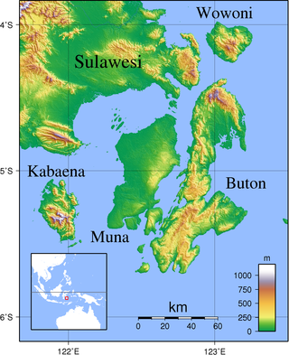
Buton is an island in Indonesia located off the southeast peninsula of Sulawesi. It covers roughly 4,727 square kilometers in area, or about the size of Madura; it is the 129th largest island in the world and Indonesia's 19th largest in area.

<span class="mw-page-title-main">Kendari</span> Capital city of Southeast Sulawesi, Indonesia

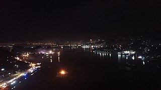
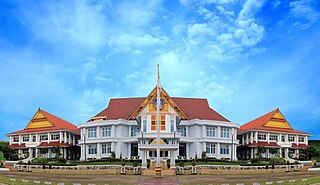
Kendari is the capital city of the Indonesian province of Southeast Sulawesi. It had a population of 289,966 at the 2010 Census and 345,107 at the 2020 census, making it the most populous city in the province, and the fourth most on Sulawesi. The official estimate as at mid 2023 was 351,085 - comprising 176,279 males and 174,806 females. The city covers an area of 270.14 square kilometers (104.30 sq mi), or about 0.7 percent of Southeast Sulawesi's land area. Located on Kendari Bay, it continues to be an important trade center, with the province's main port and airport. It is the economic and educational center of the province, home to various universities and colleges. Kendari has the highest Human Development Index (HDI) in Sulawesi.

<span class="mw-page-title-main">Wakatobi Regency</span> Group of islands in Southeast Sulawesi, Indonesia

Wakatobi Regency is a group of ca. 150 islands forming an administrative regency located in Southeast Sulawesi Province of Indonesia. The four largest islands are Wangi-wangi, Kaledupa, Binongko and Tomia. The capital of the regency is located on Wangi-wangi Island, and was established by virtue of Law of the Republic of Indonesia Number 29 of 2003 dated 18 December 2003. The regency has an area of 473.62 square kilometres and had a population of 92,922 at the 2010 Census and 111,402 at the 2020 Census; the official estimate as at mid 2023 was 117,630.

<span class="mw-page-title-main">Muna Island</span> Island in Southeast Sulawesi, Indonesia

Muna is an island in the Southeast Sulawesi province of Indonesia with an area of 3,219.84 km2 (1,243.19 sq mi) and had a population of 316,293 at the 2010 Census and 368,654 at the 2020 Census. It is just southeast of the island of Sulawesi and west of Buton Island. It currently comprises most of three administrative regencies within the province: Muna Regency, West Muna Regency, and Central Buton Regency.

<span class="mw-page-title-main">Baubau</span> City in Southeast Sulawesi, Indonesia

Baubau is a city in Southeast Sulawesi province, Indonesia. The city is located on the southwest coast of Buton island. Baubau attained city status on 21 June 2001, based on Indonesian Law Number 13, for the year 2001. It covers an area of 294.98 km2, including about 30 km2 of water area, and had a population of 136,991 at the 2010 Census and 159,248 at the 2020 Census; the official estimate as at mid 2023 was 161,280.

<span class="mw-page-title-main">Kabaena</span> Island in Southeast Sulawesi, Indonesia

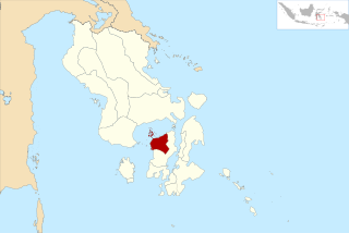
Kabaena or Tokotua is an island in the Flores Sea, Indonesia, off the coast of Sulawesi. Most of it is a part of Bombana Regency within Southeast Sulawesi province, although the southernmost district is administratively part of Central Buton Regency. The island's area is 894.15 km2 and its total population at the 2010 Census was 35,558 and at the 2020 Census was 42,877; the official estimate as at mid 2023 was 47,071.

<span class="mw-page-title-main">Wawonii Island</span> Island in Southeast Sulawesi, Indonesia

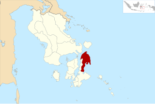
Wawonii is an island in the Banda Sea, Indonesia, off the south east coast of Sulawesi. Its area is 705.71 km2 and at the 2020 Census it had a population of 37,050; the official estimate as at mid 2022 was 38,383. From 2013, it forms a regency of its own within Southeast Sulawesi Province, having previously been a part of Konawe Regency; the new Regency, which comprises the seven districts on Wawonii Island, is named Konawe Islands Regency. The administrative capital of the new Regency is Langara.

<span class="mw-page-title-main">Konawe Regency</span> Regency in Southeast Sulawesi, Indonesia

Konawe Regency is one of the regencies in the province of Southeast Sulawesi, Indonesia. The capital of the regency is Unaaha. The regency was once known as the district of Kendari. The regency had a population of 241,428 at the 2010 Census, but was subsequently reduced by the separation of the offshore island districts as the new Konawe Islands Regency in 2013. It now covers 6,087.68 km2 and had a population of 257,011 at the 2020 Census; the official estimate as at mid 2023 was 262,439. Prior to its division in 2003, 2007 and 2013, Konawe was known as the rice granary of the province of Southeast Sulawesi because half of the province's rice production comes from the Konawe regencies.

<span class="mw-page-title-main">Bombana Regency</span> Regency in Southeast Sulawesi, Indonesia

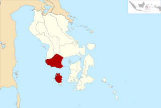
Bombana Regency is a regency of Southeast Sulawesi Province of Indonesia. It consists of part of the southeast peninsula of Sulawesi, together with most of the substantial offshore island of Kabaena to the south. The regency was created on 18 December 2003 from part of Buton Regency. It covers an area of 3,293.97 km2, and had a population on 139,235 at the 2010 Census and 150,706 at the 2020 Census; the official estimate as at mid 2023 was 163,402 - comprising 82,602 males and 80,800 females. The administrative centre lies at the town of Rumbia.

<span class="mw-page-title-main">Buton Regency</span> Regency in Southeast Sulawesi, Indonesia

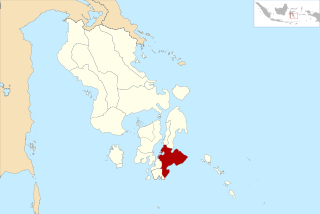
Buton Regency is a regency of Indonesia's Southeast Sulawesi Province, lying entirely on Buton Island. Until 2014 it had an area of 2,681.22 km2, and a population estimated at 276,944. However, in 2014 it was divided into three regencies, with two new regencies being cut out of it; the residual area now is 1,647.87 km2, and the districts in that area contained a population of 94,388 at the 2010 Census while the 2020 Census produced a total of 115,207; the official estimate as at mid 2023 was 120,873 The capital is nominally at Pasarwajo, but the regency's administration is actually undertaken in the city of Baubau on the south-west of the island, although that city is administratively separate from the Regency.

<span class="mw-page-title-main">Kolaka Regency</span> Regency in Southeast Sulawesi, Indonesia

Kolaka Regency is a regency of Southeast Sulawesi Province, Indonesia. It covers an area of 2,960.73 km2 (1,143.14 sq mi) and had a population of 208,817 at the 2010 Census, rising to 237,587 at the 2020 Census; the official estimate as at mid 2023 was 247,680. The principal town lies at Kolaka.

<span class="mw-page-title-main">Muna Regency</span> Regency in Southeast Sulawesi, Indonesia

Muna Regency is a regency of Southeast Sulawesi Province of Indonesia, covering parts of the island of Muna as well as part of the neighbouring Buton Island and smaller islands off its coast. Until 2014 it had an area of 2,945.05 km2, but in that year the western eleven districts of that Regency were split off to form a new West Muna Regency. The reduced regency now covers an area of 2,057.69 km2, and the districts comprising that area had a population of 196,645 at the 2010 Census; the total at the 2020 Census was 215,527, and the official estimate as at mid 2023 was 228,639, comprising 112,624 males and 116,015 females. The principal town lies at Raha, in Katobu District.

<span class="mw-page-title-main">North Buton Regency</span> Regency in Southeast Sulawesi, Indonesia

North Buton Regency is a regency of Indonesia's Southeast Sulawesi Province, which was separated from Buton Regency in accordance with Indonesia's Law Number 14 of 2007. The area of the regency, which covers the north part of Buton Island, is 1,923.03 km2. Its population was 54,736 at the 2010 Census and 66,653 at the 2020 Census; the official estimate as at mid 2023 was 72,757. The administrative capital of the regency is at the town of Buranga, in Bonegunu District.

<span class="mw-page-title-main">North Kolaka Regency</span> Regency in Southeast Sulawesi, Indonesia

North Kolaka Regency is a regency in the northwest part of Southeast Sulawesi province of Indonesia. It was created on 18 December 2003 from the former northern districts of Kolaka Regency. It covers an area of 2,932 km2, and had a population of 121,476 at the 2010 Census, and 137,700 at the 2020 Census; the official estimate as at mid 2023 was 140,488 - comprising 71,995 males and 68,493 females. The principal town lies at Lasusua.

<span class="mw-page-title-main">North Konawe Regency</span> Regency in Southeast Sulawesi, Indonesia

North Konawe Regency is a regency of Southeast Sulawesi Province, Indonesia. It was formed on 2 January 2007 by splitting off seven of the northern districts of Konawe Regency to form a new North Konawe Regency. It is surrounded on all landward sides by the remaining area of the Konawe Regency, except in the northeast, where it borders on Sulawesi Tengah Province. It covers a land area of 5,101.76 km2. It had a population of 51,447 at the 2010 Census and 67,871 at the 2020 Census; the official estimate as at mid 2023 was 77,391 - comprising 39,823 males and 37,568 females. The principal town lies at Asera.

<span class="mw-page-title-main">Konawe Islands Regency</span> Regency in Southeast Sulawesi, Indonesia

Konawe Islands Regency is an insular regency in the province of Southeast Sulawesi, Indonesia, established on 15 May 2013 from that former insular part of Konawe Regency which consisted of the seven districts comprising Wawonii Island. It covers an area of 867.58 km2, and had a population of 28,944 at the 2010 Census and 37,050 at the 2020 Census; the official estimate as at mid 2023 was 41,520. The administrative centre lies at the town of Langara.

<span class="mw-page-title-main">West Muna Regency</span> Regency in Southeast Sulawesi, Indonesia

West Muna Regency is a new regency of Southeast Sulawesi Province of Indonesia,and is situated in the northwest corner of Muna Island and smaller ilsands of its coast. It was established under Act No.14 of 2014, dated 23 July 2014 by separation from the Muna Regency. It covers an area of 906.28 km2, and the districts comprising it had a population of 71,632 at the 2010 Census; the 2020 Census resulted in a population of 84,590, and the official estimate as at mid 2022 was 85,706, comprising 42,242 males and 43,464 females. The administrative centre lies at Laworo in the Tiworo Islands District.

<span class="mw-page-title-main">Central Buton Regency</span> Regency in Southeast Sulawesi, Indonesia

Central Buton Regency is a new regency of Southeast Sulawesi established by separation from Buton Regency under Act No.15 of 2014, dated 23 July 2014. It covers an area of 837.16 km2 comprising the southern parts of Muna Island and Kabaena Island, together with several small offshore islands adjacent to these two main islands, but with no territory located on Buton Island. It had a population of 86,112 at the 2010 Census and 114,773 at the 2020 Census; the official estimate as at mid 2023 was 121,369. The administrative centre lies at Labungkari in Lakudo District.

<span class="mw-page-title-main">South Buton Regency</span> Regency in Southeast Sulawesi, Indonesia

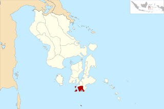
South Buton Regency is a regency located on Buton Island in Southeast Sulawesi Province of Indonesia. This regency was formed from the southern part of Buton Regency, from which it was separated by Act No.16 of 2014, dated 23 July 2014. It covers an area of 546.58 km2, and the population of the districts now comprising the new regency was 74,974 at the 2010 Census and 95,261 at the 2020 Census; the official estimate as at mid 2023 was 101,635. The regency capital is located in Batauga.

References

  1. 1 2 3 Badan Pusat Statistik, Jakarta, 28 February 2024, Provinsi Sulawesi Tenggara Dalam Angka 2024 (Katalog-BPS 1102001.74)
  2. 1 2 "Tanggeasinua Mountains". Encyclopædia Britannica. Archived from the original on 2 April 2015.
  3. TPC M-12 AG, Indonesia (Map) (first ed.). 1:500,000. Director of Military Survey, Ministry of Defence, United Kingdom. 1972.
  4. 1 2 Biro Pusat Statistik, Jakarta, 2011.
  5. 1 2 Badan Pusat Statistik, Jakarta, 2021.
  6. "Jumlah Penduduk Menurut Agama" (in Indonesian). Ministry of Religious Affairs. 31 August 2022. Retrieved 29 October 2023. Muslim 241 Million (87), Christianity 29.1 Million (10.5), Hindu 4.69 million (1.7), Buddhist 2.02 million (0.7), Folk, Confucianism, and others 192.311 (0.1), Total 277.749.673 Million
  7. Badan Pusat Statistik, Jakarta, 2022.
  8. Riza Harahap (June 24, 2014). "DPR setujui tiga kabupaten baru di Sultra".
  9. "BPS Prov. Sulawesi Tenggara". sultra.bps.go.id. Retrieved 2024-01-06.