Southeast Sulawesi is a province on the island of Sulawesi, forming the southeastern peninsula of that island, together with a number of substantial offshore islands such as Buton, Muna, Kabaena and Wawonii, together with many smaller islands. The capital is the city of Kendari, on the east coast of the peninsula.

Pandeglang Regency is a regency of Banten province, Indonesia. It is mainly located on the west and south coasts of the island of Java, and is the most westerly regency on Java Island, but it also includes a number of offshore islands such as Panaitan, Deli and Tinjil. The regency has an area of 2,746.81 km2, and an population at the 2010 Census of 1,149,610, rising to 1,272,687 at the 2020 Census; the official estimate as at mid 2021 was 1,288,314. The regency seat is the town of Pandeglang.

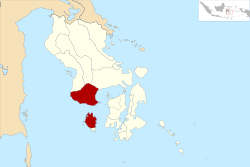
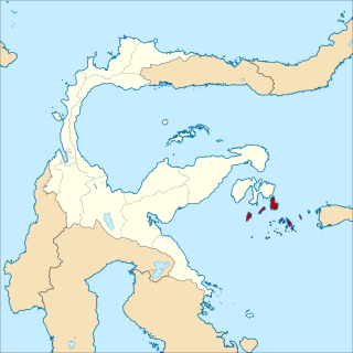
Kabaena or Tokotua is an island in the Flores Sea, Indonesia, off the coast of Sulawesi. Most of it is a part of Bombana Regency within Southeast Sulawesi province, although the southernmost district is administratively part of Central Buton Regency. The island's area is 891.36 km2 and its total population at the 2010 Census was 35,558 and at the 2020 Census was 42,877; the official estimate as at mid 2021 was 43,464.

Buol Regency is a regency of Central Sulawesi Province of Indonesia. It covers an area of 4,043.57 km2, and had a population of 132,330 at the 2010 Census; and 145,254 at the 2020 Census; the official estimate as at mid 2021 was 146,628. The administrative centre is the town of Buol, in Biau District.

Yapen Islands Regency is a regency (kabupaten) in Papua Province of eastern Indonesia. It covers an area of 2,432.49 km2 (939.19 sq mi), and had a population of 82,951 at the 2010 Census and 112,676 at the 2020 Census. The official estimate as at mid 2021 was 114,210. It comprises an archipelago which lies in Cenderawasih Bay off the north coast of Western New Guinea.

East Luwu Regency is the most easterly of the twenty-one regencies in South Sulawesi Province of Indonesia. Malili is the capital of East Luwu Regency. The population of East Luwu Regency was 243,069 at the 2010 Census and 296,741 at the 2020 Census.
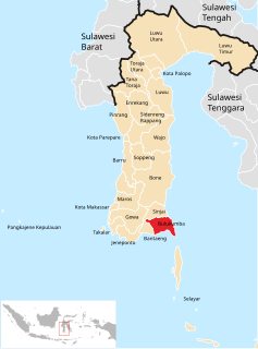
Bulukumba Regency is a regency in the southeast corner of South Sulawesi Province, Indonesia. It covers an area of 1,154.58 km2, and had a population of 394,757 at the 2010 Census and 437,607 at the 2020 Census. The official estimate for mid 2021 was 440,090. The town of Ujung Bulu is its capital.

Pasangkayu Regency is one of the five regencies which comprise West Sulawesi Province, Indonesia, on the island of Sulawesi. It covers an area of 3,043.75 km2 and had a population of 134,303 at the 2010 Census and 188,861 at the 2020 Census. The official estimate as at mid 2021 was 193,098. The town of Pasangkayu is the capital of the regency, and its only urban community (kelurahan).

Majene Regency is one of the six regencies which comprise West Sulawesi Province, Indonesia, on the island of Sulawesi. The town of Majene in the far south of the regency is the administrative capital, and consists of two administrative districts - Banggae and Banggae Timur. The population of Majene Regency was 151,197 at the 2010 Census and 174,407 at the 2020 Census. The official estimate as at mid 2021 was 175,788.
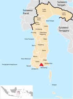
Bantaeng Regency is a regency of South Sulawesi Province in Indonesia. It covers an area of 395.83 km2 and had a population of 176,984 at the 2010 Census, rising to 196,716 at the 2020 Census. The official estimate as at mid 2021 was 197,886. The administrative centre is the town of Bantaeng, which lies on the south coast of the southern peninsula of Sulawesi island.
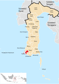
Takalar Regency is a regency of South Sulawesi Province, Indonesia. It covers an area of 566.51 km2 and had a population of 269,603 at the 2010 census and 300,853 at the 2020 census; the official estimate for mid 2021 was 302,695. The entire regency lies within the official metropolitan area of the city of Makassar. The principal towns are at Galesong and Takalar, but the administrative centre is at Pattallassang.
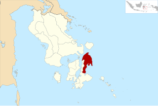
Buton Regency is a regency of Indonesia's Southeast Sulawesi Province, lying entirely on Buton Island. Until 2014 it had an area of 2,681.22 km2, and a population estimated at 276,944. However, in 2014 it was divided into three regencies, with two new regencies being cut out of it; the residual area now is 1,648.04 km2, and the districts in that area contained a population of 94,388 at the 2010 Census while the 2020 Census produced a total of 115,207.
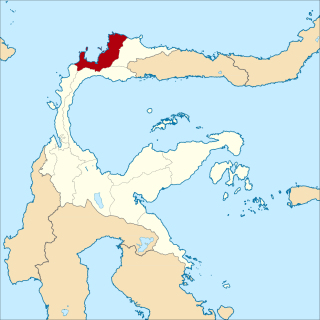
North Buton Regency is a regency of Indonesia's Southeast Sulawesi Province, which was separated from Buton Regency in accordance with Indonesia's Law Number 14 of 2007. The area of the regency, which covers the north part of Buton Island, is 1,923.03 km2. Its population was 54,736 at the 2010 Census and 66,653 at the 2020 Census. The principal town lies at Buranga.

North Kolaka Regency is a regency in the northwest part of Southeast Sulawesi province of Indonesia. It covers an area of 2,924.46 km2, and had a population of 121,476 at the 2010 Census, and 137,700 at the 2020 Census. The principal town lies at Lasusua.

South Konawe Regency is a regency of Southeast Sulawesi Province, Indonesia. It covers an area of 4,200.89 km2 and had a population of 264,587 at the 2010 Census and of 308,524 at the 2020 Census. The official estimate as at mid 2021 was 312,674. The administrative centre is in the town of Andoolo.

The Banggai Archipelago is a group of islands, which are located at the far eastern end of Central Sulawesi, Indonesia. It makes up a regency (kabupaten) of Central Sulawesi Province of Indonesia, created in 1999 by splitting the existing Banggai Regency into a new Banggai Regency situated on the mainland of Sulawesi and a Banggai Islands Regency then comprising the entire archipelago. In December 2014 a further splitting of the Regency was the removal of the more southerly seven districts to form a new Banggai Laut Regency.
Tolitoli Regency is a regency of Central Sulawesi Province of Indonesia. It covers an area of 4,079.77 km2 and had a population of 211,296 at the 2010 Census and 225,154 at the 2020 Census; the official estimate as at mid 2021 was 226,796, comprising 115,735 male and 111,061 female inhabitants. It was previously part of another regency together with the current Buol Regency, named Buol Tolitoli Regency, but this was split in early 2000 after rapid decentralization of the Indonesian government. Its regency seat is located at Tolitoli, which is a port town and where its population is concentrated.

South Minahasa Regency is a regency in North Sulawesi, Indonesia. Its capital is Amurang. It covers an area of 1,456.46 km2, and had a population of 195,553 at the 2010 Census; this had risen to 236,463 at the 2020 Census. It was originally part of the Minahasa Regency until it was established as a separate regency on 25 February 2003. In turn, a Southeast Minahasa Regency was established as a separate regency from part of the South Minahasa Regency on 2 January 2007.
Banggai Laut Regency is a regency in the province of Central Sulawesi, Indonesia. The regency was established on 14 December 2012, partitioned from the Banggai Islands Regency. It comprises the main island of Banggai itself, the islands of Labobo and Bangkurung to the southwest of Banggai Island, and the numerous small Bokan Islands to the southeast. It covers a land area of 725.67 km2, and had a population of 70,435 at the 2020 Census; the official estimate as at mid 2021 was 70,872.

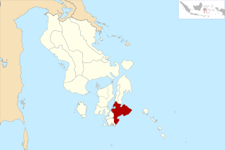
Central Buton Regency is a new regency of Southeast Sulawesi established by separation from Buton Regency under Act No.15 of 2014, dated 23 July 2014. It covers an area of 837.08 km2 comprising the southern parts of Muna Island and Kabaena Island, together with several small offshore islands adjacent to the two main islands. It had a population of 86,112 at the 2010 Census and 114,773 at the 2020 Census; the official estimate as at mid 2021 was 116,599. The administrative centre lies at Labungkari.