Tropical rainforest climate

Last updated
Worldwide zones of tropical rainforest climate (Af). Koppen-Geiger Map v2 Af 1991-2020.svg
Worldwide zones of tropical rainforest climate (Af).

A tropical rainforest climate is a tropical climate sub-type usually found within 10 to 15 degrees latitude of the equator. There are some other areas at higher latitudes, such as Bermuda, the coast of southernmost Florida, United States (Fort Lauderdale, West Palm Beach), and Okinawa, Japan that fall into the tropical rainforest climate category. They experience high mean annual temperatures, small temperature ranges, and rain that falls throughout the year. Regions with this climate are typically designated Af by the Köppen climate classification. A tropical rainforest climate is typically hot, very humid, and wet with no dry season.

Contents

Description

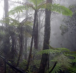
Borneo, with the typical vegetation of tropical forests. Cloud forest mount kinabalu.jpg
Borneo, with the typical vegetation of tropical forests.
Amazon rainforest, Manaus, Brazil. Amazon Manaus forest.jpg
Amazon rainforest, Manaus, Brazil.

Tropical rainforests have a type of tropical climate (at least 18 C or 64.4 F in their coldest month) in which there is no dry season—all months have an average precipitation value of at least 60 mm (2.4 in). There are no distinct wet or dry seasons as rainfall is high throughout the months. One day in a tropical rainforest climate can be very similar to the next, while the change in temperature between day and night may be larger than the average change in temperature during the year. [1]

Equatorial climates and tropical trade-wind climates

When tropical rainforest climates are more dominated by the Intertropical Convergence Zone (ITCZ) than the trade winds (and with no or rare cyclones), so usually located near the equator, they are also called equatorial climates. Otherwise, when they are more dominated by the trade winds than the ITCZ, they are called tropical trade-wind climates. In pure equatorial climates, the atmospheric pressure is almost constantly low so the horizontal pressure gradient is low. Consequently, the winds are rare and usually weak (except sea and land breezes in coastal areas) while in tropical trade-wind climates, often located at higher latitudes than the equatorial climates, the wind is almost permanent which incidentally explains why rainforest formations are impoverished compared to those of equatorial climates due to their necessary resistance to strong winds accompanying tropical disturbances. [2] [3]

Cities with tropical rainforest climates

Asia

Oceania

Africa

Americas

Paramaribo, Suriname
Climate chart (explanation)
J
F
M
A
M
J
J
A
S
O
N
D
 
 
200
 
 
30
22
 
 
140
 
 
30
22
 
 
150
 
 
30
22
 
 
210
 
 
31
22
 
 
290
 
 
30
23
 
 
290
 
 
31
22
 
 
230
 
 
31
22
 
 
170
 
 
32
23
 
 
90
 
 
32
23
 
 
90
 
 
33
23
 
 
120
 
 
32
23
 
 
180
 
 
30
22
Average max. and min. temperatures in °C
Precipitation totals in mm
Source:
Imperial conversion
JFMAMJJASOND
 
 
7.9
 
 
86
72
 
 
5.5
 
 
86
72
 
 
5.9
 
 
86
72
 
 
8.3
 
 
88
72
 
 
11
 
 
86
73
 
 
11
 
 
88
72
 
 
9.1
 
 
88
72
 
 
6.7
 
 
90
73
 
 
3.5
 
 
90
73
 
 
3.5
 
 
91
73
 
 
4.7
 
 
90
73
 
 
7.1
 
 
86
72
Average max. and min. temperatures in °F
Precipitation totals in inches
Mbandaka, DR Congo
Climate chart (explanation)
J
F
M
A
M
J
J
A
S
O
N
D
 
 
80
 
 
31
19
 
 
100
 
 
32
20
 
 
150
 
 
32
20
 
 
140
 
 
31
20
 
 
130
 
 
31
20
 
 
110
 
 
30
19
 
 
100
 
 
30
17
 
 
100
 
 
29
17
 
 
200
 
 
30
19
 
 
210
 
 
30
19
 
 
190
 
 
30
19
 
 
120
 
 
30
19
Average max. and min. temperatures in °C
Precipitation totals in mm
Source:
Imperial conversion
JFMAMJJASOND
 
 
3.1
 
 
88
66
 
 
3.9
 
 
90
68
 
 
5.9
 
 
90
68
 
 
5.5
 
 
88
68
 
 
5.1
 
 
88
68
 
 
4.3
 
 
86
66
 
 
3.9
 
 
86
63
 
 
3.9
 
 
84
63
 
 
7.9
 
 
86
66
 
 
8.3
 
 
86
66
 
 
7.5
 
 
86
66
 
 
4.7
 
 
86
66
Average max. and min. temperatures in °F
Precipitation totals in inches
Pontianak, Indonesia
Climate chart (explanation)
J
F
M
A
M
J
J
A
S
O
N
D
 
 
260
 
 
32
23
 
 
215
 
 
33
23
 
 
254
 
 
33
23
 
 
292
 
 
33
23
 
 
256
 
 
33
23
 
 
212
 
 
33
23
 
 
201
 
 
33
22
 
 
180
 
 
33
23
 
 
295
 
 
33
23
 
 
329
 
 
33
23
 
 
400
 
 
32
23
 
 
302
 
 
32
22
Average max. and min. temperatures in °C
Precipitation totals in mm
Source:
Imperial conversion
JFMAMJJASOND
 
 
10
 
 
90
73
 
 
8.5
 
 
91
73
 
 
10
 
 
91
73
 
 
11
 
 
92
74
 
 
10
 
 
91
74
 
 
8.3
 
 
92
74
 
 
7.9
 
 
91
72
 
 
7.1
 
 
92
73
 
 
12
 
 
91
73
 
 
13
 
 
91
73
 
 
16
 
 
90
73
 
 
12
 
 
90
72
Average max. and min. temperatures in °F
Precipitation totals in inches
Kuala Lumpur, Malaysia
Climate chart (explanation)
J
F
M
A
M
J
J
A
S
O
N
D
 
 
227
 
 
33
24
 
 
193
 
 
33
24
 
 
270
 
 
34
25
 
 
302
 
 
34
25
 
 
230
 
 
34
25
 
 
146
 
 
33
25
 
 
165
 
 
33
24
 
 
174
 
 
33
25
 
 
220
 
 
33
24
 
 
284
 
 
33
24
 
 
356
 
 
32
24
 
 
281
 
 
32
24
Average max. and min. temperatures in °C
Precipitation totals in mm
Source: Monthly Statistical Bulletin Sarawak
Imperial conversion
JFMAMJJASOND
 
 
8.9
 
 
91
75
 
 
7.6
 
 
92
75
 
 
11
 
 
93
76
 
 
12
 
 
93
76
 
 
9.1
 
 
92
77
 
 
5.7
 
 
92
77
 
 
6.5
 
 
91
76
 
 
6.9
 
 
91
76
 
 
8.7
 
 
91
76
 
 
11
 
 
91
76
 
 
14
 
 
90
75
 
 
11
 
 
90
75
Average max. and min. temperatures in °F
Precipitation totals in inches
Davao, Philippines
Climate chart (explanation)
J
F
M
A
M
J
J
A
S
O
N
D
 
 
140
 
 
31
23
 
 
109
 
 
31
23
 
 
108
 
 
32
24
 
 
125
 
 
33
24
 
 
159
 
 
33
25
 
 
187
 
 
32
24
 
 
165
 
 
32
24
 
 
170
 
 
32
24
 
 
170
 
 
32
24
 
 
175
 
 
32
24
 
 
138
 
 
32
24
 
 
113
 
 
31
24
Average max. and min. temperatures in °C
Precipitation totals in mm
Source:
Imperial conversion
JFMAMJJASOND
 
 
5.5
 
 
87
74
 
 
4.3
 
 
88
74
 
 
4.3
 
 
90
74
 
 
4.9
 
 
91
76
 
 
6.2
 
 
91
76
 
 
7.4
 
 
89
76
 
 
6.5
 
 
89
75
 
 
6.7
 
 
89
75
 
 
6.7
 
 
89
75
 
 
6.9
 
 
90
75
 
 
5.4
 
 
90
75
 
 
4.4
 
 
89
75
Average max. and min. temperatures in °F
Precipitation totals in inches
Quibdó, Colombia
Climate chart (explanation)
J
F
M
A
M
J
J
A
S
O
N
D
 
 
579
 
 
30
23
 
 
505
 
 
30
23
 
 
526
 
 
30
23
 
 
655
 
 
31
23
 
 
776
 
 
31
23
 
 
762
 
 
31
23
 
 
803
 
 
31
23
 
 
852
 
 
31
23
 
 
702
 
 
31
23
 
 
654
 
 
30
23
 
 
728
 
 
30
23
 
 
589
 
 
30
23
Average max. and min. temperatures in °C
Precipitation totals in mm
Source:
Imperial conversion
JFMAMJJASOND
 
 
23
 
 
86
73
 
 
20
 
 
86
74
 
 
21
 
 
87
74
 
 
26
 
 
87
74
 
 
31
 
 
88
74
 
 
30
 
 
88
73
 
 
32
 
 
88
73
 
 
34
 
 
88
73
 
 
28
 
 
87
73
 
 
26
 
 
87
73
 
 
29
 
 
86
73
 
 
23
 
 
85
73
Average max. and min. temperatures in °F
Precipitation totals in inches

See also

Related Research Articles

<span class="mw-page-title-main">Geography of Brunei</span>

Brunei is a country in Southeast Asia, bordering the South China Sea and East Malaysia. Its geographical coordinates are 4°30′N114°40′E. The country is small with a total size of 5,765 km2 (2,226 sq mi). It is larger in size than Trinidad and Tobago. It is close to vital sea lanes through the South China Sea linking the Indian and Pacific Oceans. The country has two parts physically separated by Malaysia, making it almost an enclave within Malaysia.

The Global 200 is the list of ecoregions identified by the World Wide Fund for Nature (WWF), the global conservation organization, as priorities for conservation. According to WWF, an ecoregion is defined as a "relatively large unit of land or water containing a characteristic set of natural communities that share a large majority of their species dynamics, and environmental conditions". For example, based on their levels of endemism, Madagascar gets multiple listings, ancient Lake Baikal gets one, and the North American Great Lakes get none.

<span class="mw-page-title-main">Tropical and subtropical moist broadleaf forests</span> Habitat type defined by the World Wide Fund for Nature

Tropical and subtropical moist broadleaf forests (TSMF), also known as tropical moist forest, is a subtropical and tropical forest habitat type defined by the World Wide Fund for Nature.

<span class="mw-page-title-main">Intertropical Convergence Zone</span> Meteorological phenomenon

The Intertropical Convergence Zone, known by sailors as the doldrums or the calms because of its monotonous windless weather, is the area where the northeast and the southeast trade winds converge. It encircles Earth near the thermal equator though its specific position varies seasonally. When it lies near the geographic equator, it is called the near-equatorial trough. Where the ITCZ is drawn into and merges with a monsoonal circulation, it is sometimes referred to as a monsoon trough.

<span class="mw-page-title-main">Köppen climate classification</span> Climate classification system

The Köppen climate classification divides Earth climates into five main climate groups, with each group being divided based on patterns of seasonal precipitation and temperature. The five main groups are A (tropical), B (arid), C (temperate), D (continental), and E (polar). Each group and subgroup is represented by a letter. All climates are assigned a main group. All climates except for those in the E group are assigned a seasonal precipitation subgroup. For example, Af indicates a tropical rainforest climate. The system assigns a temperature subgroup for all groups other than those in the A group, indicated by the third letter for climates in B, C, D, and the second letter for climates in E. For example, Cfb indicates an oceanic climate with warm summers as indicated by the ending b. Climates are classified based on specific criteria unique to each climate type.

<span class="mw-page-title-main">Trade winds</span> Equatorial east-to-west prevailing winds

The trade winds or easterlies are permanent east-to-west prevailing winds that flow in the Earth's equatorial region. The trade winds blow mainly from the northeast in the Northern Hemisphere and from the southeast in the Southern Hemisphere, strengthening during the winter and when the Arctic oscillation is in its warm phase. Trade winds have been used by captains of sailing ships to cross the world's oceans for centuries. They enabled European colonization of the Americas, and trade routes to become established across the Atlantic Ocean and the Pacific Ocean.

<span class="mw-page-title-main">North Equatorial Current</span> Current in the Pacific and Atlantic Oceans

The North Equatorial Current (NEC) is a westward wind-driven current mostly located near the equator, but the location varies from different oceans. The NEC in the Pacific and the Atlantic is about 5°-20°N, while the NEC in the Indian Ocean is very close to the equator. It ranges from the sea surface down to 400 m in the western Pacific.

<i>Cleistanthus</i> Genus of flowering plants

Cleistanthus is a plant genus of the family Phyllanthaceae, tribe Bridelieae, first described as a genus in 1848. It is widespread in much of the Old World Tropics in Asia, Africa, Australia, and various oceanic islands. Cleistanthus collinus is known for being toxic and may be the agent of homicides or suicides.

<i>Drypetes</i> Genus of flowering plants

Drypetes is a plant genus of the family Putranjivaceae, in the order Malpighiales.

<span class="mw-page-title-main">Convergence zone</span> Region in the atmosphere

A convergence zone in meteorology is a region in the atmosphere where two prevailing flows meet and interact, usually resulting in distinctive weather conditions. This causes a mass accumulation that eventually leads to a vertical movement and to the formation of clouds and precipitation. Large-scale convergence, called synoptic-scale convergence, is associated with weather systems such as baroclinic troughs, low-pressure areas, and cyclones. The large-scale convergence zone formed over the equator, the Intertropical Convergence Zone, has condensed and intensified as a result of the global increase in temperature. Small-scale convergence will give phenomena from isolated cumulus clouds to large areas of thunderstorms.

<span class="mw-page-title-main">Geography of South America</span>

The geography of South America contains many diverse regions and climates. Geographically, South America is generally considered a continent forming the southern portion of the landmass of the Americas, south and east of the Colombia–Panama border by most authorities, or south and east of the Panama Canal by some. South and North America are sometimes considered a single continent or supercontinent, while constituent regions are infrequently considered subcontinents.

<span class="mw-page-title-main">Hadley cell</span> Tropical atmospheric circulation feature

The Hadley cell, also known as the Hadley circulation, is a global-scale tropical atmospheric circulation that features air rising near the equator, flowing poleward near the tropopause at a height of 12–15 km (7.5–9.3 mi) above the Earth's surface, cooling and descending in the subtropics at around 25 degrees latitude, and then returning equatorward near the surface. It is a thermally direct circulation within the troposphere that emerges due to differences in insolation and heating between the tropics and the subtropics. On a yearly average, the circulation is characterized by a circulation cell on each side of the equator. The Southern Hemisphere Hadley cell is slightly stronger on average than its northern counterpart, extending slightly beyond the equator into the Northern Hemisphere. During the summer and winter months, the Hadley circulation is dominated by a single, cross-equatorial cell with air rising in the summer hemisphere and sinking in the winter hemisphere. Analogous circulations may occur in extraterrestrial atmospheres, such as on Venus and Mars.

A tropical marine climate is a tropical climate that is primarily influenced by the ocean. It is usually experienced by islands and coastal areas 10° to 20° north and south of the equator. There are two main seasons in a tropical marine climate: the wet season and the dry season. The annual rainfall is 1000 to over 1500 mm. The temperature ranges from 20 to 35 °C. Under the Köppen climate classification, a "tropical marine climate" would fall under Af or Am, tropical rainforest or tropical monsoon climate. The trade winds blow all year round and are moist, as they pass over warm seas. These climatic conditions are found, for example, across the Caribbean, the eastern coasts of Brazil, Madagascar and Queensland; and many islands in tropical waters.

<span class="mw-page-title-main">Tropical savanna climate</span> Climate subtype

Tropical savanna climate or tropical wet and dry climate is a tropical climate sub-type that corresponds to the Köppen climate classification categories Aw and As. The driest month has less than 60 mm (2.4 in) of precipitation and also less than mm of precipitation.

<span class="mw-page-title-main">Tropical monsoon climate</span> Climate subtype in the Köppen climate classification system

An area of tropical monsoon climate is a tropical climate subtype that corresponds to the Köppen climate classification category Am. Tropical monsoon climates have monthly mean temperatures above 18 °C (64 °F) in every month of the year and a dry season. The tropical monsoon climate is the intermediate climate between the wet Af and the drier Aw.

The Tropical Atlantic SST Dipole refers to a cross-equatorial sea surface temperature (SST) pattern that appears dominant on decadal timescales. It has a period of about 12 years, with the SST anomalies manifesting their most pronounced features around 10–15 degrees of latitude off of the Equator. It is also referred to as the interhemispheric SST gradient or the Meridional Atlantic mode.

There are a number of explanations of the asymmetry of the Intertropical Convergence Zone (ITCZ), known by sailors as the Doldrums.

The Tropical Atlantic Variability (TAV) is influenced by internal interaction and external effects. TAV can be discussed in different time scales: seasonal and interannual.

References

  1. McKnight, Tom L; Hess, Darrel (2000). "Climate Zones and Types". Physical Geography: A Landscape Appreciation. Upper Saddle River, NJ: Prentice Hall. pp.  205–8. ISBN   978-0-13-020263-5.
  2. Pierre Estienne Alain Godard (1998) [1970]. Climatologie. Paris: Armand Colin. pp. 309 and 316. ISBN   9791037636157. OCLC   757354683.
  3. Seidel, Dian J.; Fu, Qiang; Randel, William J.; Reichler, Thomas J. (January 2008). "Widening of the tropical belt in a changing climate". Nature Geoscience. 1 (1): 21–24. Bibcode:2008NatGe...1...21S. doi:10.1038/ngeo.2007.38. ISSN   1752-0908.
  4. "Nicobar Islands rain forests". Terrestrial Ecoregions. World Wildlife Fund.