Villa Tunari

Last updated
Villa Tunari
Tunarimarka
Villatunaripanorama.jpg
Villa Tunari with Espíritu Santo River (upper right) and San Mateo River
Bolivia adm location map.svg
Red pog.svg
Villa Tunari
Location within Bolivia
Coordinates: 16°58′S65°25′W / 16.967°S 65.417°W / -16.967; -65.417
CountryBandera de Bolivia (Estado).svg  Bolivia
State Cochabamba Department
Province Chapare Province
Municipality Villa Tunari Municipality
Canton Villa Tunari Canton
Population
 (2012)
  Total3,213
Time zone UTC-4 (BOT)

Villa Tunari or Tunari is a location in the department of Cochabamba, Bolivia. It is the seat of the Villa Tunari Municipality, the third municipal section of the Chapare Province. According to the census 2012 the population was 3,213 in the town which is an increment from 2,510 registered during the 2001 census. [1]

Contents

Villa Tunari has several parks located nearby including Parque Machía and Carrasco National Park. Parque Machía is home to one of three wildlife centers maintained by Comunidad Inti Wara Yassi and supported by international volunteers. Villa Tunari is famous among tourists due to the tropical weather and due to nearby national parks. Recently the town gained important infrastructure due to the tourist industry and because a new paper industry seated near to the town.

Population

The population increased moderately from 2001 census because little rural communities were settled near to the town. Most of people are quechua descent and the main spoken languages are Spanish and Quechua.

yearPopulationReference
19921 597census [2]
20012 510census [3]
20123 210census [4]

Geography

Villa Tunari - about 160km to the northeast of Cochabamba - is located at the final folds of the Andean foothills of central Bolivia, a transition zone where steep orographies meet the extensive llanos region of Bolivia - itself a mosaic of savanna, rainforest, and monsoonal landscapes. The general vicinity of Villa Tunari is predominantly tropical rainforest, of the Southwestern Amazonian variety. Precipitation in this region is plentiful, with some of the highest annual rainfall trends in the country. Villa Tunari is a popular tourist destination thanks to its dramatic proximity to the central Andes, and its rich ecological surroundings. Under the Köppen climate classification, Villa Tunari has a tropical rainforest climate with a lengthy rainy season, a shorter dry season and ample precipitation throughout the year. Villa Tunari experiences the highest recorded annual precipitation in Bolivia, and frequently exceeds 5,000mm of precipitation per year.

Climate data for Villa Tunari
MonthJanFebMarAprMayJunJulAugSepOctNovDecYear
Record high °C (°F)37
(99)
37
(99)
37
(99)
40
(104)
42
(108)
39
(102)
38
(100)
40
(104)
37
(99)
40
(104)
38
(100)
37
(99)
42
(108)
Average high °C (°F)30.9
(87.6)
30.8
(87.4)
31.1
(88.0)
30.6
(87.1)
29.1
(84.4)
28.4
(83.1)
29.0
(84.2)
30.8
(87.4)
30.6
(87.1)
32.6
(90.7)
31.9
(89.4)
31.4
(88.5)
31.4
(88.5)
Daily mean °C (°F)26.9
(80.4)
27.0
(80.6)
27.1
(80.8)
26.1
(79.0)
24.5
(76.1)
22.8
(73.0)
22.6
(72.7)
24.0
(75.2)
24.7
(76.5)
26.7
(80.1)
26.9
(80.4)
27.0
(80.6)
25.5
(77.9)
Average low °C (°F)22.9
(73.2)
23.2
(73.8)
23.1
(73.6)
21.6
(70.9)
19.9
(67.8)
17.1
(62.8)
16.2
(61.2)
17.2
(63.0)
18.9
(66.0)
20.9
(69.6)
22.0
(71.6)
22.6
(72.7)
20.5
(68.9)
Record low °C (°F)15
(59)
16
(61)
13
(55)
12
(54)
8
(46)
7
(45)
3
(37)
7
(45)
10
(50)
12
(54)
12
(54)
13
(55)
3
(37)
Average precipitation mm (inches)807.8
(31.80)
944.1
(37.17)
821.5
(32.34)
456.7
(17.98)
416.2
(16.39)
177.5
(6.99)
135.7
(5.34)
196.3
(7.73)
235.7
(9.28)
393.0
(15.47)
744.7
(29.32)
830.8
(32.71)
6,159.9
(242.52)
Source 1: Sistema de Clasificación Bioclimática Mundial [5]
Source 2: SENAMHI [6]

Sports

The Estadio Olímpico Bicentenario de Villa Tunari is located in Villa Tunari. The 25,000-capacity stadium is used for football matches. It opened on 8 September 2018.

See also

Related Research Articles

Cochabamba Department Department of Bolivia

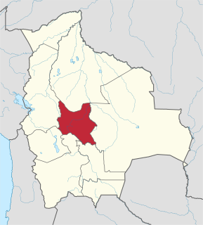
Cochabamba, from Quechua qucha or qhucha, meaning "lake", pampa meaning "plain", is one of the nine departments of Bolivia. It is known to be the "granary" of the country because of its variety of agricultural products from its geographical position. It has an area of 55,631 km2. Its population in the 2012 census was 1,758,143. Its capital is the city of Cochabamba, known as the "City of Eternal Spring" and "The Garden City" because of its spring-like temperatures all year.

Chapare Province

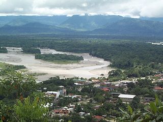
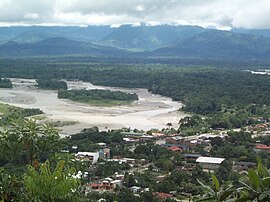
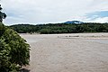
Chapare, also called The Chapare and is pronounced Cha-pa-reh, is a rural province in the northern region of Cochabamba Department in central Bolivia. The majority of the territory consists of valley rainforests that surround the area's main waterway, the Chapare River, which is also a tributary of the Amazon River. The provincial capital is Sacaba, 11 km east of Cochabamba. Its principal town is Villa Tunari, a popular tourist destination.

Comunidad Inti Wara Yassi Bolivian NGO focused on wildlife rights and rescue

Comunidad Inti Wara Yassi (CIWY) is a Bolivian non-governmental organization dedicated to environmental education and the care of sick, mistreated and abandoned wildlife. It is the country's largest destination for confiscated wildlife and currently cares for around 500 animals, most of them rescued from the illegal wildlife trade.

Inti is the Incan sun god. Inti may also refer to:

Totora, Cochabamba town in Cochabama, Bolivia

Totora, Tutura or T'utura is a town in the Carrasco Province of the Cochabamba Department in Bolivia. It is the capital and most-populous place of the Totora Municipality. As of the 2012 census, the population is 1,925. The first settlers were Inca Indians. Totora was officially settled in 1876, and declared a town by the Government of Bolivia in 1894.

Isiboro Sécure National Park and Indigenous Territory

Isiboro Sécure National Park and Indigenous Territory is a protected area and Native Community Land in Bolivia situated between the north of the Cochabamba Department and the south of the Beni Department. It protects part of the Bolivian Yungas ecoregion. The indigenous people living within the park belong to the Tsimané, Yuracaré, and Mojeño-Trinitario peoples. The southern portion of the park has been colonized by agricultural settlers, primarily coca farmers, since the 1970s. The Bolivian government estimates that 10% of the park has been deforested by their presence.

Entre Ríos, Cochabamba Town in Cochabamba Department, Bolivia

Entre Ríos is a small town in the Cochabamba Department of the South American Republic of Bolivia.

Pocona Village in Cochabamba Department, Bolivia

Pocona is a location in the Cochabamba Department in central Bolivia. It is the seat of the Pocona Municipality, the third municipal section of the Carrasco Province. At the time of census 2001 it had a population of 244.

Quillacollo Municipality Municipality in Cochabamba Department, Bolivia

Quillacollo Municipality is the first municipal section of the Quillacollo Province in the Cochabamba Department, Bolivia. Its capital is Quillacollo. At the time of census 2001 the municipality had 104,206 inhabitants.

Chimoré Municipality Municipality in Cochabamba Department, Bolivia

Chimoré Municipality is the fourth municipal section of the Carrasco Province in the Cochabamba Department, Bolivia. Its seat is Chimoré.

Totora Municipality Municipality in Cochabamba Department, Bolivia

Totora Municipality is the first municipal section of the Carrasco Province in the Cochabamba Department, Bolivia. Its seat is Totora.

Villa Rivero Municipality Municipality in Cochabamba Department, Bolivia

Villa Rivero Municipality or Muela Municipality is the second municipal section of the Punata Province in the Cochabamba Department in Bolivia. Its seat is Villa Rivero.

Villa Tunari Municipality Municipality in Cochabamba Department, Bolivia

Villa Tunari Municipality is the third municipal section of the Chapare Province in the Cochabamba Department, Bolivia. Its seat is Villa Tunari. The population grew from 52,886 to 71,146 during 2001 to 2012 according to the census. Only 8,692 of the population are urban and are concentrated in the small towns of Villa Tunari (3.213), Eterazama (3,359) and Villa 14 the Septiembre (2,123). The municipality is famous for tourist especially the Villa Tunari town where the tourist industry is concentrated with infrastructure, and also because of the closeness of the Machia Park.

Vinto Town in Cochabamba Department, Bolivia

Vinto is a town in the Cochabamba Department in central Bolivia. It is the seat of the Vinto Municipality, the fourth municipal section of the Quillacollo Province.

Entre Ríos Municipality, Cochabamba Municipality in Cochabamba Department, Bolivia

Entre Ríos Municipality is the sixth municipal section of the Carrasco Province in the Cochabamba Department in central Bolivia. Its seat Entre Ríos had 3,796 inhabitants at the time of census 2001.

Warawara Lake (Cochabamba)

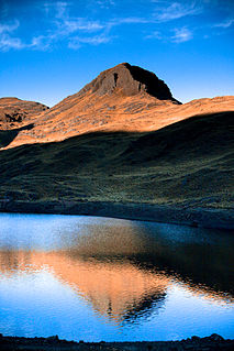
Warawara, often spelled Wara Wara, is a lake in the Tunari National Park in Bolivia. It is located in the Cochabamba Department, Chapare Province, Sacaba Municipality. Warawara lies north east of the city Cochabamba and north of Alalay Lake. The lake is situated 4,105 metres (13,468 ft) high. It is 0.8 km long and 0.5 km at its widest point.

San Ignacio del Sara Place in Santa Cruz Department, Bolivia

San Ignacio del Sara is a town in the Santa Cruz department in the lowlands of the South American Andes state of Bolivia.

Qara Apachita (Chapare)

Q'ara Apachita is a 4,639 m (15,220 ft) mountain in the Bolivian Andes. It is located in the Cochabamba Department, Chapare Province, Villa Tunari Municipality.

Uqi Salli Punta

Uqi Salli Punta is a 4,840-metre-high (15,880 ft) mountain in the Bolivian Andes. It is located in the Cochabamba Department, on the border of the Chapare Province, Villa Tunari Municipality, and the Quillacollo Province, Quillacollo Municipality.

References

  1. World-Gazetteer [ dead link ]
  2. INE – Instituto Nacional de Estadística Bolivia 1992 Archived 2014-01-28 at WebCite
  3. INE – Instituto Nacional de Estadística Bolivia 2001 Archived March 4, 2016, at the Wayback Machine
  4. INE – Instituto Nacional de Estadística Bolivia 2012 Archived March 4, 2016, at the Wayback Machine
  5. "Bolivia- Trinidad" (in Spanish). Centro de Investigaciones Fitosociológicas. Retrieved December 24, 2012.
  6. "Datos Mensuales Precipitation". SENAMHI. Retrieved October 17, 2021.

Coordinates: 16°58′29″S65°25′13″W / 16.97472°S 65.42028°W / -16.97472; -65.42028 .