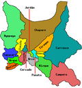
Capinota Municipality | |
---|---|
Municipality | |
Coordinates: 17°46′S66°14′W / 17.767°S 66.233°W | |
Country | Bolivia |
Department | Cochabamba Department |
Province | Capinota Province |
Seat | Capinota |
Population (2001) | |
• Total | 16,945 |
• Ethnicities | Quechuas |
Time zone | UTC-4 (BOT) |
Capinota Municipality is the first municipal section of the Capinota Province in the Cochabamba Department, Bolivia. Its seat is Capinota.
Cochabamba, from Quechua qucha or qhucha, meaning "lake", pampa meaning "plain", is one of the nine departments of Bolivia. It is known to be the "granary" of the country because of its variety of agricultural products from its geographical position. It has an area of 55,631 km2. Its population in the 2012 census was 1,758,143. Its capital is the city of Cochabamba, known as the "City of Eternal Spring" and "The Garden City" because of its spring-like temperatures all year.
Arque is a rural province in Cochabamba Department in the eastern cordillera of the South American state of Bolivia.
Bernardino Bilbao is a province in the Northern parts of the Bolivian department of Potosí. It has its name after Bernardino Bilbao Rioja, Bolivian general and politician.
Capinota is a small town in the Bolivian Department of Cochabamba and capital of the Capinota Province.
Arque River is one of the headwaters of Río Grande and Mamoré River in Bolivia. Arque River has its source in the Kimsa Cruz mountain range on the western slope of the mountain Waylluma at 17°41′0″S66°43′30″W, 50 km northeast of the mining city Oruro and 65 km southwest of Cochabamba.
Santiváñez is a locality in the Cochabamba Department in central Bolivia. It is the capital of Santiváñez Municipality, the second municipal section of the Capinota Province. At the time of census 2001 it had a population of 1,046.
Sicaya or Silaya is a locality in the Cochabamba Department in central Bolivia. It is the seat of the Sicaya Municipality, the third municipal section of the Capinota Province.
Riberalta Municipality is a municipality of the Beni Department, Bolivia.
Arque Municipality is the first municipal section of the Arque Province in the Cochabamba Department, Bolivia. Its seat is Arque. At the time of census 2001 the municipality had 11,806 inhabitants. It has the lowest HDI of Bolivia with 0.311.
Ayopaya Municipality is the first municipal section of the Ayopaya Province in the Cochabamba Department, Bolivia. Its seat is Ayopaya.
Colcapirhua or Qullqapirwa (Quechua) is the fifth municipal section of the Quillacollo Province in the Cochabamba Department, Bolivia. Its seat is Colcapirhua.
Morochata Municipality is the second municipal section of the Ayopaya Province in the Cochabamba Department, Bolivia. Its seat is Morochata.
Santiváñez Municipality is the second municipal section of the Capinota Province in the Cochabamba Department, Bolivia. Its seat is Santiváñez.
Sicaya Municipality is the third municipal section of the Capinota Province in the Cochabamba Department in Bolivia. Its seat is Sicaya.
Tiquipaya Municipality is the third municipal section of the Quillacollo Province in the Cochabamba Department, Bolivia. Its seat is Tiquipaya.
Tacopaya Municipality is the second municipal section of the Arque Province in the Cochabamba Department in Bolivia. Its seat is Tacopaya. At the time of census 2001 the municipality had 11,658 inhabitants.
Tolata Municipality is the third municipal section of the Germán Jordán Province in the Cochabamba Department, Bolivia. Its seat is Tolata.
Vinto Municipality is the fourth municipal section of the Quillacollo Province in the Cochabamba Department, Bolivia. Its seat is Vinto.
El Nancito is a corregimiento in Remedios District, Chiriquí Province, Panama. It has a land area of 35.4 square kilometres (13.7 sq mi) and had a population of 607 as of 2010, giving it a population density of 17.1 inhabitants per square kilometre (44/sq mi). Its population as of 1990 was 786; its population as of 2000 was 519.
Veladero is a corregimiento in Tolé District, Chiriquí Province, Panama. It has a land area of 51.1 square kilometres (19.7 sq mi) and had a population of 1,727 as of 2010, giving it a population density of 33.8 inhabitants per square kilometre (88/sq mi). It was created by Law 10 of March 7, 1997; this measure was complemented by Law 5 of January 19, 1998 and Law 69 of October 28, 1998. Its population as of 2000 was 1,575.
Coordinates: 17°48′00″S66°14′00″W / 17.8°S 66.2333°W
This Cochabamba Department location article is a stub. You can help Wikipedia by expanding it. |