Mizque Province

Last updated
Mizque
Province
Bolivia Cochabamba Mizque.png
Location of the Mizque Province within Bolivia
Bolivia department of cochabamba.png
Provinces of the Cochabamba Department
Coordinates: 18°00′00″S66°00′0″W / 18.00000°S 66.00000°W / -18.00000; -66.00000
Country Flag of Bolivia.svg Bolivia
Department Cochabamba
Capital Mizque
Area
  Total1,050 sq mi (2,730 km2)
Population
 (2001)
  Total36,181
  Density34/sq mi (13.3/km2)
  Ethnicities
Quechua
Time zone UTC-4 (BOT)

Mizque (from Quechua: misk'i, meaning "sweet") is a province in the Cochabamba Department, Bolivia. Its capital is Mizque.

Contents

The province, in 1992, had a population of 27,959 inhabitants, mostly indigenous citizens of Quechuan descent. In 2001, the population increased to 36,181 inhabitants and it was estimated at 41,062 in 2005. [1]

Geography

Mizque Province is home to a great diversity of ecoregions because it contains a wide variety of topographic features with heights ranging between 2,000 and 3,600 m. The province belongs to the Julpe-Mizque basin with an area of 3,845 km2.

The main rivers are:

Although there is a large amount of superficial and sub-superficial water within the province, the zone is suffering from drought due to the lack of irrigation systems.

Some of the highest mountains of the province are listed below: [2] [3] [4] [5]

Climate

The climate is dry. There are a few irregular rainfalls and long periods of drought. The medium annual temperature varies between 16 and 18 °C. During the rainy season ("summer"), corresponding to the months from December to March, the province receives 87% of the annual precipitation, in December and January alone 57%, often occurring as hailstorms. During the dry season ("winter") the temperature goes down radically and snowfalls occur. The annual precipitation is between 300 and 700 mm, reaching 507 mm annually on an average.

Flora

The semiarid and arid regions are covered with plants which are tolerant towards dry conditions. 75% of the total area of Mizque Province is cultivated.

Fauna

Red-fronted macaw (Ara rubrogenys) Ara rubrogenys -Jurong BirdPark-8.jpg
Red-fronted macaw (Ara rubrogenys)

The red-fronted macaws (Ara rubrogenys), endemic to a small mountainous area of Bolivia, can be observed in Mizque. This species is considered to be endangered due to intense agriculture activity which has reduced its habitat. The problem is that the peasants of some zones look upon them as a plague because they raid the maize in the fields. There is a chance that they might be regarded as one of the tourist attractions of the region. [6]

Subdivision

The province is divided into three municipalities which are further subdivided into ten cantons.

SectionMunicipalityInhabitants [7] SeatInhabitants [8] Cantons
1st Mizque 26,659 Mizque 2.677Cauta, Mizque, Molinero, Taboada, Tin Tin, Vicho Vicho
2nd Vila Vila 4,591 Vila Vila 426Siquimira, Vila Vila
3rd Alalay 4.931 Alalay 638Alalay, Ayapampa

The people

The majority of the population of the Mizque Province lives in the rural area in communities far apart from each other. The lack of good roads makes trade and providing services difficult. The land in some areas is quite dry and not appropriate for farming. That may be some of the reasons why the Human Development Index in the municipalities of Mizque is among the lowest in Bolivia (0.365, 0.400 and 0.460), placing them in the positions 284 (Mizque), 305 (Vila Vila) and 298 (Alalay) out of 314 municipalities. [9]

The conditions of life are especially critical in the puna and remote communities. The level of income of a peasant family in the high zones or in the dryland is estimated at 200 - 250 US-$ per year.

Some data: [10]

Mizque Province
MunicipalityMizqueVila VilaAlalay
Nacional ranking (out of 314)284305298
Human Development Index (2001)0.4300.3650.400
Life Expectancy Index 0.4530.3940.540
Education Index 0.5090.4540.440
Life expectancy (years)52.248.757.4
Literacy of adults (% of 15 years old and more)61.455.966.2
Average years of schooling 3.12.12.8
Population census 200126,6594,5914,931
Percentage of rural population90.0%100.0%100.0%

There are 182 rural communities within the territory of the province situated in heights between 2,000 m in the template valleys and 3,600 m in the puna.

Language

The predominant language is Quechua, spoken by 32,212 inhabitants and about 11,482 inhabitants are bilingual. They can speak Spanish as well. The following table shows the number of those belonging to the recognized group of speakers. [11]

LanguageMizque MunicipalityVila Vila MunicipalityAlalay Municipality
Quechua 24.2124.2294.529
Aymara 1721112
Guaraní 859
Another native1021
Spanish 8.3787891.002
Foreign4164
Only native16.4993.4933.549
Native and Spanish7.753742987
Only Spanish6264715

Economy

The economic activity is concentrated on agriculture and animal husbandry and to a minor extent on mining and crafts. The most important sectors in agriculture are the cultivation of potatoes, maize, wheat, peanuts, barley and onions.

Festivals and Fairs

Related Research Articles

Arani Province Province in Cochabamba Department, Bolivia

Arani is a province in Cochabamba Department, Bolivia. Its capital is Arani, situated about 53 km from Cochabamba. Arani is known for its bread and its artisan wickerwork.

Arque Province Province in Cochabamba Department, Bolivia

Arque is a rural province in Cochabamba Department in the eastern cordillera of the South American state of Bolivia.

Carrasco Province Province in Cochabamba Department, Bolivia

Carrasco is a province in the Cochabamba Department in central Bolivia. Its capital is Totora.

Quillacollo Province Province in Cochabamba Department, Bolivia

Quillacollo is a province in the Cochabamba Department, Bolivia. It is known for its festival in August where people from all over Bolivia come and pay homage to the Virgin of Urqupiña. Quillacollo is said to be one of the fastest growing cities in Bolivia.

Tomás Frías Province Province in Potosí Department, Bolivia

Tomás Frías is a province in the northern parts of the Bolivian Potosí Department. Its capital is Potosí which is also the capital of the department. The province is named after the former president Tomás Frías Ametller.

Antonio Quijarro Province Province in Potosí Department, Bolivia

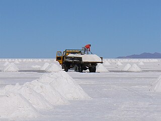
Antonio Quijarro is a province in the central parts of the Bolivian Potosí Department situated at the Salar de Uyuni. Its seat is Uyuni.

Nor Chichas Province Province in Potosí Department, Bolivia

Nor Chichas is a province in the Eastern parts of the Bolivian Potosí Department. Its seat is Cotagaita.

Oropeza Province Province in Chuquisaca Department, Bolivia

Oropeza is a province in the Chuquisaca Department, Bolivia. Its seat is Sucre which is also the constitutional capital of Bolivia and the capital of the Chuquisaca Department.

Tomina Province Province in Chuquisaca Department, Bolivia

Tomina is a province in the Chuquisaca Department in Bolivia. Its seat is Padilla.

Chayanta Province Province in Potosí Department, Bolivia

Chayanta is a province in the northern parts of the Bolivian Potosí Department. Its capital is Colquechaca.

Vacas Municipality Municipality in Cochabamba Department, Bolivia

Vacas Municipality is the second municipal section of the Arani Province in the Cochabamba Department in central Bolivia. Its capital is Vacas known as the "Land of the potato". During the Inca Empire Vacas served as a tampu along the Inca road system that led to Inkallaqta and Pocona.

Pocona Municipality Municipality in Cochabamba Department, Bolivia

Pocona Municipality is the third municipal section of the Carrasco Province in the Cochabamba Department in Bolivia. Its seat is Pocona. At the time of census 2001 the municipality had 13,488 inhabitants.

Quillacollo Municipality Municipality in Cochabamba Department, Bolivia

Quillacollo Municipality is the first municipal section of the Quillacollo Province in the Cochabamba Department, Bolivia. Its capital is Quillacollo. At the time of census 2001 the municipality had 104,206 inhabitants.

Alalay Municipality Municipality in Cochabamba Department, Bolivia

Alalay Municipality is the third municipal section of the Mizque Province in the Cochabamba Department, Bolivia. Its seat is Alalay.

Mizque Municipality Municipality in Cochabamba Department, Bolivia

Mizque Municipality is the first municipal section of the Mizque Province in the Cochabamba Department, Bolivia. Its seat is Mizque.

Vila Vila Municipality Municipality in Cochabamba Department, Bolivia

Vila Vila or Wila Wila (Aymara) is the second municipal section of the Mizque Province in the Cochabamba Department, Bolivia. Its seat is Vila Vila.

Potosí Municipality Municipality in Potosí Department, Bolivia

Potosí Municipality is the capital municipality of the Tomás Frías Province in the Potosí Department in Bolivia. Its seat is Potosí which is the capital of the department as well.

Ravelo Municipality Municipality in Potosí Department, Bolivia

Ravelo Municipality is the second municipal section of the Chayanta Province in the Potosí Department in Bolivia. Its seat is Ravelo.

Chullpa Qasa

Chullpa Q'asa is a 2,826-metre-high (9,272 ft) mountain in the Bolivian Andes. It is located in the Cochabamba Department, Mizque Province, Vila Vila Municipality. Chullpa Q'asa lies southwest of Jatun Urqu.

Puka Qallpa Mountain in Bolivia

Puka Qallpa is a 3,886-metre-high (12,749 ft) mountain in the Bolivian Andes. It is located in the Cochabamba Department, Mizque Province, Alalay Municipality. It lies in the northwest of Kachi Q'asa and northeast of Inka Pirqa. The Puka Urqu Mayu flows along its western slope. Its waters flow to the Jatun Mayu in the south.

References

  1. www.ine.gov.bo Archived 2007-08-25 at the Wayback Machine
  2. Bolivia 1:100,000 Punata 3735
  3. Bolivia 1:100,000 Mizque 3835
  4. "Vila Vila". INE, Bolivia. Archived from the original on April 13, 2016. Retrieved April 4, 2016.
  5. "Mizque". INE, Bolivia. Archived from the original on February 3, 2016. Retrieved April 9, 2016.
  6. www.pieb.com.bo (Spanish)
  7. "www.enlared.org.bo". Archived from the original on 2008-08-28. Retrieved 2009-01-24.
  8. world-gazetteer.com [ dead link ]
  9. cdteca.enlared.org.bo Archived 2009-01-19 at the Wayback Machine (Spanish)
  10. Informe sobre Desarollo Humano Archived 2009-01-19 at the Wayback Machine (Spanish)
  11. obd.descentralizacion.gov.bo Archived 2009-02-18 at the Wayback Machine (Spanish)

Coordinates: 18°00′S66°00′W / 18.000°S 66.000°W / -18.000; -66.000