
Abel Iturralde is one of the twenty provinces of the Bolivian La Paz Department. It is situated in its northern part. Its name honors Abel Iturralde Palacios, a Bolivian politician. Madidi National Park is partially in this province.

Bautista Saavedra is one of the twenty provinces of the Bolivian La Paz Department situated in the northwestern parts of the department. It was created on November 17, 1948 in honor of Bautista Saavedra Mallea (1870-1939) who was Bolivia's president from 1920 to 1925. The capital of the province is Charazani.
Villa Tunari or Tunari is a location in the department of Cochabamba, Bolivia. It is the seat of the Villa Tunari Municipality, the third municipal section of the Chapare Province. According to the census 2012 the population was 3,213 in the town which is an increment from 2,510 registered during the 2001 census.

San Borja is a city in the Beni Department in northern Bolivia, It is the most populous city in the province of General José Ballivián.
Federico Román is one of the five provinces of the Bolivian department of Pando and is situated in the department's northeastern parts. Its name honours General Federico Román.

Manuripi is one of the five provinces of Pando Department in Bolivia and is situated in the northwest of the department. Its name is derived from the Manuripi River, which passes through the province from west to east.

Nicolás Suárez is one of the five provinces of the Bolivian Pando department and is situated in the department's northwestern parts. Its name honors Nicolás Suárez Callaú (1861-1940) who owned major parts of today's Pando and Beni Departments in the times of the caoutchouc-boom.

Ichilo is one of the fifteen provinces of the Bolivian Santa Cruz Department and is situated in the department's north-western parts. The province was founded by a decree of 8 April 1926 and is named after Río Ichilo which is forming the province border in the West.

Santa Ana de Velasco is a small town in the Santa Cruz Department, Bolivia.
Entre Ríos is a small town in the Cochabamba Department of the South American Republic of Bolivia.

Quillacollo Municipality is the first municipal section of the Quillacollo Province in the Cochabamba Department, Bolivia. Its capital is Quillacollo. At the time of census 2001 the municipality had 104,206 inhabitants.
Sipe Sipe Municipality is the second municipal section of the Quillacollo Province in the Cochabamba Department, Bolivia. Its seat is Sipe Sipe. At the time of census 2001 the municipality had 31,337 inhabitants.

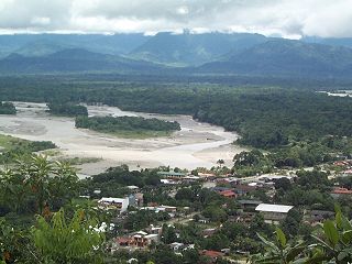
Rurrenabaque is a municipality in the José Ballivián Province in the Beni Department of Bolivia. The seat of the municipality is the town of Rurrenabaque. At the 2001 census the municipality had 14,000 inhabitants, of which 8,000 lived in the town of Rurrenabaque.
Vinto is a town in the Cochabamba Department in central Bolivia. It is the seat of the Vinto Municipality, the fourth municipal section of the Quillacollo Province.
San Ramón is a small town in the Beni Department in Bolivia.

Cotoca is a canton and Municipality of Andrés Ibáñez Province in Santa Cruz Department, Bolivia. The municipality consists of two cantons – Cotoca itself and Puerto Pailas. In 2010 it had an estimated population of 23,951 for the canton and 56,451 for the municipality.
Entre Ríos Municipality is the sixth municipal section of the Carrasco Province in the Cochabamba Department in central Bolivia. Its seat Entre Ríos had 3,796 inhabitants at the time of census 2001.

Azurduy Municipality is the first municipal section of Azurduy Province in the Chuquisaca Department of Bolivia. Its seat is Villa Azurduy. In 2012 the population was 10,594 persons. The municipality is very poor; in 2010 93% were below the poverty line, and 75% were in extreme poverty. In 2001 there were seven automobiles in the municipality.
Mineros is a city of Bolivia, capital of the Mineros Municipality of the Santa Cruz Department, 83 km north of the city of Santa Cruz de la Sierra. Due to the policy of the 1960s that forced the indigenous people of the Altiplano to immigrate, 23.3% of the population knows how to speak Quechua.

The Kanata Metropolitan Area is the Metropolitan Region of the Department of Cochabamba. The region is made up of the municipalities of Cochabamba, Colcapirhua, Quillacollo, Sacaba, Sipe Sipe, Tiquipaya and Vinto, adding a total of seven con-urbanized municipalities. It limits to the north with the municipalities of Cocapata and Villa Tunari, to the west with the municipalities of Morochata and Tapacarí to the south with the municipalities of Arbieto, Arque, Capinota, San Benito, Santiváñez, Sicaya and Tolata to the east with the municipalities of Colomi and Tiraque. being the penultimate included as part of this region in its plans for future development, the municipalities of the metropolitan area are arranged in an east–west direction and vice versa, structured by the most important road in the country, Route 4. With a total area of 2,611 km2 where approximately 1.5 million inhabitants coexist.

