Apolo is a location in the Franz Tamayo Province in the La Paz Department, Bolivia, South America, with a population of 2,123 in the year 2001. It is the seat of the Apolo Municipality.
Inquisivi is the capital of the Inquisivi Province in the La Paz Department, Bolivia. It was officially named on November 2, 1844. Residents of Inquisivi are called Inquisivenos.

Achacachi is a town on the Altiplano plateau in the South American Andes in the La Paz Department in Bolivia. It is the capital of the Omasuyos Province.

Camiri is a city in Bolivia, Santa Cruz Department, Cordillera Province. It is the seat of the Camiri Municipality. The town has an estimated population of 65,897 inhabitants, also known as "Camireños." Camiri is on the banks of the Parapeti River in a small valley surrounded by rolling hills on the east, north, and south, and by the Aguarague mountain range on the west.

Guayaramerín is a city within the Bolivian Beni Department. It is the capital of the Guayaramerín Municipality in the Vaca Díez Province. Guayaramerín is located on the west side of the Mamoré River, facing the Brazilian city of Guajará-Mirim. It is a port in which there is a permanent port of the Bolivian Navy. Guayaramerín Airport is south of the city, and served by Ecojet.
Uriondo is a town in the Bolivian Tarija Department.
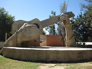
Aiquile is a town in the Cochabamba Department, Bolivia. It is the capital of the Narciso Campero Province and Aiquile Municipality. Most of its population is Quechua, and its residents are reputed to be the best charango makers in the country.
Anzaldo is a location in the Cochabamba Department in central Bolivia. It is the seat of the Anzaldo Municipality, the second municipal section of the Esteban Arce Province.
Batallas is a location in the La Paz Department in Bolivia. It is the seat of the Batallas Municipality, one of the four municipalities of the Los Andes Province.
Caquiaviri is a location in the La Paz Department in Bolivia. It is the seat of the Caquiaviri Municipality, the second municipal section of the Pacajes Province.
Charaña is a high elevation town in the altiplano of the La Paz Department in Bolivia. It is the seat of the Charaña Municipality, the fifth municipal section of the Pacajes Province.
Coripata is a town in the La Paz Department, Bolivia.

Irupana is a location in the La Paz Department in Bolivia. It is the seat of the Irupana Municipality, the second municipal section of the Sud Yungas Province.
Santiago de Andamarca is a small location in Bolivia in the Oruro Department, Sud Carangas Province. It is the seat of the Santiago de Andamarca Municipality. In 2010 the village had an estimated population of 374.
Challapata is the capital of the Eduardo Abaroa Province as well as of the Challapata Municipality in the Oruro Department in Bolivia. It lies at an altitude of 3,738 m above sea level on the edge of the 250-acre (1.0 km2) flood plain of the river on the east bank of the Tacagua Poopó Lake. Challapata is located half way of the road and railway connection from Oruro to Potosí, about 130 kilometers from both cities. Directly southeast of the city rises the Cerro Azanaques, with 5102 m the highest peak in the Azanaques Mountain Range (Cordillera de Azanaques).

Culpina is a small town in Bolivia. In 2010 it had an estimated population of 2,747.

Curahuara de Carangas is a small town in the Bolivian Oruro Department. It is the seat of the Sajama Province. In 2009 it had an estimated population of 1,581.
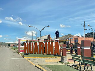
Huarina is a location in the La Paz Department in Bolivia. It is the seat of the Huarina Municipality, one of the four municipalities of the Omasuyos Province. President of Peru Andrés de Santa Cruz was born here.
Colcha K is a village serving as the capital of Nor Lípez Province, in the Potosí Department of Bolivia. It is also the capital of the Colcha "K" Canton and Colcha "K" Municipality.
Betanzos is a town located in the Potosí Department of Bolivia. It is the capital of the Betanzos Canton, Betanzos Municipality and Cornelio Saavedra Province.


