Cochabamba, from Quechua qucha or qhucha, meaning "lake", pampa meaning "plain", is one of the nine departments of Bolivia. It is known to be the "granary" of the country because of its variety of agricultural products from its geographical position. It has an area of 55,631 km2. Its population in the 2012 census was 1,758,143. Its capital is the city of Cochabamba, known as the "City of Eternal Spring" and "The Garden City" because of its spring-like temperatures all year.
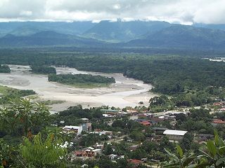
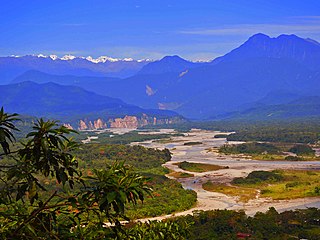
Chapare (Spanish:[tʃaˈpaɾe], also called The Chapare, is a rural province in the northern region of Cochabamba Department in central Bolivia. Most of the territory consists of valley rainforests that surround the area's main waterway, the Chapare River, which is also a tributary of the Amazon River. The provincial capital is Sacaba, 11 km east of Cochabamba. Its principal town is Villa Tunari, a popular tourist destination.
Villa Tunari or Tunari is a location in the department of Cochabamba, Bolivia. It is the seat of the Villa Tunari Municipality, the third municipal section of the Chapare Province. According to the census 2012 the population was 3,213 in the town which is an increment from 2,510 registered during the 2001 census.

Lauca National Park is located in Chile's far north, in the Andean range. It encompasses an area of 1,379 km2 of altiplano and mountains, the latter consisting mainly of enormous volcanoes. Las Vicuñas National Reserve is its neighbour to the south. Both protected areas, along with Salar de Surire Natural Monument, form Lauca Biosphere Reserve. The park borders Sajama National Park in Bolivia.
Amboró National Park in central Bolivia is a nature reserve with over 912 species of birds, over 177 mammalian species including puma, ocelot, and the rare spectacled bear. Covering an area of 4,425 km², it is protected from human settlements, hunting, mining and deforestation, though problems with all these still exist within the park. The Carrasco National Park is placed adjacent to Amboró, and together the two form a larger conservation unit.
The Ulla Ulla National Reserve - which today is part of Apolobamba Integrated Management Natural Area - was created in 1972 with an extension of 240,000 ha, a biosphere reserve located in the Franz Tamayo Province, in the Department of La Paz in western Bolivia.
Rhinella amboroensis is a species of toad in the family Bufonidae that is endemic to the region of its type locality in the Carrasco Province of Bolivia and the adjacent Santa Cruz Department. Its common name is Cochabamba toad. It may exist in the Carrasco National Park and/or Amboró National Park, depending on its exact range.
Microkayla adenopleura is a species of frog in the family Strabomantidae. It is endemic to Bolivia and only known from near its type locality in the Carrasco National Park, Cochabamba Department, at elevations of 3,250–3,400 m (10,660–11,150 ft) asl. It is a common species living in low, humid montane forest typical to the transition between Yungas forest and páramo. Outside the national park, if present, it would be threatened by habitat loss.
Microkayla iatamasi is a species of frog in the family Strabomantidae.

The Llanos de Moxos, also known as the Beni savanna or Moxos plains, is a tropical savanna ecoregion of the Beni Department of northern Bolivia.

The following outline is provided as an overview of and topical guide to Bolivia:

Totora, Tutura or T'utura is a town in the Carrasco Province of the Cochabamba Department in Bolivia. It is the capital and most-populous place of the Totora Municipality. As of the 2012 census, the population is 1,925. The first settlers were Inca Indians. Totora was officially settled in 1876, and declared a town by the Government of Bolivia in 1894.

Isiboro Sécure National Park and Indigenous Territory is a protected area and Native Community Land in Bolivia situated between the north of the Cochabamba Department and the south of the Beni Department. It protects part of the Bolivian Yungas ecoregion. The indigenous people living within the park belong to the Tsimané, Yuracaré, and Mojeño-Trinitario peoples. The southern portion of the park has been colonized by agricultural settlers, primarily coca farmers, since the 1970s. The Bolivian government estimates that 10% of the park has been deforested by their presence.

Cordillera de Sama Biological Reserve is a protected area in Bolivia located in the Tarija Department, in the Cercado Province, Eustaquio Méndez Province, and José María Avilés Province. It protects part of the Central Andean puna and Bolivian montane dry forests ecoregions.
Tariquía Flora and Fauna National Reserve is a protected area in the Tarija Department, Bolivia, situated in the Aniceto Arce Province, Burnet O'Connor Province, Gran Chaco Province and José María Avilés Province. It protects part of the Central Andean puna, Southern Andean Yungas, and Bolivian montane dry forests ecoregions.
Pocona is a location in the Cochabamba Department in central Bolivia. It is the seat of the Pocona Municipality, the third municipal section of the Carrasco Province. At the time of census 2001 it had a population of 244.
Conda Canton is one of the cantons of the Pocona Municipality, the third municipal section of the Carrasco Province in the Cochabamba Department in central Bolivia. Its seat is Conda.

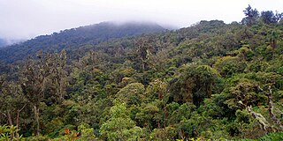
The Bolivian Yungas is a tropical and subtropical moist broadleaf forest ecoregion in the Yungas of central Bolivia.

Coca has been cultivated in medium-altitude parts of the Bolivian Andes since at least the Inca era, primarily in the Yungas north and east of La Paz. Cultivation expanded substantially in the 1980s into the Chapare region of Cochabamba and some production flowed into the international cocaine market. The US-backed efforts to criminalize and eradicate coca as part of the War on Drugs were met by the cocalero movement's growing capacity to organize. Violence between drug police and the Bolivian armed forces on one side and the movement on the other occurred episodically between 1987 and 2003. The cocaleros became an increasingly important political force during this period, co-founding the Movement for Socialism – Political Instrument for the Sovereignty of the Peoples party. Coca growers from both the Yungas and the Chapare have advocated for policies of "social control" over coca growing, maintaining a pre-set maximum area of cultivation as an alternative to drug war policies. In 2005, cocalero union leader Evo Morales was elected president of Bolivia. Morales has pursued a combined policy of legalizing coca production in the Chapare and Yungas and eradication of the crop elsewhere.

