Kaa-Iya is a term from Guarani mythology which means "mountain owners", or a place where riches are found, in the sense of abundance of natural resources and the relationship between man and nature.
Altitude: between 100 and 839 meters above sea level.
Rainfall: 1,400 to 400mm annually.
Hydrology: The principal river is the Parapetí, among many others.
Coordinates: Latitude 17º42’30’’ - 20º02’30" S, Longitude 60º03’30’’ – 62º31’30’’ W
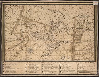
Boundaries of the park in southeastern Bolivia.
Characteristics of the area
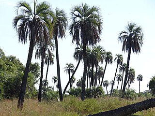
It is principally known for containing the largest tropical wooded area in the world. It also contains an incredible range of animal species, most notably the last remaining large felidae and more than 100 other distinct species of mammal.
Kaa-Iya del Gran Chaco is linked with Otuquis National Park and newly created Ñembi Guasu conservation area, covering about 60,000km2 of Gran-Chaco forest.[1]
The fauna present in the area is representative of the Chaqueña plains region, with 350 registered species, 89 species of snakes, 301 species of birds, 65 species of small mammals and 59 species of large mammals. Foremost among these are the Chacoan peccary, known locally as tagua or quilimero pig, a common species in Chaco, armadillos (Tolypeutes matacus and Chlamyphorus retusus), common in the region, the Chacoan mara and Conover's tuco-tuco. The jaguar, puma, ocelot and maned wolf can also be found.
Kaa Iya National Park is internationally famous for its big cat population, especially the jaguar. It is considered[by whom?] as one of the best places in the world for jaguar viewing opportunities. A camera trap study by WCS estimated that there are over 1000 jaguars living within the park which makes it one of the most important areas for the survival of these big cats. Tapirs, pumas, ocelots and more are seen frequently inside the park.
Local population
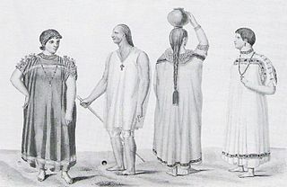
The pattern of human occupation in the area is made up of the Guaranís and Chiquitanos villages as well as farmers. Human presence is only in the outlying areas although it is moving inwards in respect to the use of the area's resources. There is a greater concentration of people towards the west (Isozo), Chiquitano settlements in the north and some scattered communities in other areas. In any case, it can be confirmed that the interior of the area is free of human occupation.
The greatest concentration of people is found towards the west (Bañados de Izoso), in the area's power base, where there are more than twenty Guaraní communities, including Guarirenda, Rincón, Huirapendi, Guirayasa, Coropo, Cacharí, Aguraigua, Guirapendio, Isiporenda, and Yapiroa. The largest Chiquitana community is San Pablo, located in the north.
There are groups of mostly Izoceños and Ayoreode origin, including uncontacted groups of Ayoreo nomads.
The ruins of San Ignacio de Zamucos, a Jesuit mission that was active from 1724 to 1745, are located in the southeastern end of the Kaa-Iya del Gran Chaco National Park.
Administration
The development of the national park is being carried out under shared administration, under an agreement with the Upper and Lower Izozog Authority (Capitanía del Alto y Bajo Izozog), an indigenous Izoceño-Guaraní organisation, signed on 24 November 1995.
The development committee is composed of representatives from the municipalities of Charagua, Pailón, San José de Chuiquitos, and the sub-mayoralty of Isoso, as well as the founding organisations of TURUBO, CABI, CICHIPA (Indigenous Office for Chiquitano Communities of Pailón), Santa Teresita (Ayorea Community), CIMCI, and representatives of the government, SERNAP and the Departmental Prefecture.
Relevant aspects
The park makes up the only area set aside to protect the extensive remaining areas of the South American Chaco, including most of the ecosystems belonging to the region.
This park, despite its low prominence and the apparent monotony of its countryside, is of great interest due to the enormous richness of its wildlife for the development of eco- and adventure-tourism.
The presence of representatives of the indigenous Izoceño, Chiquitano and Ayorea populations increases the importance of the area; among other cultural expressions, they produced very stylised craftwork.
There are historic sites in the power base of the region, e.g. the Missions of San José de Chiquitos and Santa Cruz la Vieja.
The population mostly consists of the Izoceño, Chiquitano and Ayoreode ethnicities, including a group of Ayoreode nomads. There are other populations recently migrated from other regions of Santa Cruz (ranch owners, farm workers, rural manual workers) who mostly work in cattle ranching.
Potential
Given its double categorisation as National Park and Integrated Management Natural Area, the Area presents enormous possibilities for developing wildlife management programs of regional applicability.
The region undoubtedly constitutes an important natural reservoir of genetic diversity, both animal and human (indigenous Guaraní cultures). Furthermore, due to its natural and cultural value, tourist operations could be developed in the Area.
The biological diversity of the Protected Area is due to variability in climate and soil conditions, as well as the lack of availability of water, which influence the unusual flora and fauna of the region.
Threats
The most serious threats to the park come principally from hydrocarbon-related activities; seismic prospecting in the Bañados, drilling for petroleum in Ustarez and the Bolivia-Brazil gas pipelines, followed by the expansion of agricultural and cattle-ranching landuse; illegal commercial hunting and the diversion of the river Parapeto for agricultural purposes.
Power base
The area's most important settlements are Camiri, Charagua, Boyuibe and Cabezas in Cordillera Province, and San José in Chiquitos Province.
Accessibility
Access to the area is difficult. In the humid season, the Area's roads are unusable. Except for the Santa Cruz-Bajo Izoso-Camiri road which borders the Area and partially enters the communities of Bajo Izoso, there are no other stable roads. In many zones entrance is via cattle paths. From San José de Chiquitos there is a bridlepath which joins Fortín Ravelo and Suárez Arana, forming the most stable path in the extreme east of the Area.
Related Research Articles
Chiquitania is a region of tropical savannas in the Santa Cruz Department in eastern Bolivia.
Santa Cruz is the largest of the nine constituent departments of Bolivia, occupying about one-third (33.74%) of the country's territory. With an area of 370,621 km2 (143,098 sq mi), it is slightly smaller than Japan or the US state of Montana. It is located in the eastern part of the country, sharing borders in the north and east with Brazil and with Paraguay in the south.
The Gran Chaco or Dry Chaco is a sparsely populated, hot and semiarid lowland tropical dry broadleaf forest natural region of the Río de la Plata basin, divided among eastern Bolivia, western Paraguay, northern Argentina, and a portion of the Brazilian states of Mato Grosso and Mato Grosso do Sul, where it is connected with the Pantanal region. This land is sometimes called the Chaco Plain.
Cordillera is a province in the Santa Cruz Department, Bolivia. Its capital is Lagunillas.
The Chaco National Park is a national park of Argentina, located in the province of Chaco. It has an area of 150 km2. It was created in 1954 in order to protect a sample of the Eastern Chaco, composed mainly of warm lowlands, with an annual summer rainfall between 750 and 1,300 mm.
The Confederation of Indigenous Peoples of Bolivia is a national representative organization of the Bolivian indigenous movement. It was founded in October 1982 in Santa Cruz de la Sierra as the Confederation of Indigenous Peoples of the Bolivian East, with the participation of representatives of four indigenous peoples of the Bolivian East: Guarani-Izoceños, Chiquitanos, Ayoreos and Guarayos.
Chiquitano is an indigenous language isolate spoken in the central region of Santa Cruz Department of eastern Bolivia and the state of Mato Grosso in Brazil.
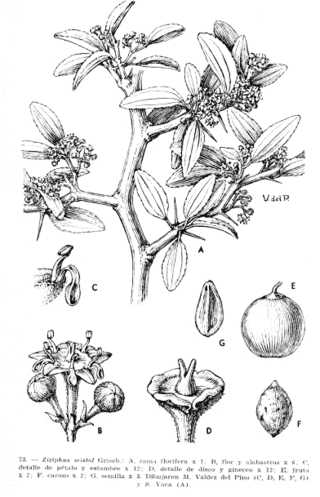
Sarcomphalus mistol or mistol is a species of spiniferous shrub or tree of the family Rhamnaceae. It is native to Peru, Bolivia, Paraguay, and northern Argentina in South America, and very abundant in parts of the Gran Chaco of northern Argentina and Paraguay. The word "mistol" derives from colonial era Spanish, from the word "mixture" (mezcla) since it was believed that mistol was a hybrid between species of genus Schinopsis because of the likely color of its wood to Spaniard colonists' perception.
Mburucuyá National Park is a national park in Argentina. It is located in the north west of the Corrientes Province around 150 km (93 mi) from the city of Corrientes and covers an area of 176 square kilometres (68 sq mi) of the Iberá Wetlands.
The Gran Chaco is a plain of about 1.000.000 km2. It covers parts of Bolivia, Paraguay, Brazil and Argentina.
The Jesuit Missions of Chiquitos are located in the Santa Cruz department in eastern Bolivia. Six of these former missions collectively were designated as a UNESCO World Heritage Site in 1990. Distinguished by a unique fusion of European and Amerindian cultural influences, the missions were founded as reductions or reducciones de indios by Jesuits in the 17th and 18th centuries to convert local tribes to Christianity.
Chiquitos Province is one of the fifteen provinces of the Bolivian Santa Cruz Department, situated in the center of the department. Its capital is San José de Chiquitos.
San Matías Integrated Management Natural Area is a protected area in Bolivia located in the Santa Cruz Department.
The Parapetí River is a river in Bolivia that has its source on the eastern side the Andes, flows through the Gran Chaco of Bolivia and ends in the marshes of the Bañados de Izozog depression. The drainage basin is 25,300 km2, and with the inclusion of the Bañados of Izozog is 61,903 km2.
The Chiquitano or Chiquitos are an indigenous people of Bolivia, with a small number also living in Brazil. The Chiquitano primarily live in the Chiquitania tropical savanna of Santa Cruz Department, Bolivia, with a small number also living in Beni Department and in Mato Grosso, Brazil. In the 2012 census, self-identified Chiquitanos made up 1.45% of the total Bolivian population or 145,653 people, the largest number of any lowland ethnic group. A relatively small proportion of Bolivian Chiquitanos speak the Chiquitano language. Many reported to the census that they neither speak the language nor learned it as children. The Chiquitano ethnicity emerged among socially and linguistically diverse populations required to speak a common language by the Jesuit Missions of Chiquitos.
Indigenous peoples in Bolivia, or Native Bolivians, are Bolivian people who are of indigenous ancestry. They constitute anywhere from 20 to 60% of Bolivia's population of 11,306,341, depending on different estimates, and depending notably on the choice "Mestizo" being available as an answer in a given census, in which case the majority of the population identify as mestizo, and they belong to 36 recognized ethnic groups. Aymara and Quechua are the largest groups. The geography of Bolivia includes the Andes, the Gran Chaco, and the Amazon Rainforest.
San Ignacio de Zamucos or San Ignacio was a Jesuit mission in Santa Cruz Department, Bolivia that was founded in 1724 and abandoned in 1745. The inhabitants of the mission were the Zamucoan-speaking Ayoreo.
Astrothelium pyrenuliforme is a species of corticolous (bark-dwelling) lichen in the family Trypetheliaceae. Found in Bolivia, it was formally described as a new species in 2016 by lichenologists Adam Flakus and André Aptroot. The type specimen was collected by the first author from Kaa-Iya del Gran Chaco National Park and Integrated Management Natural Area at an altitude of 340 m (1,120 ft), where it was found growing on bark in a Chiquitano dry forest. It is only known to occur at the type locality. The species epithet pyrenuliforme refers to its resemblance to genus Pyrenula.
Polymeridium xanthoexcentricum is a species of corticolous (bark-dwelling), crustose lichen in the family Trypetheliaceae. It is found in southwestern Bolivia.
This page is based on this Wikipedia article Text is available under the CC BY-SA 4.0 license; additional terms may apply. Images, videos and audio are available under their respective licenses.