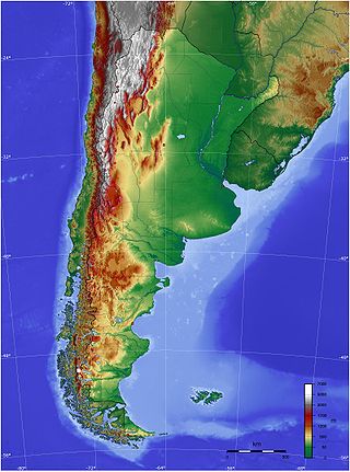
The geography of Argentina is heavily diverse, consisting of the Andes Mountains, pampas, and various rivers and lakes. Bordered by the Andes in the west and the South Atlantic Ocean to the east, its neighbouring countries are Chile to the west, Bolivia and Paraguay to the north, and Brazil and Uruguay to the northeast.

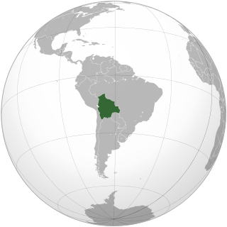
The geography of Bolivia includes the Eastern Andes Mountain Range which bisects Bolivia roughly from north to south. To the east of that mountain chain are lowland plains of the Amazon Basin, and to the west is the Altiplano which is a highland plateau where Lake Titicaca is located. Bolivia's geography has features similar to those of Peru which abuts Bolivia's northwest border; like Bolivia, Peru is bisected from north to south by the Eastern Andes Mountains, and these two countries share Lake Titicaca which is the highest navigable lake on Earth. Unlike Peru, however, Bolivia is one of the two landlocked countries in South America, the other being Paraguay, which is located along Bolivia's southeast border.

Tarija is a department in Bolivia. It is located in south-eastern Bolivia bordering with Argentina to the south and Paraguay to the east. According to the 2024 census, it has a population of 534,348 inhabitants. It has an area of 37,623 km2 (14,526 sq mi). The city of Tarija is the capital of the department.

Chuquisaca ; Guarani: Chuquisaca; Quechua: Chuqichaka; Aymara: Chuqisaka) is a department of Bolivia located in the center south. It borders on the departments of Cochabamba, Tarija, Potosí, and Santa Cruz. The departmental capital is Sucre, which is also the constitutional capital of Bolivia.

Santa Cruz is the largest of the nine constituent departments of Bolivia, occupying about one-third (33.74%) of the country's territory. With an area of 370,621 km2 (143,098 sq mi), it is slightly smaller than Japan or the US state of Montana. It is located in the eastern part of the country, sharing borders in the north and east with Brazil and with Paraguay in the south.

Pilcomayo is a river in central South America. At 1,100 kilometres (680 mi) long, it is the longest western tributary of the Paraguay River. Its drainage basin is 270,000 square kilometres (100,000 sq mi) in area, and its mean discharge is 200 cubic metres per second (7,100 cu ft/s).

The Bermejo River is a river in South America that flows from Bolivia to the Paraguay River in Argentina. The river is generally called Bermejo in spite of its different names along its way, but it also has its own Native American names; in Wichí it is called Teuco, and in Guaraní it is called Ypitá. In the plains of Argentina's Gran Chaco the Bermejo forms wetlands and splits into two branches. The southern branch is the bed of the old Bermejo River, now an intermittent stream called Río Bermejito. The northern branch is now the main stem of the Bermejo and is called the Teuco River, Bermejo Nuevo, or simply the Bermejo River. The two branches rejoin at 25°39′S60°11′W, near Villa Río Bermejito, forming the Lower Bermejo River.

Gran Chaco is a province in the eastern parts of the Bolivian department Tarija. The province voted to become an autonomous region on 6 December 2009.

The Cordillera Oriental or Eastern Cordillera is a set of parallel mountain ranges of the Bolivian Andes, emplaced on the eastern and north eastern margin of the Andes. Large parts of Cordillera Oriental are forested and humid areas rich in agricultural and livestock products. Geologically, the Cordillera Oriental is formed by the Central Andean fold and thrust belt.
Municipalities in Bolivia are administrative divisions of the entire national territory governed by local elections. Municipalities are the third level of administrative divisions, below departments and provinces. Some of the provinces consist of only one municipality. In these cases the municipalities are identical to the provinces they belong to. There are 340 municipalities.

The following outline is provided as an overview of and topical guide to Bolivia:

General elections were held in Bolivia on December 6, 2009, following a constitutional referendum held on 25 January 2009. The election was initially expected to be held in 2010. Voters elected:
Kaa-Iya del Gran Chaco National Park and Integrated Management Natural Area is the biggest national park in Bolivia and one of the largest in South America. It is a protected area in the region of the Gran Chaco and has a larger surface area than Belgium. It is situated in the south of Santa Cruz Department on the border with Paraguay in the Cordillera Province and Chiquitos Province.
The 2010 Bolivian regional elections were held on 4 April 2010. Departmental and municipal authorities were elected by an electorate of approximately 5 million people. Among the officials elected are:
Serranía del Aguaragüe is the easternmost range of Bolivia's Cordillera Oriental. Serranía del Aguaragüe stretches out in a north–south fashion from the latitude of crossing the Bolivian departments of Tarija, Chuquisaca and Santa Cruz. Geologically it corresponds to the thrust front where the Andes meets the Bolivian Chaco. The range is largely uninhabited and vegetated by subtropical dry broadleaf forests.

Indigenous peoples in Bolivia, or Native Bolivians, are Bolivian people who are of indigenous ancestry. They constitute anywhere from 20 to 60% of Bolivia's population of 11,306,341, depending on different estimates, and depending notably on the choice Mestizo being available as an answer in a given census, in which case the majority of the population identify as mestizo, and they belong to 36 recognized ethnic groups. Aymara and Quechua are the largest groups. The geography of Bolivia includes the Andes, the Gran Chaco, and the Amazon Rainforest.
Bolivian Spanish is the variety of Spanish spoken by the majority of the population in Bolivia, either as a mother tongue or as a second language. Within the Spanish of Bolivia there are different regional varieties. In the border areas, Bolivia shares dialectal features with the neighboring countries.
The South American territorial disputes are the territorial disputes and litigations that have developed in South America since the aftermath of the continent's wars of independence, which have shaped the current political geography of the region. These conflicts have been resolved through both military and diplomatic means. The most recent conflict in the Americas of this nature was the Cenepa War in 1995, between Ecuador and Peru.


