Metro Garibaldi / Lagunilla is a station on the Mexico City Metro. It is a transfer station, serving both Lines 8 and B. It is the northern terminus of Line 8.

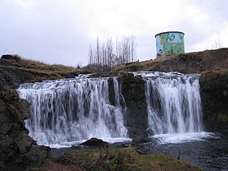
Álafoss is a waterfall on the river Varmá in Mosfellsbær, Iceland. A wool factory of the same name has adjoined the waterfall since 1896, when a local farmer imported machinery to process wool using the energy from the waterfall. During World War II, barracks were constructed there for British soldiers. Álafoss played a major role in the founding and growth of the town of Mosfellsbær. The band Sigur Rós has a studio named Sundlaugin at Álafoss, and the otherwise untitled fifth track on the band's "( )" album is nicknamed after the area.
San Pedro Lagunillas is both a municipality and the municipal seat of the same in the Mexican state of Nayarit. The population of the municipality was 7,155 (2005) in a total area of 520 square kilometers. The population of the town and municipal seat was 3,630 (2005). The population has been declining since 1980 when it was 8,308 inhabitants.

The Blue Mountain Tunnel is one of two tunnels through Blue Mountain in Pennsylvania, located west of Newburg. It is one of seven tunnels completed for the Pennsylvania Turnpike mainline, and at 4,339 ft (1,323 m) in length, is the shortest of the four still in use today. The Blue Mountain Tunnel is 600 ft (180 m) to the east of the Kittatinny Mountain Tunnel, separated by the Gunter Valley. It was originally completed in 1940 with only one two lane section. An additional section was added in the 1960s carrying two additional lanes.

Lagunilla is a station along Line B of the Mexico City Metro located north of the center of Mexico City, near the famous market with the same name.

Ahuacatlán is both a municipality and a municipal seat in the Mexican state of Nayarit. It is located in the southeastern part of the state and has boundaries with the following municipalities: in the north with San Pedro Lagunillas, Santa María del Oro and Jala; in the south with the state of Jalisco and the municipality of Amatlán de Cañas; in the east with Ixtlán del Río, Jala and Amatlán de Cañas; and in the west with San Pedro Lagunillas.
Lagunilla del Jubera is a municipality in the autonomous community of La Rioja, northern Spain, located in the Jubera River valley 19 kilometers from the capital, Logroño. Its population in the 2011 census was 325, and its area is 34.3 square kilometres (13.2 sq mi). The town has a Mediterranean climate, with hot dry summers and cold winters. Although agriculture has declined in the area, grains and grapes are still grown and livestock raised on a small scale.
The municipality of Lagunillas is located in the state of Michoacán. Its municipal seat is Lagunillas, Michoacán. It is bordered on the north and east by Morelia, south and west with Huiramba and Tzintzuntzan. Its distance from the state capital is 30 kilometers by the federal highway Morelia-Patzcuaro number 14. Lagunillas owes its name to the system of lakes and ponds that existed in ancient times in the region. During the colony a population center type hacendario. This place was called “Hacienda de Lagunillas”. By running the years the economic and social life revolved around the farm until the year of 1930 when “La Reforma Agraria” took place.

The Eje Central, or Avenida Lázaro Cárdenas, is a street in the Cuauhtémoc borough of central Mexico City.
Krępa is a village in the administrative district of Gmina Dobrzyń nad Wisłą, within Lipno County, Kuyavian-Pomeranian Voivodeship, in north-central Poland.

Earlston railway station, in the Scottish Borders village of Earlston, was a station on the now disused Berwickshire Railway.There were two platforms and two sidings, cattle dock and goods shed. The station closed to passenger traffic in 1948, and the last freight service operated on Friday 16 July 1965. The station closed completely, along with the line, on Monday 19 July 1965.
Lagunillas is a rural town in the municipality of San Martín de Hidalgo in the Mexican state of Jalisco. The town is enclaved in the local and statewide touristic area Sierra de Quila, one of Jalisco's largest protected forests.
Governador Newton Bello is a municipality in the state of Maranhão in the Northeast region of Brazil.

Maravilhas is a municipality in the state of Minas Gerais in the Southeast region of Brazil.
Contenda is a municipality in the state of Paraná in the Southern Region of Brazil.

Colonia Peralvillo is a colonia located in the Cuauhtémoc borough of Mexico City, just northwest of the city's historic center. It has been a poor area since colonial times, but the modern colonia was not established until the late 19th and early 20th centuries. Although the area has been the setting for a number of literary works and films, today the area is known for violence and crime, especially shootings and the selling of stolen auto parts.

La Lagunilla Market is a traditional public market in Mexico City, located about ten blocks north of the city’s main plaza, in a neighborhood called La Lagunilla. The market is one of the largest in the city and consists of three sections: one for clothing, one for furniture and one for foodstuffs, mostly selling to lower income customers. The market is surrounded by small stores and street vendors, many specializing in furniture and dresses and other needs for formal occasions. On Sundays, the number of street vendors grows significantly, a weekly “tianguis” market called a baratillo which traditionally sells used items. One section of this baratillo has developed into a market for antiques, which has attracted higher income customers and even famous ones such as Carlos Monsiváis.
Setti Fatma is a small town and rural commune in Al Haouz Province of the Marrakesh-Tensift-El Haouz region of Morocco. At the time of the 2004 census, the commune had a total population of 22283 people living in 3503 households.
There is a significant Roma population in Mexico, most being the descendants of past migrants. According to data collected by the National Institute of Statistics and Geography in 2000, they numbered 15,850, however, the total number is likely larger. In Mexico, they are commonly known as gitanos or rom.

Limay Mahuida Department is a department of Argentina in La Pampa Province. The capital city of the department is Limay Mahuida.


