Bolivia is a country in South America, bordered by Brazil to the north and east, Paraguay and Argentina to the south, Chile to the west, and Peru to the west.

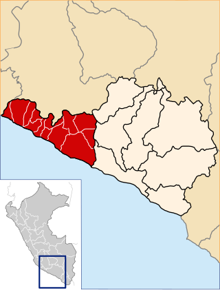
Santa Cruz is the largest of the nine constituent departments of Bolivia, occupying about one-third (33.74%) of the country's territory. With an area of 370,621 km2 (143,098 sq mi), it is slightly smaller than Japan or the US state of Montana. It is located in the eastern part of the country, sharing borders in the north and east with Brazil and with Paraguay in the south.
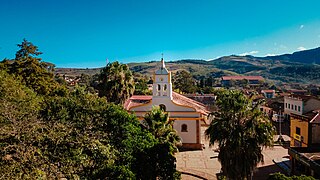
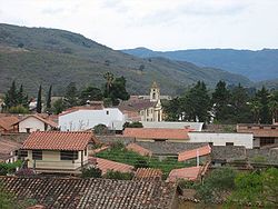
Samaipata or Samaypata is a small town in the Florida Province of the Santa Cruz Department in Bolivia. It has a subtropical climate and an altitude of 1600–1800 m. It lies about 120 kilometers to the southwest of the city of Santa Cruz de la Sierra in the foothills of the Andes on the way to Sucre. It is a popular resort for the inhabitants of Santa Cruz due to its cool climate. As such, there is a regular bus and taxi service to Santa Cruz. The town is small with numerous colonial buildings and narrow cobbled streets. It is located close to several tourist attractions such as El Fuerte de Samaipata, the Amboro National Park, El Codo de los Andes, Cuevas waterfalls, vineyards, rapids and lagoons, as well as well-preserved colonial towns such as Vallegrande, Pampagrande, Postrervalle, Santiago del Valle, Pucará, and others. It is also the first stop in the several tourist trails to Sucre, Potosi, and the Che Guevara route.

Santa Brígida is a municipality in the northeastern part of the island of Gran Canaria in the Province of Las Palmas of the Canary Islands. Its population is 18,791 (2013), and the area is 23.81 km2. It borders Las Palmas to the west and is part of its urban area.

Agüimes is a Spanish town and municipality in the eastern part of the island of Gran Canaria in the Las Palmas province in the Canary Islands.
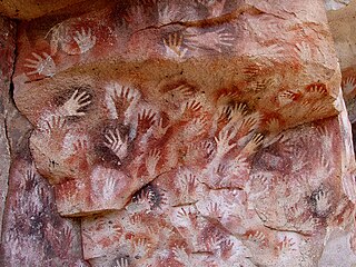
Cueva de las Manos is a cave and complex of rock art sites in the province of Santa Cruz, Argentina, 163 km (101 mi) south of the town of Perito Moreno. It is named for the hundreds of paintings of hands stenciled, in multiple collages, on the rock walls. The art was created in several waves between 7,300 BC and 700 AD, during the Archaic period of pre-Columbian South America. The age of the paintings was calculated from the remains of bone pipes used for spraying the paint on the wall of the cave to create the artwork, radiocarbon dating of the artwork, and stratigraphic dating.

El Fuerte de Samaipata or Fort Samaipata, also known simply as "El Fuerte", is a Pre-Columbian archaeological site and UNESCO World Heritage Site located in Florida Province, Santa Cruz Department, Bolivia. It is situated in the eastern foothills of the Bolivian Andes and is a popular tourist destination for Bolivians and foreigners alike. It is served by the nearby town of Samaipata. The archaeological site at El Fuerte is unique as it encompasses buildings of three different cultures: Chanè, Inca, and Spanish.

National Route 40, also known as RN40 or "Ruta 40", is a route in western Argentina, stretching from Cabo Vírgenes near Río Gallegos in Santa Cruz Province in the south to La Quiaca in Jujuy Province in the north with approximately 5194 km length. The route parallels the Andes mountains. The southern part of the route, by now largely paved, has become a well-known adventure tourism journey, and there are plans to pave the whole road.
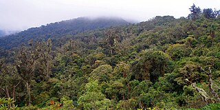
Amboró National Park in central Bolivia is a nature reserve with over 912 species of birds, over 177 mammalian species including puma, ocelot, and the rare spectacled bear. Covering an area of 4,425 km², it is protected from human settlements, hunting, mining and deforestation, though problems with all these still exist within the park. The Carrasco National Park is placed adjacent to Amboró, and together the two form a larger conservation unit.
Caravelí Province is one of eight provinces in the Arequipa Region of Peru, with its capital in the city of Caravelí. It borders the Ayacucho department to the north; the provinces of La Unión, Condesuyos, and Camaná to the east; the Pacific Ocean to the south; and the Ica department to the west.
Píñar is a municipality located in the province of Granada, Spain. It is located at 46 km from Granada, and 11 km from Iznalloz, capital of the Comarca of Los Montes Orientales.

Chané is the collective name for the southernmost Arawakan-speaking peoples. They lived in the plains of the northern Gran Chaco and in the foothills of the Andes in Paraguay, Brazil, Bolivia, and Argentina. The historical Chané are divided into two principal groups: the Chané proper who lived in eastern Bolivia, and the Guaná who lived in Paraguay and adjacent Brazil. Twenty-first century survivors of the Chané are the Izoceno people of Bolivia and 3,034 descendants reported in Argentina by the 2010 census. Survivors of the Guaná are the Tereno and the Kinikinao both of Mato Grosso do Sul province in Brazil.
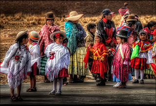
Tourism in Bolivia is one of the key economic sectors of the country. According to data from the National Institute of Statistics of Bolivia (INE), there were over 1.24 million tourists that visited the country in 2020, making Bolivia the ninth most visited country in South America.
Omereque is a location in the Cochabamba Department in central Bolivia. It is the seat of the Omereque Municipality, the third municipal section of the Narciso Campero Province.

Inka Mach'ay is an archaeological site in Bolivia. It is situated in the Chuquisaca Department, Oropeza Province, Sucre Municipality, at a height of 3,510 metres (11,516 ft). Inka Mach'ay was declared a National Monument on May 27, 1958, by Supreme Decrete No. 4954.

The Guayadeque ravine, in Spanish Barranco de Guayadeque, is a ravine-type valley located on the Spanish municipalities of Ingenio and Agüimes, in the province of Las Palmas on Grand Canary island, off the coast of Morocco.