Tarawa

Last updated

Tarawa
South Tarawa (north and south labeled).svg
Map of South Tarawa and North Tarawa within Tarawa Atoll
GilbertIslandsPos.png
Map of the Gilbert Islands
Kiribati location map.svg
Red pog.svg
Tarawa
Tarawa
Micronesia regions map.png
Red pog.svg
Tarawa
Tarawa (Micronesia)
Oceania laea location map.svg
Red pog.svg
Tarawa
Tarawa (Oceania)
Pacific Ocean laea location map.svg
Red pog.svg
Tarawa
Tarawa (Pacific Ocean)
Geography
Location Pacific Ocean
Coordinates 1°20′N173°00′E / 1.333°N 173.000°E / 1.333; 173.000 (Tarawa)
Archipelago Gilbert Islands
Area31.02 km2 (11.98 sq mi)
Highest elevation3 m (10 ft)
Administration
Kiribati
Island councils Betio, North Tarawa, South Tarawa
Largest settlement Betio
Demographics
Population70,480 (2020)
Pop. density2,031.5/km2 (5261.6/sq mi)
Languages Gilbertese
Ethnic groups I-Kiribati (95.5%)
Additional information
Time zone

Tarawa is an atoll and the capital of the Republic of Kiribati, [1] [2] [3] in the Micronesia region of the central Pacific Ocean. It comprises North Tarawa, which has 6,629 inhabitants and much in common with other more remote islands of the Gilbert group, and South Tarawa, which has 56,388 inhabitants as of 2015, half of the country's total population. [4] [5] The atoll was the site of the Battle of Tarawa during World War II.

Contents

Etymology

Tarawa is an old Gilbertese form for Te Rawa, meaning "The Passage" (of the Lagoon), named for the unusual large ship channel to the lagoon. [6] In the popular etymology based on Kiribati mythology, Nareau, the God-spider, distinguished Karawa, the sky, from Marawa, the Sea, from Tarawa, the land.

Geography

Tarawa has a large lagoon, 500 square kilometres (193 square miles) in total area, and a wide reef. The lagoon is widely open to the ocean, with a large ship pass. Although naturally abundant in fish and shellfish of all kinds, marine resources are being strained by the large and growing population. Drought is frequent, but in normal years rainfall is sufficient to maintain breadfruit, papaya and banana trees as well as coconut and pandanus.

North Tarawa consists of a string of islets from Buariki in the north to Buota in the south. The islets are separated in places by wide channels that are best crossed at low tide, and there is a ferry service between Buota and Abatao. [7] Only Buota is connected by road to South Tarawa, via a bridge.

On South Tarawa, the construction of causeways has now created a single strip of land from Betio in the west to Tanaea in the northeast. [8]

Climate

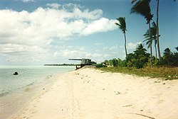
A tropical islet with palm fronds oriented in the direction of the prevailing winds. Line5304 - Flickr - NOAA Photo Library.jpg
A tropical islet with palm frond s oriented in the direction of the prevailing winds.

Tarawa features a tropical rainforest climate under the Köppen climate classification. The climate is pleasant from April to October, with predominant northeastern winds and stable temperatures close to 30 °C (86 °F). From November to March, western gales bring rain and occasional cyclones. [2] [9] [10]

Precipitation varies significantly between islands. For example, the annual average is 3,000 mm (120 in) in the north and 500 mm (20 in) in the south of the Gilbert Islands. [9] Most of these islands are in the dry belt of the equatorial oceanic climatic zone and experience prolonged droughts. [10]

Climate data for Tarawa Airport (South Tarawa)
MonthJanFebMarAprMayJunJulAugSepOctNovDecYear
Record high °C (°F)35.0
(95.0)
33.0
(91.4)
35.0
(95.0)
34.5
(94.1)
34.5
(94.1)
33.5
(92.3)
34.5
(94.1)
34.5
(94.1)
34.5
(94.1)
35.0
(95.0)
35.0
(95.0)
35.0
(95.0)
35.0
(95.0)
Mean daily maximum °C (°F)30.7
(87.3)
30.6
(87.1)
30.7
(87.3)
30.7
(87.3)
30.8
(87.4)
30.8
(87.4)
30.9
(87.6)
31.0
(87.8)
31.1
(88.0)
31.2
(88.2)
31.3
(88.3)
30.9
(87.6)
30.9
(87.6)
Daily mean °C (°F)28.2
(82.8)
28.1
(82.6)
28.1
(82.6)
28.2
(82.8)
28.4
(83.1)
28.3
(82.9)
28.2
(82.8)
28.3
(82.9)
28.4
(83.1)
28.6
(83.5)
28.5
(83.3)
28.2
(82.8)
28.3
(82.9)
Mean daily minimum °C (°F)25.3
(77.5)
25.3
(77.5)
25.2
(77.4)
25.3
(77.5)
25.5
(77.9)
25.3
(77.5)
25.1
(77.2)
25.2
(77.4)
25.3
(77.5)
25.4
(77.7)
25.4
(77.7)
25.3
(77.5)
25.3
(77.5)
Record low °C (°F)21.5
(70.7)
22.5
(72.5)
22.5
(72.5)
22.5
(72.5)
21.0
(69.8)
21.0
(69.8)
21.0
(69.8)
21.5
(70.7)
22.5
(72.5)
22.0
(71.6)
22.5
(72.5)
22.0
(71.6)
21.0
(69.8)
Average precipitation mm (inches)271
(10.7)
218
(8.6)
204
(8.0)
184
(7.2)
158
(6.2)
155
(6.1)
168
(6.6)
138
(5.4)
120
(4.7)
110
(4.3)
115
(4.5)
212
(8.3)
2,052
(80.8)
Average precipitation days (≥ 0.3 mm)151214151514161815111017172
Average relative humidity (%)81808182818180797777798180
Mean monthly sunshine hours 220.1192.1207.7201.0229.4219.0229.4257.3243.0260.4240.0189.12,688.5
Mean daily sunshine hours 7.16.86.76.77.47.37.48.38.18.48.06.17.4
Source: Deutscher Wetterdienst [11]

Administration

Tarawa atoll has three administrative subdivisions: Betio Town Council (or BTC), on Betio Islet; Teinainano Urban Council  [ it ] (or TUC), from Bairiki to Tanaea; and Eutan Tarawa Council (or ETC), for North Tarawa or Tarawa Ieta, consisting of all the islets on the east side from Buota northwards. [12] The meaning of Te inainano in Gilbertese language is "down of the mast", alluding to the sail-shape of the atoll [13]

South Tarawa hosts the capital of the Republic of Kiribati and was also the central headquarters of the Gilbert and Ellice Islands since 1895. The House of Assembly is in Ambo, and the State House is in Bairiki. The offices of the various ministries of the government range from Betio at the south-west extreme to Nawerewere (on an easterly island in its chain), close to Bonriki (International Airport) and Temwaiku. Settlements on North Tarawa include Buariki, Abaokoro, Marenanuka and Taborio.

Diplomatic missions

Four resident diplomatic missions exist: the embassies of China (closed in 2003, re-opened in 2020) and Japan (opened in 2023), and the high commissions of Australia and New Zealand. The United Nations are also present in Kiribati, including UNICEF, UNDP, UNFPA, UNOPS, UN Women, WHO and FAO.

History

Japanese World War II defences on Tarawa Battle Tarawa.jpg
Japanese World War II defences on Tarawa

In Kiribati mythology, Tarawa was the earth when the land, ocean and sky had not been cleaved yet by Nareau the spider. Thus, after calling the sky karawa and the ocean marawa, he called the piece of rock that Riiki (another god that Nareau found) had stood upon when he lifted up the sky as, Tarawa. Nareau then created the rest of the islands in Kiribati and also Samoa.

Gilbertese arrived at these islands thousands of years ago, and there have been migrations to and from Gilbert Islands since antiquity. [14]

Evidence from a range of sources, including carbon dating and DNA analyses, confirms that the exploration of the Pacific included settlement of the Gilbert Islands by around 200 BC. The people of Tungaru (native name of the Gilbertese) are still excellent seafarers, capable of making ocean crossings in locally made vessels using traditional navigation techniques. [15]

Thomas Gilbert, captain of the East India Company vessel Charlotte, was the first European to describe Tarawa, arriving on 20 June 1788. He did not land. He named it Matthew Island, after the owner of his ship Charlotte. He named the lagoon Charlotte Bay. [16] Gilbert's 1788 sketches survive.

Map of Tarawa, from US Ex Ex survey in 1873 Tarawa 1873 map.jpg
Map of Tarawa, from US Ex Ex survey in 1873

The island was surveyed in 1841 by the US Exploring Expedition. [17]

For nine generations, the island was divided between two warring factions, the House of Auatubu and the House of Teabike, until in 1892 HMS Royalist (1883) arrived, with Captain Edward Davis proclaiming that the island was now a British Protectorate. This saved Auatubu from massacre; the day before, they had been badly defeated by Teabike. A very old lady, plaiting a sleeping mat twenty-five years later, described the situation:

"In those days death was on the right hand and on the left. If we wandered north, we were killed or raped. If we wandered south, we were killed or raped. If we returned alive from walking abroad, our husbands themselves killed us, for they said that we had gone forth seeking to be raped. That was indeed just, for a woman who disobeys her husband is a woman of no account, and it matters not how she dies. Yet how beautiful is life in our villages, now that there is no killing and war is no more... Behold my son and my grandson! These would have died with me that day at Nea if the warship had not arrived. And these"-she pointed out her great and great-great-grandchildren-"would never have been born. We live because the Government of Kuini Kabitoria brought peace to us, and here I sit plaiting this mat to be buried in because of the kindness of that woman, with all my generations around me to wrap me in it when I die." [18]

The aftermath of land claims and counter-claims between Auatubu and Teabike nevertheless caused high tension for years afterwards. [19]

Charles Richard Swayne, the first Resident Commissioner, decided to install the central headquarters of the Gilbert and Ellice Islands protectorate in Tarawa in 1895. Tarawa Post Office opened on 1 January 1911. [20]

Sir Arthur Grimble was a cadet administrative officer based at Tarawa (1913–1919). [21] He became Resident Commissioner of the Gilbert and Ellice Islands colony in 1926. [22]

With the Marines at Tarawa documentary film, 1944 (0:20:10)

During World War II, Tarawa was occupied by the Japanese, and beginning on 20 November 1943 it was the scene of the bloody Battle of Tarawa. On that day U.S. Marines landed on Tarawa and fought Japanese soldiers occupying entrenched positions on the atoll. The Marines captured the island after 76 hours of intense fighting that killed 6,000 people in total.

The fierce fighting was the subject of a documentary film produced by the Combat Photographers of the Second Marine Division entitled With the Marines at Tarawa . It was released in March 1944 at the insistence of President Roosevelt. It became the first time many Americans viewed American servicemen dead on film.[ citation needed ]. The US built bases on the Island.

The Kiribati Government began a road restoration project funded in part by the World Bank in 2014 to re-surface the main road from Betio in the west to Bonriki in the east, [23] upgrading the main road that transits Tarawa from a dirt road. As of 2018, all that remained to be completed of this project was the sealing of the Japanese Causeway, connecting Bairiki and Betio, done in 2019.

Literature and journal

Memorial

See also

Related Research Articles

<span class="mw-page-title-main">Kiribati</span> Country in the central Pacific Ocean

Kiribati, officially the Republic of Kiribati, is an island country in the Micronesia subregion of Oceania in the central Pacific Ocean. Its permanent population is over 119,000 as of the 2020 census, with more than half living on Tarawa atoll. The state comprises 32 atolls and one remote raised coral island, Banaba. Its total land area is 811 km2 (313 sq mi) dispersed over 3,441,810 km2 (1,328,890 sq mi) of ocean.

<span class="mw-page-title-main">History of Kiribati</span> Historical development of Kiribati

The islands which now form the Republic of Kiribati have been inhabited for at least seven hundred years, and possibly much longer. The initial Austronesian peoples’ population, which remains the overwhelming majority today, was visited by Polynesian and Melanesian invaders before the first European sailors visited the islands in the 17th century. For much of the subsequent period, the main island chain, the Gilbert Islands, was ruled as part of the British Empire. The country gained its independence in 1979 and has since been known as Kiribati.

<span class="mw-page-title-main">Gilbert Islands</span> 1976–1979 British colony in the Pacific

The Gilbert Islands are a chain of sixteen atolls and coral islands in the Pacific Ocean, about halfway between Papua New Guinea and Hawaii. They constitute the main part of the nation of Kiribati.

<span class="mw-page-title-main">Gilbert and Ellice Islands</span> 1892–1976 British colony in the Pacific

The Gilbert and Ellice Islands in the Pacific Ocean were part of the British Empire from 1892 to 1976. They were a protectorate from 1892 to 12 January 1916, and then a colony until 1 January 1976, and were administered as part of the British Western Pacific Territories (BWPT) until they became independent. The history of GEIC was mainly characterized by phosphate mining on Ocean Island. In October 1975, these islands were divided by force of law into two separate colonies, and they became independent nations shortly thereafter: the Ellice Islands became Tuvalu in 1978, and the Gilbert Islands became part of Kiribati in 1979.

<span class="mw-page-title-main">Tabiteuea</span> Atoll in the Gilbert Islands, Kiribati

Tabiteuea is an atoll in the Gilbert Islands, Kiribati, farther south of Tarawa. This atoll is the second largest and the most populated of the Gilbert Islands after Tarawa. The atoll consists of one main island, Aanikai in the north, and several smaller islets in between along the eastern rim of the atoll. The atoll has a total land area of 38 km2 (15 sq mi), while the lagoon measures 365 km2 (141 sq mi). The population numbered 5,261 in 2015. The islanders have customary fishing practices related to the lagoon and the open ocean.

<span class="mw-page-title-main">Butaritari</span> Atoll in the Pacific Ocean island nation of Kiribati

Butaritari is an atoll in the Pacific Ocean island nation of Kiribati. The atoll is roughly four-sided. The south and southeast portion of the atoll comprises a nearly continuous islet. The atoll reef is continuous but almost without islets along the north side. Bikati and Bikatieta islets occupy a corner of the reef at the extreme northwest tip of the atoll. Small islets are found on reef sections between channels on the west side. The lagoon of Butaritari is deep and can accommodate large ships, though the entrance passages are relatively narrow. It is the most fertile of the Gilbert Islands, with relatively good soils and high rainfall. Butaritari atoll has a land area of 13.49 km2 (5.21 sq mi) and a population of 3,224 as of 2015. During World War II, Butaritari was known by United States Armed Forces as Makin Atoll, and was the site of the Battle of Makin. Locally, Makin is the name of a separate but closest atoll, 3 kilometres to the northeast of Butaritari, but close enough to be seen. These two atolls share a dialect of the Gilbertese language.

<span class="mw-page-title-main">Bairiki</span> Town in Gilbert Islands, Kiribati

Bairiki is a town located in South Tarawa, Kiribati. It is crucial to the country's political and administrative structure as several governmental organizations and diplomatic missions are situated there.

<span class="mw-page-title-main">South Tarawa</span> Island of the Republic of Kiribati

South Tarawa is the capital and hub of the Republic of Kiribati and home to more than half of Kiribati's population. The South Tarawa population centre consists of all the small islets from Betio in the west to Bonriki and Tanaea in the north-east, connected by the South Tarawa main road, with a population of 63,439 as of 2020.

<span class="mw-page-title-main">Betio</span> Town in Gilbert Islands, Kiribati

Betio is the largest township of Kiribati's capital city, South Tarawa, and the country's main port. The settlement is located on a separate islet at the extreme southwest of the atoll.

<span class="mw-page-title-main">Beru (atoll)</span>

Beru is an atoll in the Southern Gilbert Islands in the Pacific Ocean, part of the Republic of Kiribati. Beru was previously known as Eliza, Francis Island, Maria, Peroat, Peru Island or Sunday. It's part of a larger reef with the Nuka Lagoon at its center, and the nearest island is Nikunau. The Tabiang Lagoon is present in the north. Beru is home to 2,051 inhabitants. Due to sea surges, the atoll is experiencing coastal erosion along with damages to seawalls.

<span class="mw-page-title-main">Kuria (atoll)</span> Atoll in Central Gilbert Islands, Kiribati

Kuria is an atoll, formed by a pair of islets, in the Central Gilbert Islands in Kiribati, northwest of Aranuka. The two islets, Buariki and Oneeke, are separated by a 20 metre wide channel on a shallow water platform, which is crossed by a bridge of the connecting road. The islands are surrounded by fringing reef which is broadest on the eastern side of Kuria. The population of Kuria was 1,046 in 2015.

<span class="mw-page-title-main">Maiana</span> Atoll in Gilbert Islands, Kiribati

Maiana is an atoll in Kiribati and is one of the Central Gilbert Islands. Maiana is 44 kilometres (27 mi) south of the capital island of South Tarawa and has a population of 1,982 as of 2015. The northern and eastern sides of the atoll are a single island, whilst the western edge consists of submerged reefs and many uninhabited islets, all surrounding a lagoon. The atoll is 14 kilometres (8.7 mi) long and is very narrow, with an average width of less than 1 kilometre (0.62 mi) and a total land area of 16.72 square kilometres (6.46 sq mi).

<span class="mw-page-title-main">Marakei</span>

Marakei is a small atoll in the North Gilbert Islands. It consists of a central lagoon with numerous deep basins, surrounded by two large islands separated by two narrow channels. The atoll covers approximately 40 square kilometres (15 sq mi).

<span class="mw-page-title-main">Nikunau</span>

Nikunau is a low coral atoll in the Gilbert Islands that forms a council district of the Republic of Kiribati. It consists of two parts, with the larger in the northwest, joined by an isthmus about 150 metres (490 ft) wide.

<span class="mw-page-title-main">Onotoa</span>

Onotoa is an atoll of Kiribati. It is situated in the Gilbert Islands in the Pacific Ocean, 65 km (40 mi) from Tamana, the smallest island in the Gilberts. The population of Onotoa in the 2015 census was 1,393.

<span class="mw-page-title-main">Makin (atoll)</span>

Makin is the name of an atoll, chain of islands, located in the Pacific Ocean island nation of Kiribati. Makin is the northernmost of the Gilbert Islands, with a population of 1,990.

<span class="mw-page-title-main">Bikenibeu</span> Place in Gilbert Islands, Kiribati

Bikenibeu is a settlement in Kiribati. It is located close to the southeastern corner of the Tarawa atoll, part of the island country of Kiribati. It is part of a nearly continuous chain of settlements along the islands of South Tarawa, which are now linked by causeways. The low-lying atoll is vulnerable to sea level rise. Rapid population growth has caused some environmental problems. Kiribati's main government high school, King George V and Elaine Bernachi School, is located in Bikenibeu, as well as the Ministries of Environment and Education.

<span class="mw-page-title-main">North Tarawa</span> A string of islets in Kiribati governed by the Eutan Tarawa Council

North Tarawa or in Gilbertese Tarawa Ieta, in the Republic of Kiribati, is the string of islets from Buariki at the northern tip of Tarawa atoll to Buota in the South, with a combined population of 6,629 as of 2015. It is administratively separate from neighbouring South Tarawa, and is governed by the Eutan Tarawa Council (ETC), based at Abaokoro.

<span class="mw-page-title-main">Governor of the Gilbert and Ellice Islands</span> Colonial head of the Gilbert and Ellice Islands civil service (1892–1979)

The Governor of the Gilbert and Ellice Islands was the colonial head of the Gilbert and Ellice Islands civil service from 1892 until 1979.

Vivian Fox-Strangways was a British officer, Resident Commissioner of the partly occupied by Japan Gilbert and Ellice Islands, from 1941 to 1946.

References

  1. "Kiribati government website". Government of Kiribati. Archived from the original on 26 June 2010. Retrieved 29 May 2014.
  2. 1 2 Kiribati. The World Factbook . Central Intelligence Agency.
  3. "European Union – list of countries in the world".
  4. Country files at earth-info.nga.mil Archived 12 August 2005 at the Wayback Machine
  5. "Kiribati Census Report 2015 Volume 1" (PDF). National Statistics Office, Ministry of Finance and Economic Development, Government of Kiribati. Archived from the original (PDF) on 30 September 2013. Retrieved 17 March 2013.
  6. Rawa. n. a passage, canal, passage through reef, a strait. Ernest Sabatier, Dictionnaire gilbertin-français, 1952.
  7. "North Tarawa Island Report 2012". Government of Kiribati.
  8. "South Tarawa Island Report 2012". Government of Kiribati.
  9. 1 2 Kiribati. Encyclopædia Britannica
  10. 1 2 Thomas, 3
  11. "Klimatafel von Tarawa, Int. Flugh. Bonriki / Kiribati (Gilbert-Inseln)" (PDF). Baseline climate means (1961–1990) from stations all over the world (in German). Deutscher Wetterdienst. Retrieved 30 November 2020.
  12. Dr Temakei Tebano & others (March 2008). "Island/atoll climate change profiles – Tarawaieta (North Tawara)". Office of Te Beretitent – Republic of Kiribati Island Report Series (for KAP II (Phase 2). Archived from the original on 6 November 2011. Retrieved 28 April 2015.
  13. "inainano: *B ináinano. n. lower sprit or brace of a canoe sail; *O inainano. n. the lower yard arm.", from Trussel Gilbertese dictionary).
  14. North Tarawa Socioeconomic Report 2008. Secretariat of the Pacific Community and Government of Kiribati
  15. Howe, K. R. (2006). Vaka Moana – voyages of the ancestors. David Bateman. ISBN   1869536258.
  16. Samuel Eliot Morison (22 May 1944). "The Gilberts & Marshalls: A distinguished historian recalls the past of two recently captured pacific groups". Life . Retrieved 14 October 2009. Being now abreast of this island, the extremity ending in a beautiful clump of trees, I hauled up to look at the bay. It appeared to be safe and commodious, sheltered by a long reef running parallel with the island, with two large inlets into the bay. The reef is about ¾ of a mile from the beach, and has several small islands which appear like flower pots.
  17. Stanton, William (1975). The Great United States Exploring Expedition. Berkeley: University of California Press. pp.  245. ISBN   0520025571.
  18. A Pattern of Islands. Arthur Grimble. The Reprint Society, by arrangement with John Murray (publishers) Ltd., 1954. First published 1952. Pages 178-180.
  19. A Pattern of Islands. Arthur Grimble. The Reprint Society, by arrangement with John Murray (publishers) Ltd., 1954. First published 1952. Pages 247-258.
  20. Premier Postal History. "Post Office List". Premier Postal Auctions. Retrieved 5 July 2013.
  21. Grimble, Sir Arthur (1952). "A Pattern of Islands". Early New Zealand Books (NZETC). Retrieved 16 October 2011.
  22. Grimble, Sir Arthur (2011). A Pattern of Islands. John Murray & Co, London, 1952; republished 2011 by Eland, London. ISBN   978-1-906011-45-1.
  23. "Projects : Kiribati Road Rehabilitation Project | The World Bank". Archived from the original on 12 November 2012.