
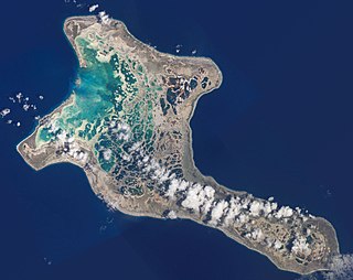
Kingman Reef is a largely submerged, uninhabited, triangle-shaped reef, geologically an atoll, 9.0 nmi (20 km) east-west and 4.5 nmi (8 km) north-south, in the North Pacific Ocean, roughly halfway between the Hawaiian Islands and American Samoa. It has an area of 3 hectares and is a unincorporated territory of the United States in Oceania. The reef is administered by the United States Fish and Wildlife Service as the Kingman Reef National Wildlife Refuge. It was claimed by the US in 1859 and later used briefly as a stopover for commercial Pacific flying boat routes in the 1930s going to New Zealand; however, the route was changed with a different stopover. It was administered by the Navy from 1934 to 2000 and thereafter by the Fish and Wildlife Service. It has since become a marine protected area. In the 19th century, it was noted as a maritime hazard, earning the name Hazard Rocks, and is known to have been hit once in 1876. In the 21st century, it has been noted for its marine biodiversity and remote nature. Hundreds of fish and coral species are on and around the reef.
Kiritimati, also known as Christmas Island, is a Pacific Ocean atoll in the northern Line Islands. It is part of the Republic of Kiribati. The name is derived from the English word "Christmas" written in Gilbertese according to its phonology, in which the combination ti is pronounced /s/.

The Line Islands, Teraina Islands or Equatorial Islands are a chain of 11 atolls and coral islands in the central Pacific Ocean, south of the Hawaiian Islands. Eight of the atolls are parts of Kiribati. The remaining three—Jarvis Island, Kingman Reef, and Palmyra Atoll—are territories of the United States grouped with the United States Minor Outlying Islands. The Line Islands, all of which were formed by volcanic activity, are one of the longest island chains in the world, stretching 2,350 km (1,460 mi) from northwest to southeast. One of them, Starbuck Island, is near the geographic center of the Pacific Ocean. Another, Kiritimati, has the largest land area of any atoll in the world. Only Kiritimati, Tabuaeran, and Teraina have a permanent population. Besides the 11 confirmed atolls and islands, Filippo Reef is shown on some maps, but its existence is doubted.
Malden Island, sometimes called Independence Island in the 19th century, is a low, arid, uninhabited atoll in the central Pacific Ocean, about 39 km2 (15 sq mi) in area. It is one of the Line Islands belonging to the Republic of Kiribati. The lagoon is entirely enclosed by land, though it is connected to the sea by underground channels, and is quite salty.
Nikumaroro, previously known as Kemins Island or Gardner Island, is a part of the Phoenix Islands, Kiribati, in the western Pacific Ocean. It is a remote, elongated, triangular coral atoll with profuse vegetation and a large central marine lagoon. Nikumaroro is about 7.5 km (4.7 mi) long by 2.5 km (1.6 mi) wide. The rim has two narrow entrances, both of which are blocked by a wide reef, which is dry at low tide. The ocean beyond the reef is very deep, and the only anchorage is at the island's west end, across the reef from the ruins of a mid-20th-century British colonial village, but this is safe only with the southeast trade winds. Landing has always been difficult and is most often done south of the anchorage. Although occupied at various times during the past, the island is uninhabited today.
The Phoenix Islands, or Rawaki, are a group of eight atolls and two submerged coral reefs that lie east of the Gilbert Islands and west of the Line Islands in the central Pacific Ocean, north of Samoa. They are part of the Republic of Kiribati. Their combined land area is 28 square kilometres (11 sq mi). The only island of any commercial importance is Canton Island. The other islands are Enderbury, Rawaki, Manra, Birnie, McKean, Nikumaroro, and Orona.

Canton Island, previously known as Mary Island, Mary Balcout's Island or Swallow Island, is the largest, northernmost, and as of 2020, the sole inhabited island of the Phoenix Islands, in the Republic of Kiribati. It is an atoll located in the South Pacific Ocean roughly halfway between Hawaii and Fiji. The island is a narrow ribbon of land around a lagoon; an area of 40 km2 (15 sq mi). Canton's closest neighbour is the uninhabited Enderbury Island, 63 km (39 mi) west-southwest. The capital of Kiribati, South Tarawa, lies 1,765 km (1,097 mi) to the west. As of 2015, the population was 20, down from 61 in 2000. The island's sole village, Tebaronga, is located on the northwest point, below the airstrip.
Starbuck Island is an uninhabited coral island in the central Pacific, and is part of the Central Line Islands of Kiribati. Its former names include "Barren Island", "Coral Queen Island", "Hero Island", "Low Island", and "Starve Island".

Vostok Island is an uninhabited coral island in the central Pacific Ocean, part of the Line Islands belonging to Kiribati. Other names for the island include Anne Island, Bostock Island, Leavitts Island, Reaper Island, Wostock Island or Wostok Island. The island was first sighted in 1820 by the Russian explorer Fabian Gottlieb von Bellingshausen, who named the island for his ship Vostok.

Caroline Island is the easternmost of several uninhabited coral atolls comprising the southern Line Islands in the central Pacific Ocean nation of Kiribati.

Teraina is a coral atoll in the central Pacific Ocean and part of the Northern Line Islands which belong to Kiribati. Obsolete names of Teraina are New Marquesas, Prospect Island, and New York Island. The island is located approximately 4.71° North latitude and 160.76° West longitude. Teraina differs from most other atolls in the world in that it has a large freshwater lake, an open lens, concealed within its luxuriant coconut palm forest; this is the only permanent freshwater lake in the whole of Kiribati.

Enderbury Island, also known as Ederbury Island or Guano Island, is a small, uninhabited atoll 63 km ESE of Kanton Island in the Pacific Ocean at 3°08′S171°05′W. It is about 1 mile (1.6 km) wide and 3 miles (4.8 km) long, with a reef stretching out 60–200 metres. Forming a part of the Canton and Enderbury Islands condominium from 1939 to 1979, the island is now a possession of the Republic of Kiribati.

The Canton and Enderbury Islands consist of the coral atolls of Canton Island and Enderbury in the northeastern part of the Phoenix Islands, about 1,850 miles (3,000 km) south of Hawaii in the central Pacific Ocean.

Birnie Island is a small, uninhabited coral island, 20 hectares in area, part of the Phoenix Island group, that is part of the Republic of Kiribati. It is located about 100 kilometres southeast of Kanton Island and 90 kilometres west-northwest of Rawaki Island, formerly known as Phoenix Island. It lies at 03°35′S171°33′W. Birnie Island measures only 1.2 kilometres (0.75 mi) long and 0.5 kilometres (0.3 mi) wide. There is no anchorage, but landing can be made on the lee shore.
Winslow Reef is an underwater feature of the Phoenix Islands, Republic of Kiribati, located 200 kilometres (120 mi) north-northwest of McKean Island at 01°36′S174°57′W. It is the northernmost and westernmost feature of the Phoenix Islands, not counting the outlying Baker and Howland Islands. It has a least depth of 11 m (36 ft). The reef is about 1.6 km (1 mi) long east–west, and about half that wide. The bottom is pink coral and red sand.

McKean Island is a small, uninhabited island in the Phoenix Islands, Republic of Kiribati. Its area is 57 hectares.

Manra, is one of the Phoenix Islands in the Republic of Kiribati. It lies at 4°27′S171°16′W. longitude, and has an area of 4.4 km2 (1.7 sq mi). and an elevation of approximately six metres. Together with the seven other Phoenix Islands, it forms part of the Phoenix Islands Protected Area,. Charles Darwin visited the island during his five-year voyage (1831-1836), following which in 1842 he published an explanation for the creation of coral atolls in the South Pacific.

Orona atoll, also known as Hull Island, is one of the Phoenix Islands in the Republic of Kiribati. It measures approximately 8.8 km (5 mi) by 4 km (2 mi), and like Kanton, is a narrow ribbon of land surrounding a sizable lagoon with depths of 15–20 metres (49–66 ft). Numerous passages connect the lagoon to the surrounding ocean, only a couple of which will admit even a small boat. Total land area is 3.9 km2 (2 sq mi), and the maximum elevation is nine metres.

The Phoenix Islands Protected Area (PIPA) is located in the Republic of Kiribati, an ocean nation in the central Pacific approximately midway between Australia and Hawaii. PIPA constitutes 11.34% of Kiribati's exclusive economic zone (EEZ), and with a size of 408,250 km2 (157,630 sq mi), it is one of the largest marine protected areas (MPA) and one of the largest protected areas of any type on Earth. The PIPA was also designated as the world's largest and deepest UNESCO World Heritage Site in 2010.
The Coral reefs of Kiribati consists of 32 atolls and one raised coral island, Banaba, which is an isolated island between Nauru and the Gilbert Islands. The islands of Kiribati are dispersed over 3.5 million km2 (1.4 million sq mi) of the Pacific Ocean and straddle the equator and the 180th meridian, extending into the eastern and western hemispheres, as well as the northern and southern hemispheres. 21 of the 33 islands are inhabited. The groups of islands of Kiribati are:


