Kuria (atoll)

Last updated
Kuria
9 Map of Kuria, Kiribati.jpg
Map of Kuria
GilbertIslandsPos.png
Kiribati location map.svg
Red pog.svg
Kuria
Micronesia regions map.png
Red pog.svg
Kuria
Oceania laea location map.svg
Red pog.svg
Kuria
Pacific Ocean laea location map.svg
Red pog.svg
Kuria
Geography
Location Pacific Ocean
Coordinates 0°13′43″N173°24′38″E / 0.22861°N 173.41056°E / 0.22861; 173.41056 (Kuria) Coordinates: 0°13′43″N173°24′38″E / 0.22861°N 173.41056°E / 0.22861; 173.41056 (Kuria)
Archipelago Gilbert Islands
Area15.48 km2 (5.98 sq mi)
Highest elevation3 m (10 ft)
Administration
Demographics
Population1,046 (2015 Census)
Pop. density63/km2 (163/sq mi)
Ethnic groups I-Kiribati 100%

Kuria is an atoll, formed by a pair of islets, in the Central Gilbert Islands in Kiribati, northwest of Aranuka. The two islets, Buariki and Oneeke, are separated by a 20 metre wide channel on a shallow water platform (Te buriiti), which is crossed by a bridge of the connecting road. The islands are surrounded by fringing reef which is broadest on the eastern side of Kuria. The population of Kuria was 1,046 in 2015. [1]

Contents

Geography

View from the air Kiribati Kuria Islands.jpg
View from the air

Kuria is made up of two islets, which are reef islands as they do not have a lagoon. The main islet, Buariki, has five villages; Marenaua, Bouatoa, Buariki, Tabontebike and Norauea. These villages are connected to the smaller islet of Oneeke by a ten-metre (33 ft) bridge replacing the old causeway that ran across the former reef passage between the two islets. The two islets are relatively wide as compared to most islands in the Gilbert group. The widest portion measures 4.26 km (2.65 mi) from lagoon to the ocean side and the length from north to south is 8.94 km (5.56 mi). There are two natural brackish-water ponds at east-southern tip of the main islet. The total land area of Kuria is of 15.48 km2 (5.98 sq mi), which is close to the average size for an island of Kiribati, but the population in 2010 was only 980 people, making Kuria one of the least densely populated islands in Kiribati. [1]

The main administration center is located at Buariki, and the airport, police headquarters, guest house and Junior Secondary School are also located here. [1]

Villages

Kuria: Population and Land Area
Census AreaPopulation 2010 [2] Land area by islet [2] Density (people per hectare)
Oneeke154525 hectares (1,297 acres)0.3
Manenaua1911,022.7 hectares (2,527 acres)0.8
Tabontebike91
Buariki169
Norauea247
Bouatoa128
Kuria total9801,547.7 hectares (3,824 acres)0.6

History

Dancers welcome important visitors to Kuria Kuria dancers.JPG
Dancers welcome important visitors to Kuria

Kuria means 'almost seen on the horizon'. [3] [Note 1] Thomas Gilbert and John Marshall, sailing in the merchant ships Charlotte and Scarborough, were the first Europeans to describe visiting Kuria, in June 1788. [6]

The islands were surveyed in 1841 by the US Exploring Expedition. [7]

In the 1840s, the islands of Kuria and Aranuka were conquered by Tenkoruti or Karotu, the paramount chief or the Uea (king) of Abemama, when a former ruler (Ten Temea) of Kuria and Aranuka gave up these two islands to King Karotu from Abemama and left for Maiana, another of the Gilbert group. [3] In 1878 Tenkoruti's nephew, Tembinok' or Tem Binoka became the Uea. [3] [8] He acquired firearms and manufactured goods from traders and he purchased a ship. To pay for his acquisitions he tightened his control over the 3 islands in order to increase his supply of coconuts and other produce, which he sold to the traders. [3] Tembinok' was immortalised by Robert Louis Stevenson's description of him in his book In the South Seas. Robert Louis Stevenson spent two months on Abemama in 1889. Stevenson described Tembinok' as the "one great personage in the Gilberts … and the last tyrant". [9]

In early European times, animals in Kuria were not considered a welcome addition to the ecosystem. As a result, introduced animals were considered a subject of supernatural fears and were slaughtered and thrown into the lagoon. [10]

Kuria Post Office opened around 1912. [11]

Tourism

Air Kiribati operates two flights per week from South Tarawa, linking with neighbouring Aranuka Airport. Boat charters are also available.

The Island Council operates a guest house, where tourists are welcome, although it is advisable to be prepared as the island is very isolated.

Dress code is restricted on Kuria. Casual wear is preferable and women are not allowed to walk around with bikinis, mini skirts or shorts. A skirt/short covered down to your knees or wrapped around lava-lava and T-shirts are preferable. [10]

Notes

  1. Sir Arthur Grimble, cadet administrative officer in the Gilberts from 1914 and resident commissioner of the Gilbert and Ellice Islands colony from 1926, recorded the myths and oral traditions of the Kiribati people. He wrote the best-sellers A Pattern of Islands (London, John Murray 1952, [4] and Return to the Islands (1957), which was republished by Eland, London in 2011, ISBN   978-1-906011-45-1. He also wrote Tungaru Traditions: writings on the atoll culture of the Gilbert Islands, University of Hawaii Press, Honolulu, 1989, ISBN   0-8248-1217-4. [5]

Related Research Articles

In the Micronesian mythology of Kiribati Uekera is a tree that reaches to the heavens; Te Kaintikuaba which is translated as the "tree of life" or "tree of knowledge" in Kiribati legend. It is said to have been planted in Buariki village in North Tarawa by Nei Tekanuea. The creation story is that spirits who lived in Te Kaintikuaba in Samoa, migrated northward carrying branches from the tree and created the islands of Tungaru. It is the inspiration for the name of the Kiribati weekly newspaper, Te Uekera.

<span class="mw-page-title-main">Gilbert Islands</span> Chain of sixteen atolls and coral islands in the Pacific Ocean

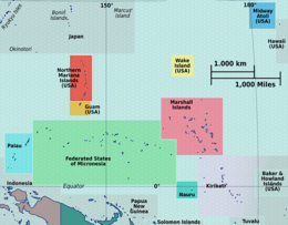
The Gilbert Islands are a chain of sixteen atolls and coral islands in the Pacific Ocean, about halfway between Papua New Guinea and Hawaii. They constitute the main part of the nation of Kiribati.

<span class="mw-page-title-main">Tamana, Kiribati</span> Island of Kiribati

Tamana is the smallest island in the Gilbert Islands. It is accessible both by boat and by air with Air Kiribati and Coral Sun Airways. 1,054 people live in Tamana.

<span class="mw-page-title-main">Tabiteuea</span> Atoll in the Gilbert Islands, Kiribati

Tabiteuea is an atoll in the Gilbert Islands, Kiribati, farther south of Tarawa. This atoll is the bigger and the most populated of the Gilbert Islands but Tarawa. The atoll consists of one main island, Aanikai in the north, and several smaller islets in between along the eastern rim of the atoll. The atoll has a total land area of 38 km2 (15 sq mi), while the lagoon measures 365 km2 (141 sq mi). The population numbered 5,261 in 2015. The islanders have customary fishing practices related to the lagoon and the open ocean.

<span class="mw-page-title-main">Butaritari</span> Atoll in the Pacific Ocean island nation of Kiribati

Butaritari is an atoll in the Pacific Ocean island nation of Kiribati. The atoll is roughly four-sided. The south and southeast portion of the atoll comprises a nearly continuous islet. The atoll reef is continuous but almost without islets along the north side. Bikati and Bikatieta islets occupy a corner of the reef at the extreme northwest tip of the atoll. Small islets are found on reef sections between channels on the west side. The lagoon of Butaritari is deep and can accommodate large ships, though the entrance passages are relatively narrow. It is the most fertile of the Gilbert Islands, with relatively good soils and high rainfall. Butaritari atoll has a land area of 13.49 km2 (5.21 sq mi) and a population of 3,224 as of 2015. During World War II, Butaritari was known by United States Armed Forces as Makin Atoll, and was the site of the Battle of Makin. Locally, Makin is the name of a separate but closest atoll, 3 kilometres to the northeast of Butaritari, but close enough to be seen. These two atolls share a dialect of the Gilbertese language.

<span class="mw-page-title-main">Tarawa</span> Atoll in the South Pacific

Tarawa is an atoll and the capital of the Republic of Kiribati, in the Micronesia region of the central Pacific Ocean. It comprises North Tarawa, which has 6,629 inhabitants and much in common with other more remote islands of the Gilberts group, and South Tarawa, which has 56,388 inhabitants as of 2015, half of the country's total population. The atoll was the site of the Battle of Tarawa during World War II.

<span class="mw-page-title-main">Abemama</span> Atoll of Kiribati

Abemama (Apamama) is an atoll, one of the Gilberts group in Kiribati, and is located 152 kilometres southeast of Tarawa and just north of the Equator. Abemama has an area of 27.37 square kilometres and a population of 3,299 as of 2015. The islets surround a deep lagoon. The eastern part of the atoll of Abemama is linked together by causeways making automobile traffic possible between the different islets. The outlying islands of Abatiku and Biike are situated on the southwestern side of the atoll.

<span class="mw-page-title-main">Aranuka</span>

Aranuka is an atoll of Kiribati, located just north of the equator, in the Gilbert Islands. It has an area of 11.6 square kilometres and a population of 1,057 in 2010. By local tradition, Aranuka is the central island of the Gilbert group.

Aranuka Airport is an airport, located approximately one kilometre north of the centre of Buariki village on the island of Buariki, Aranuka, Kiribati.

<span class="mw-page-title-main">Beru (atoll)</span>

Beru is an atoll in the Southern Gilbert Islands in the Pacific Ocean, part of the Republic of Kiribati. Beru was previously known as Eliza, Francis Island, Maria, Peroat, Peru Island or Sunday. It's part of a larger reef with the Nuka Lagoon at its center, and the nearest island is Nikunau. The Tabiang Lagoon is present in the north. Beru is home to 2,051 inhabitants. Due to sea surges, the atoll is experiencing coastal erosion along with damages to seawalls.

<span class="mw-page-title-main">Oneeke</span>

Oneeke is the smaller of the two islands which form Kuria in the North Gilbert Islands. It is separated from Buariki, the larger island, by a narrow channel. A fringing reef extends from the island.

<span class="mw-page-title-main">Maiana</span>

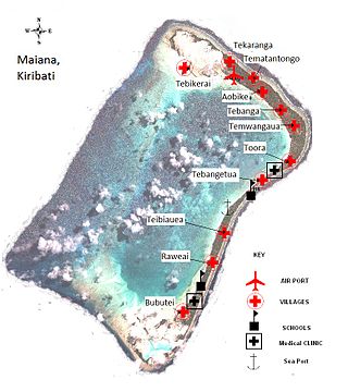
Maiana is an atoll in Kiribati and is one of the Central Gilbert Islands. Maiana is 44 kilometres (27 mi) south of the capital island of South Tarawa and has a population of 1,982 as of 2015. The northern and eastern sides of the atoll are a single island, whilst the western edge consists of submerged reefs and many uninhabited islets, all surrounding a lagoon. The atoll is 14 kilometres (8.7 mi) long and is very narrow, with an average width of less than 1 kilometre (0.62 mi) and a total land area of 16.72 square kilometres (6.46 sq mi).

<span class="mw-page-title-main">Marakei</span>

Marakei is a small atoll in the North Gilbert Islands. It consists of a central lagoon with numerous deep basins, surrounded by two large islands separated by two narrow channels. The atoll covers approximately 40 square kilometres (15 sq mi).

<span class="mw-page-title-main">Nonouti</span>

Nonouti is an atoll and district of Kiribati. The atoll is located in the Southern Gilbert Islands, 38 km north of Tabiteuea, and 250 km south of Tarawa. The atoll is the third largest in the Gilbert Islands and is the island where the Roman Catholic religion was first established in Kiribati, in 1888.

<span class="mw-page-title-main">Onotoa</span>

Onotoa is an atoll of Kiribati. It is situated in the Gilbert Islands in the Pacific Ocean, 65 km (40 mi) from Tamana, the smallest island in the Gilberts. The population of Onotoa in the 2015 census was 1,393.

<span class="mw-page-title-main">Makin (atoll)</span>

Makin is the name of an atoll, chain of islands, located in the Pacific Ocean island nation of Kiribati. Makin is the northernmost of the Gilbert Islands, with a population of 1,990.

<span class="mw-page-title-main">Buariki (Tarawa)</span>

Buariki is an island in northern Tarawa Atoll in the Gilbert Islands of the Republic of Kiribati. It was the site of the Battle of Buariki in World War II.

Tembinok', or Tem Binoka, was the Uea of Abemama, Aranuka and Kuria, in the Gilbert Islands, during the late 19th century.

Air Tungaru was the first airline of Kiribati. As the predecessor of current Air Kiribati, it was Kiribati's national flag carrier. Air Tungaru's main base was the international airport at Kiribati's capital, South Tarawa. From there, regular service was provided to all 16 domestic airports in the Gilbert Islands.

<span class="mw-page-title-main">North Tarawa</span> A string of islets in Kiribati governed by the Eutan Tarawa Council

North Tarawa or in Gilbertese Tarawa Ieta, in the Republic of Kiribati, is the string of islets from Buariki at the northern tip of Tarawa atoll to Buota in the South, with a combined population of 6,629 as of 2015. It is administratively separate from neighbouring South Tarawa, and is governed by the Eutan Tarawa Council (ETC), based at Abaokoro.

References

  1. 1 2 3 "9. Kuria" (PDF). Office of Te Beretitent - Republic of Kiribati Island Report Series. 2012. Retrieved 28 April 2015.
  2. 1 2 "Kiribati Census Report 2010 Volume 1" (PDF). National Statistics Office, Ministry of Finance and Economic Development, Government of Kiribati. Archived from the original (PDF) on 2013-09-30.
  3. 1 2 3 4 Dr Temakei Tebano & others (August 2008). "Island/atoll climate change profiles - Kuria Atoll". Office of Te Beretitent - Republic of Kiribati Island Report Series (for KAP II (Phase 2). Archived from the original on November 6, 2011. Retrieved 28 April 2015.
  4. Grimble, Arthur (1981). A Pattern of Islands. Penguin Travel Library. Penguin Books. ISBN   0-14-009517-9.
  5. Grimble, Arthur (1989). Tungaru traditions: writings on the atoll culture of the Gilbert Islands. Penguin Travel Library. University of Hawaii Press. ISBN   978-0-8248-1217-1.
  6. Samuel Eliot Morison (1944-05-22). "The Gilberts & Marshalls: A distinguished historian recalls the past of two recently captured pacific groups". Life magazine . Retrieved 2009-10-14.
  7. Stanton, William (1975). The Great United States Exploring Expedition . Berkeley: University of California Press. pp.  245. ISBN   0520025571.
  8. Cahoon, Ben. Kiribati. World Statesmen.org.
  9. Robert Louis Stevenson (1896). In the South Seas, Part V, Chapter 1. Chatto & Windus; republished by The Hogarth Press.
  10. 1 2 "Kuria factsheet" (PDF). Kiribati Tourism, Government of Kiribati.[ permanent dead link ]
  11. Premier Postal History. "Post Office List". Premier Postal Auctions. Retrieved 5 July 2013.