Filippo Reef

Last updated
Filippo Reef
KI Line islands.PNG
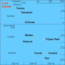
Filippo Reef and the Line Islands.
In-universe information
Type Phantom island

Filippo Reef is a reef that is asserted to be in the Pacific Ocean at 05°30′S151°50′W / 5.500°S 151.833°W / -5.500; -151.833 , 450 kilometres (280 mi) east of Starbuck Island in the Line Islands. The reef was reported by the master of the Italian barque Filippo as having been seen on 28 June 1886. From an unidentified report of breakers dated 1926, it was estimated to have a water depth of only 0.6 to 0.9 metres (2 to 3 ft), and appeared to be about 1.6 kilometres (1.0 mi) long northwest to southeast, and less in width. [1] [2]

The only sighting referenced shows a date of 1926. The topographic data supplied by the General Bathymetric Chart of the Oceans (GEBCO), however, shows a sea depth of 3.3 miles (5.3 km). [3] [4] It is therefore likely that this 1926 report is an error, and that Filippo Reef is a phantom island, and that therefore any maps showing it are relying on the 1926 report and are also in error.

Nevertheless, it is marked in the 2015 edition of the National Geographic Atlas of the World. [5]

See also

Related Research Articles

<span class="mw-page-title-main">Hydrography</span> Applied science of measurement and description of physical features of bodies of water

Hydrography is the branch of applied sciences which deals with the measurement and description of the physical features of oceans, seas, coastal areas, lakes and rivers, as well as with the prediction of their change over time, for the primary purpose of safety of navigation and in support of all other marine activities, including economic development, security and defense, scientific research, and environmental protection.

Piloting or pilotage is the process of navigating on water or in the air using fixed points of reference on the sea or on land, usually with reference to a nautical chart or aeronautical chart to obtain a fix of the position of the vessel or aircraft with respect to a desired course or location. Horizontal fixes of position from known reference points may be obtained by sight or by radar. Vertical position may be obtained by depth sounder to determine depth of the water body below a vessel or by altimeter to determine an aircraft's altitude, from which its distance above the ground can be deduced. Piloting a vessel is usually practiced close to shore or on inland waterways. Pilotage of an aircraft is practiced under visual meteorological conditions for flight.

<span class="mw-page-title-main">Bathymetric chart</span> Map depicting the submerged terrain of bodies of water

A bathymetric chart is a type of isarithmic map that depicts the submerged topography and physiographic features of ocean and sea bottoms. Their primary purpose is to provide detailed depth contours of ocean topography as well as provide the size, shape and distribution of underwater features. Topographic maps display elevation above ground and are complementary to bathymetric charts. Charts use a series of lines and points at equal intervals to showcase depth or elevation. A closed shape with increasingly smaller shapes inside of it can indicate an ocean trench or a seamount, or underwater mountain, depending on whether the depths increase or decrease going inward.

<span class="mw-page-title-main">Geography of the British Indian Ocean Territory</span>

The British Indian Ocean Territory (BIOT) is an archipelago of 55 islands in the Indian Ocean, located south of India. It is situated approximately halfway between Africa and Indonesia. The islands form a semicircular group with an open sea towards the east. The largest, Diego Garcia, is located at the southern extreme end. It measures 60 square kilometres (23 sq mi) and accounts for almost three-quarters of the total land area of the territory. Diego Garcia is the only inhabited island and is home to the joint UK-US naval support facility. Other islands within the archipelago include Danger Island, Three Brothers Islands, Nelson Island, and Peros Banhos, as well as the island groups of the Egmont Islands, Eagle Islands, and the Salomon Islands.

<span class="mw-page-title-main">Bass Islands (French Polynesia)</span> Archipelago in French Polynesia

The Bass Islands consist primarily of Rapa Iti and Marotiri. They are usually considered to be the southernmost of the Austral Islands, although this classification is more one of geographic and political expediency than because of similarities between them and the rest of the Austral Islands. The Bass Islands, lying several degrees outside the tropics, are the southernmost islands in French Polynesia. Culturally, the Bass Islands appear to have been colonized about the same time as Tahiti and the Marquesas, and the culture and language (Rapan) appear to have diverged about the same time as well, indicating that they developed in relative isolation almost from the time of first settlement.

<span class="mw-page-title-main">Duff Islands</span> Island group

The Duff Islands are a small island group lying to the northeast of the Santa Cruz Islands in the Solomon Islands province of Temotu. They are also sometimes known as the Wilson Islands.

The Sunda Trench, earlier known as and sometimes still indicated as the Java Trench, is an oceanic trench located in the Indian Ocean near Sumatra, formed where the Australian-Capricorn plates subduct under a part of the Eurasian Plate. It is 3,200 kilometres (2,000 mi) long with a maximum depth of 7,290 metres. Its maximum depth is the deepest point in the Indian Ocean. The trench stretches from the Lesser Sunda Islands past Java, around the southern coast of Sumatra on to the Andaman Islands, and forms the boundary between Indo-Australian Plate and Eurasian plate. The trench is considered to be part of the Pacific Ring of Fire as well as one of a ring of oceanic trenches around the northern edges of the Australian Plate.

Lyra Reef is a remote submerged coral atoll, about 40 kilometres (25 mi) in diameter, extending over an area of 1,300 square kilometres (500 sq mi). It lies about 200 kilometres (120 mi) north-east of New Ireland in the Bismarck Archipelago of Papua New Guinea, and 150 kilometres (93 mi) north-east of Simberi Island, the closest island, and about the same distance north-west of the Nuguria Islands.

<span class="mw-page-title-main">Lansdowne Bank</span>

Lansdowne Bank, sometimes called Landsdowne Bank, is an extensive submerged bank located between the main island of New Caledonia and the Chesterfield Islands, in the easternmost part of the Coral Sea. It covers an area of 4,300 km2 (1,660 sq mi), making it one of the largest banks of the world, has general depths of 60 to 80 metres (197–262 ft), and a largely sandy bottom. Two reefs mark the shallowest spots of the bank, but they are still submerged at low tide.

The General Bathymetric Chart of the Oceans (GEBCO) is a publicly available bathymetric chart of the world's oceans. The project was conceived with the aim of preparing a global series of charts showing the general shape of the seafloor. Over the years it has become a reference map of the bathymetry of the world’s oceans for scientists and others.

<span class="mw-page-title-main">Wachusett Reef</span> Apparent phantom reef in the South Pacific

Wachusett Reef was a phantom reef in the Antarctic Ocean.

<span class="mw-page-title-main">Chatham Sound</span>

Chatham Sound is a sound on the North Coast of British Columbia, Canada, bordering on Alaska, United States. It is located between the Dundas and Stephens Islands and the Tsimpsean Peninsula, it is part of the Inside Passage and extends from Portland Inlet in the north to Porcher Island in the south.

<span class="mw-page-title-main">Sirena Deep</span> Deep area in Mariana Trench

<span class="mw-page-title-main">Sandy Island, New Caledonia</span> Non-existent island near New Caledonia

Sandy Island is a non-existent island that was charted for over a century as being located near the French territory of New Caledonia between the Chesterfield Islands and Nereus Reef in the eastern Coral Sea. The island was included on many maps and nautical charts from as early as the late 19th century. It was removed from French hydrographic charts in 1974. The island gained wide media and public attention in November 2012 when the R/V Southern Surveyor, an Australian research ship, passed through the area and "undiscovered" it. The island was quickly removed from many maps and data sets, including those of the National Geographic Society and Google Maps.

<span class="mw-page-title-main">Tizard Bank</span>

The Tizard Bank, 10°15′N114°30′E is a partially sunken atoll and one of the significant maritime features of the north-western part of the Spratly Islands. It is claimed by the People's Republic of China, the Republic of China, and Vietnam, and various parts of it are occupied by these states.

<span class="mw-page-title-main">Null Island</span> Cartographical (only) marker at 0°N, 0°E

Null Island is the name of an imaginary place located at zero degrees latitude and zero degrees longitude, i.e., where the prime meridian and the equator intersect. The fictitious island, usually defined as 1 meter square, is often used in mapping software as a placeholder to help find and correct database entries that have erroneously been assigned the coordinates 0,0. Although Null Island started as a joke within the geospatial community, it has become a useful means of addressing a recurring issue in geographic information science.

The Zenith Plateau is a large bathymetric high in the Indian Ocean, located about 450 kilometres (280 mi) west-northwest of the Wallaby Plateau, 1,400 kilometres (870 mi) west-northwest of Carnarvon, Western Australia, and 1,700 kilometres (1,100 mi) north-west of Perth, Western Australia. The summit of the Zenith Plateau lies 1,960 meters (6,430 ft) below sea level and its base is at about 5,000 meters (16,000 ft) below sea level. It is about 300 kilometres (190 mi) long and 200 kilometres (120 mi) wide. In the east, the Zenith Plateau is separated from the Wallaby (Cuvier) Plateau by a 100–150 kilometres (62–93 mi) wide, north to northeast-trending bathymetric trough. The Zenith Plateau lies outside of the Australian Exclusive Economic Zone.

Vlinder Guyot is a guyot in the Western Pacific Ocean. It rises to a depth of 1,500 metres (4,900 ft) and has a flat top covering an area of 40 by 50 kilometres. On top of this flat top lie some volcanic cones, one of which rises to a depth of 551 metres (1,808 ft) below sea level. Vlinder Guyot has noticeable rift zones, including an older and lower volcano to the northwest and Oma Vlinder seamount south.

References

  1. Sailing Directions (Enroute), Pub. 126: Pacific Islands (PDF). Sailing Directions . United States National Geospatial-Intelligence Agency. 2017. p. 49.
  2. Sailing Directions for the Pacific Islands: Eastern groups. (1952). United States: U.S. Government Printing Office.
  3. General Bathymetric Chart of the Oceans (GEBCO)
  4. "Filippo Reef". WolframAlpha.com. Archived from the original on 30 June 2013. Retrieved 7 May 2013.
  5. National Geographic Atlas of the World (10th ed.). Washington, D.C.: National Geographic. 2015. p. plate 109. ISBN   978-1-4262-1354-0.