Contents

This is a list of notable reefs.
This is a list of notable reefs.
| Name | image | Location | Coordinates | Notes |
|---|---|---|---|---|
 | Red Sea to Madagascar | 0°03′05″S50°50′46″E / 0.051377°S 50.846055°E | ||
| Amazon Reef | | Off the coast of French Guiana and northern Brazil | 1°N49°W / 1°N 49°W | The Amazon Reef (also referred to as the Amazonian Reef) is an extensive coral and sponge reef system, located off the coast of French Guiana and northern Brazil. It is one of the largest reef systems in the world known to exist, with scientists estimating its length to be over 600 miles (970 km) long, and covering over 3,600 square miles (9,300 km2) of area. [1] |
| Angria Bank | | Off the coast of Vijaydurg, Maharashtra, India | 16°26′N72°02′E / 16.43°N 72.03°E | |
| Apo Reef | 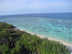 | Mindoro Strait, Philippines | 12°39′42″N120°24′52″E / 12.66167°N 120.4144°E | This is the Philippines' largest reef and the world's second-largest contiguous coral reef system. |
| Gulf Reef Mexico Arrecifes de Cozumel National Park | | Cozumel, Mexico | 20°10′25″N87°00′46″W / 20.1737°N 87.0129°W | Part of the Mesoamerican Barrier Reef System |
| Bar Reef | | Kalpitiya peninsula, Sri Lanka | 8°13′48″N79°26′24″E / 8.2300°N 79.4400°E | This coral reef has more biodiversity than in any of the waters of India. It is one of only a few pristine systems in Sri Lanka. |
| Belize Barrier Reef |  | Belize | 17°11′08″N87°19′26″W / 17.1856°N 87.324°W | This is the second biggest coral reef system on Earth, the largest being the Great Barrier Reef. It is approximately one-third the size of the 900 km (560 mi) long Mesoamerican Barrier Reef System. |
| Benares Shoals | 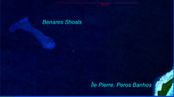 | Peros Banhos atoll, northern Chagos Archipelago | 5°09′S71°24′E / 5.15°S 071.40°E | |
| Blake Plateau reef |  | Southeastern United States | 31°N79°W / 31°N 79°W | |
| Bunaken National Marine Park | | North Sulawesi, Indonesia | 1°40′12″N124°45′00″E / 1.6700°N 124.7500°E | Bunaken National Park is renowned as one of the world's best diving and snorkeling destinations. Approximately 97% of the park's area consists of sea, with more than 390 types of coral reefs decorating its seabed. The coral reefs in Bunaken are formed as part of the Indo-Pacific coral reef ecosystem, and are known as one of the highest marine biodiversity in the world. |
| Coral Triangle |  | Mainly Indonesia | 3°58′13″N134°49′10″E / 3.970166°N 134.819424°E | Called the "Amazon of the seas", this is a large area defined within a triangular area in the waters of Indonesia, Malaysia, Papua New Guinea, Philippines, Solomon Islands and Timor-Leste. |
| Daintree Reef | | Coral Sea, Queensland, Australia | 16°01′58″S145°26′06″E / 16.032856°S 145.434958°E | Named after geologist and photographer Richard Daintree, this system is adjacent to the Daintree Rainforest. |
| Darwin Mounds | | Off the northwest coast of Scotland | 59°27′N7°08′W / 59.45°N 7.13°W | Located around 1,000 m (3,280 feet) below the surface, this system consists of a big field of sand mounds. |
| Filippo Reef | 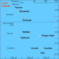 | 450 km east of Starbuck Island in the Pacific Ocean | 5°18′S151°30′W / 05.30°S 151.50°W | |
| Flinders Reef | | Off Moreton Island in the Coral Sea, Queensland, Australia | 26°59′18″S153°26′31.4″E / 26.98833°S 153.442056°E | |
| French Frigate Shoals | 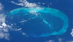 | Northwestern Hawaiian Islands | 23°26′44″N166°50′46″W / 23.4456°N 166.846°W | This is a 32-kilometre (20 mi; 17 nmi) long, crescent-shaped reef maintained by the United States Fish and Wildlife Service as a field station within the Papahānaumokuākea Marine National Monument. |
| Great Barrier Reef |  | Coral Sea, Queensland, Australia [2] | 18°10′16″S147°25′12″E / 18.1710°S 147.4200°E | The largest in the world |
| Isla Pérez | 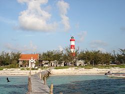 | Gulf of Mexico | 22°14′02″N89°25′12″W / 22.2340°N 89.4200°W | |
| Kingman Reef | 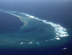 | North Pacific Ocean | 6°14′N162°15′W / 6.23°N 162.25°W | Roughly triangular in shape |
| Lansdowne Bank | 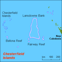 | Coral Sea | 20°21′S160°18′E / 20.35°S 160.30°E | This is one of the biggest banks on Earth. |
| Lyra Reef | | Papua New Guinea | 1°27′S153°12′E / 1.45°S 153.20°E | |
| Manuel Luis Reefs | | Brazil | 0°54′48″S44°19′10″W / 0.913302°S 44.319530°W | The largest coral reef of South America. [3] |
| Maro Reef | 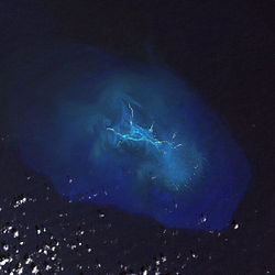 | Northwestern Hawaiian Islands | 25°24′54″N170°35′24″W / 25.415°N 170.590°W | This reef is named after the ship Maro, captained by Captain Joseph Allen who discovered the reef in 1820. |
| Mesoamerican Barrier Reef System | | From the Yucatán Peninsula to Honduras | 18°20′38″N87°25′18″W / 18.343938°N 87.421764°W | Also known as the Great Mayan Reef or Great Maya Reef, this is a World Heritage Site. |
| Mexico Rocks | | Ambergris Caye, Belize | 18°03′01″N87°33′19″W / 18.05021°N 87.555174°W | This area consists mainly of boulder corals and comprises about 100 Holocene patch reefs in a cluster on a ridge made of Pleistocene limestone. |
| Miami Terrace Reef |  | Florida, United States | 25°27′N79°33′W / 25.45°N 79.55°W | This is a deep reef system that lies at 200 to 600 metres (656 to 1,969 ft) below sea level. |
| Minami-Tori-shima | 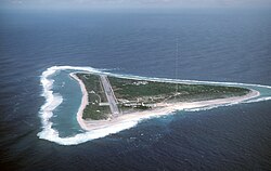 | Japan | 24°10′16″N153°35′06″E / 24.1712°N 153.5850°E | |
| Minerva Reefs |  | Fiji and Tonga | 23°23′S178°32′W / 23.38°S 178.54°W | |
| Miri-Sibuti Coral Reef National Park | | Sarawak, Malaysia | 4°11′N113°31′E / 4.19°N 113.51°E | This is a protected area and popular dive site. |
| Necker Island | | Northwestern Hawaiian Islands | 23°34′30″N164°42′01″W / 23.575°N 164.700278°W | Included within the Papahānaumokuākea Marine National Monument. The second-largest marine habitat in the Northwestern Hawaiian Islands, totaling 385,000 acres (156,000 ha). Lacks a fringing reef but has a shallow reef, beyond which extend deep-water coral shelves for many miles. Habitat includes 16 species of stony coral and is the easternmost place in the Hawaiian Islands where table corals of the genus Acropora are found. |
| New Caledonia Barrier Reef |  | New Caledonia | 20°14′39″S164°20′09″E / 20.2443°S 164.3359°E | This is a double-barrier coral reef, and the second-longest on Earth, the longest being the Belize Barrier Reef. |
| Ningaloo Coast | | Western Australia | 22°20′04″S113°29′01″E / 22.3345°S 113.4837°E | A World Heritage Site, this reef is noted for whale sharks. |
| North East Reef |  | Western Australia | 28°15′05″S113°29′03″E / 28.2513°S 113.4841°E | |
| Osprey Reef | | Coral Sea, Australia | 13°54′29″S146°36′55″E / 13.90806°S 146.61528°E | |
| Palancar Reef | | Cozumel, Mexico | 20°17′48″N87°01′06″W / 20.296685°N 87.018439°W | A popular diving location, this is part of the Arrecifes de Cozumel National Park. |
| Qixingyan (Taiwan) | | Pingtung County, Taiwan | 21°27′12″N120°29′34″E / 21.453198°N 120.492894°E | This is a shallow system with parts being visible at low tide. Many shipwrecks have occurred here. |
| Reunion Island's coral reef | 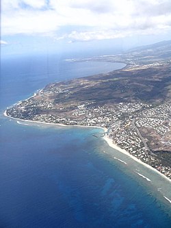 | Réunion | 21°05′06″S55°13′17″E / 21.0851°S 55.2214°E | Threatened in recent times by an increase in human exploitation as well as pollution |
| Røst Reef | | Lofoten, Norway | 67°29′02″N12°01′08″E / 67.483951°N 12.018849°E | This is the largest Lophelia reef known, and the biggest known deep-water coral reef system. |
| Scorpion Reef |  | Yucatán, Mexico | 22°13′33″N89°24′21″W / 22.2258°N 89.40578°W | This reef is part of the Campeche Bank archipelago. |
| Sha`b Abu Nuhas | | Northern Red Sea | 27°34′01″N33°55′01″E / 27.567°N 33.917°E | Considered a hazard to ships, this is a popular diving site. |
| South Sentinel Island | | Andaman Islands | 10°35′02″N92°07′54″E / 10.5840°N 92.1318°E | |
| Sula Reef | | Sør-Trøndelag, Norway | This reef is composed of Lophelia pertusa coral. | |
| Tubbataha Reef | | Sulu Sea, Philippines | 8°33′N119°33′E / 8.55°N 119.55°E | This reef system contains a very high density of different species and is designated a World Heritage Site. Tubbataha Reef is the world's richest and most pristine reef. |
| Villa Blanca Reef | | Cozumel, Mexico | 20°29′02″N86°58′30″W / 20.4839°N 86.9749°W | An unprotected reef located outside of the Arrecifes de Cozumel National Park. |
| Virgin Islands | | Caribbean Sea | 18°00′N65°00′W / 18.0°N 65.0°W | Scleractinian corals, Millepora. |
| Yabiji | | Ryukyu Islands | 25°00′00″N125°16′00″E / 25.0°N 125.266667°E | Reef group composed of about 300 kinds of corals. |
