
The Maldives are formed by 20 natural atolls, along with a few islands and isolated reefs today which form a pattern stretching from 7 degrees 10′ North to 0 degrees 45′ South. The largest of these atolls is Boduthiladhunmathi, while the atoll containing the most islands is Huvadhu.

The Chagos Archipelago or Chagos Islands is a group of seven atolls comprising more than 60 islands in the Indian Ocean about 500 kilometres (310 mi) south of the Maldives archipelago. This chain of islands is the southernmost archipelago of the Chagos–Laccadive Ridge, a long submarine mountain range in the Indian Ocean. In its north are the Salomon Islands, Nelson's Island and Peros Banhos; towards its south-west are the Three Brothers, Eagle, Egmont and Danger Island(s); southeast of these is Diego Garcia, by far the largest island. All are low-lying atolls, save for a few extremely small instances, set around lagoons.
Peros Banhos, Pedro dos Banhos or Baixos de Pêro dos Banhos in old maps, is a formerly inhabited atoll in the Chagos Archipelago of the British Indian Ocean Territory, also claimed by Mauritius.
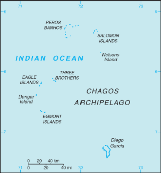
The British Indian Ocean Territory (BIOT) is an archipelago of 55 islands in the Indian Ocean, located south of India. It is situated approximately halfway between Africa and Indonesia. The islands form a semicircular group with an open sea towards the east. The largest, Diego Garcia, is located at the southern extreme end. It measures 60 square kilometres (23 sq mi) and accounts for almost three-quarters of the total land area of the territory. Diego Garcia is the only inhabited island and is home to the joint UK-US naval support facility. Other islands within the archipelago include Danger Island, Three Brothers Islands, Nelson Island, and Peros Banhos, as well as the island groups of the Egmont Islands, Eagle Islands, and the Salomon Islands.

The Salomon Islands or Salomon Atoll is a small atoll of the Chagos Archipelago, British Indian Ocean Territory.

The Three Brothers are a group of three small coral islands 20 kilometres east of Eagle Islands along the central western rim of the Great Chagos Bank, which is the world's largest coral atoll structure, located in the Chagos Archipelago.

Eagle Islands is a group of two islands in the Chagos Archipelago. They are located on the central-western rim of the Great Chagos Bank, which is the world's largest coral atoll structure.

Egmont Islands is an uninhabited atoll administered by the United Kingdom. They are one of the few emerged coral atolls that make up the Chagos Archipelago, British Indian Ocean Territory.
Blenheim Reef is a partly submerged atoll structure in the Chagos Archipelago, Indian Ocean. It includes the coral reef of Baxio Predassa in its southeastern rim, plus another completely submerged part. It is located in the northeastern part of the Chagos Archipelago. It measures almost eleven kilometres (north–south) by more than four kilometres (east–west), with a total area of 36.8 square kilometres, including the lagoon of 8.5 km², the difference being accounted for the mostly by the reef flat. Only on the eastern side, there are a few sand cays above the water. The largest of them is East Island, which is not quite 200 metres long and 70 metres wide. The other islands in the group are North, Middle and South. Only a few grasses grow on the island. The lagoon is up to 18 metres deep and encumbered with rock. The fringing coral reef has a wide passage in the southwest. The closest land is Takamaka Island in the Salomon Islands Atoll, about 20 kilometres to the southwest.
Cauvin Bank is a wholly submerged atoll structure in the southern part of the Chagos Archipelago at 6°49′S72°22′E, just about 7 km (4 mi) south of the southeastern corner of the rim of the Great Chagos Bank. It is roughly circular in shape, with a diameter of 4 km (2 mi), and an area of about 12 km2 (5 sq mi). There are least depths between 9 and 11 m in the northern part of the reef. The closest land is the northernmost part of Diego Garcia atoll, Middle Island, 41 km (25 mi) to the south.
Wight Bank is a small, wholly submerged atoll structure in the Southwest of the Chagos Archipelago, Indian Ocean. It is located 6 kilometres to the SE off the southeastern tip of Pitt Bank at 7°25′S71°32′E. It is less than 2 km in diameter, and its total area is about 3 square kilometres. The closest piece of land is Île Sudest of Egmont Atoll, at 80 km (50 mi) NNW. Diego Garcia is 94 km (58 mi) to the east. The least charted depth is 8.5 km (5.3 mi).

Scott and Seringapatam Reefs is a group of atoll-like reefs in the Timor Sea more than 300 kilometres (190 mi) northwest of Cape Leveque, Western Australia, on the edge of the continental shelf. There are three or four separate reef structures, depending on whether Scott Reef Central is counted separately.
The Muirfield Seamount is a submarine mountain located in the Indian Ocean approximately 130 kilometres southwest of the Cocos (Keeling) Islands. The Cocos Islands are an Australian territory, and therefore the Muirfield Seamount is within Australia's Exclusive Economic Zone (EEZ). The Muirfield Seamount is a submerged archipelago, approximately 2.5 kilometres in diameter and 16–18 metres below the surface of the sea. A 1999 biological survey of the seamount performed by the Australian Commonwealth Scientific and Industrial Research Organisation (CSIRO) revealed that the area is depauperate.
Robert Moresby was a captain of the East India Company's Bombay Marine/Indian Navy who distinguished himself as a hydrographer, maritime surveyor and draughtsman.

The Tizard Bank, 10°15′N114°30′E is a partially sunken atoll and one of the significant maritime features of the north-western part of the Spratly Islands. It is claimed by Vietnam, China, and Taiwan, and various parts of it are occupied by these states.


