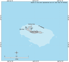
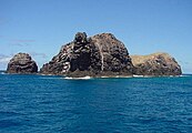
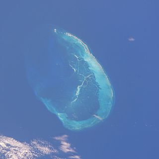
The remnant of a volcanic cone,[6] Necker Island is located about 120 kilometers (65nmi; 75mi) southeast of the French Frigate Shoals[7] on the northwestern end of a large, shallow ocean bank.[8] It is a hook-shaped rocky ridge about 1.3 kilometers (0.8mi) long and between 60 and 200 meters (197 and 656ft) wide.[9][7] Composed of basalt,[10] the island is steep-sided and barren, with very little soil,[3] and its rocks are heavily scoured and eroded.[11] It is the second-smallest of the Northwestern Hawaiian Islands,[11] with a total area of 45.193 acres (18.289ha) according to the United States Census Bureau[4] or 41 acres (17ha)[9] or 39.5 acres (16ha) according to the United States Fish and Wildlife Service.[11]
The westernmost point on Necker Island is Mo'o Point (or Mo'o Head). The island's "hook" is Northwest Cape, a narrow spur that reaches a maximum height of 48 meters (156ft) and juts northeastward from the west end of the island for 183 meters (600ft).[12] Northwest Cape is connected to the rest of the island by a narrow gap that is barely above sea level.[7] Northwest Cape's tip is the northernmost point of the island.[12]
The main ridge of the island and Northwest Cape combine to partially enclose Shark Bay along the northern shore of the island; the bay opens to the northeast and usually is subject to rough seas.[9] Along the island's western shore, West Cove lies between Mo'o Point and the southern end of Northwest Cape.[12] A small islet, 300 feet (91m) long and rising 10 feet (3m) above sea level, lies just off Necker Island's eastern tip.[9]
The main ridge of Necker Island has five peaks. East to west, they are:[9]
Siever's Peak, 61 meters (200ft) high
Bowl Hill (or Bryan Peak), 79 meters (259ft) high
Summit Hill (or Vaughn Peak), 84 meters (277ft) high, the island's highest point
Flagpole Hill, 56.4 meters (185ft) high
Annexation Peak (also Annexation Hill or Captain Brown Peak), 75 meters (247ft) high
Bowl Cave is located on the northern slope of Bowl Hill. It is an important archaeological site.[13]
Necker Island has an average annual rainfall of just under 25 inches (635mm).[3]
Flora and fauna
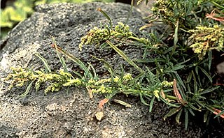
Vegetation on Necker Island is limited to low shrubs and grasses, none more than 2 feet (0.6m) tall.[9] Five species of plants are known to occur:[9]
Bunch grass (Panicum torridum) (i.e., kakonakona), which grows on the north slope of the ridge
Purslane (Portulaca lutea) (i.e., ihi weed), found on flat tops of the ridge
Pickle weed (Sesuvium portulacastrum), a patch of which grows on the lower northeastern slope of Annexation Hill, where ocean spray from waves breaking in Shark Bay can reach it
The forester of the Territory of Hawaii attempted to introduce six other species of plants to Necker Island in June 1923, but all had died out by the latter half of the 1930s, if not earlier.[9]
The island is also noted for large numbers of birds.[9] About 16 species of seabird nest on Necker Island;[14] during nesting season, an estimated 60,000 birds nest on the island, and their eggs cover virtually every piece of level ground.[9][14] A seabird first observed at Necker Island and at the French Frigate Shoals and Nihoa in 1902 originally was thought to be new to science and was given the scientific nameProcelsterna saxatalis and the popular name "Necker Island tern," but it later was identified as a subspecies of the blue-grey noddy, already known from farther south in the Pacific.[15][16] No land birds live on the island.[7] Land animals found on the island include land snails and 15 species of insect found nowhere else, as well as wolf spiders and bird ticks.[11]
Although it is the second-smallest of the Northwestern Hawaiian Islands, Necker Island has the second-largest surrounding marine habitat among the islands, totaling 385,000 acres (156,000ha), with Shark Bay, West Cove, Northwest Cape, and miles of shallow reef to the southeast of the island providing large offshore habitats.[10][11] Runoff from the heavily eroded rock surfaces of the island and the constant wave action that scours its underwater basalt structure interfere with the growth of corals; little coral life exists in the shallow areas surrounding the island,[11] and it lacks a fringing reef.[7] However, 16 species of stony coral live in the area, and Necker is the easternmost island in the Hawaiian archipelago where table corals of the genusAcropora are found.[10]Gray reef sharks and manta rays are common off the island, and Hawaiian monk seals populate its shores, some giving birth to pups there.[10][11][7]Green sea turtles bask on the shore in the narrow gap between the main island and Northwest Cape, but they do not breed on Necker Island because the island lacks sandy beaches in which they could lay their eggs.[7] A great abundance and diversity of sea cucumbers, sea urchins, and lobsters live in Shark Bay.[11] Extensive deeper "shelves" extend many miles from the island's shallow reef, especially to the southeast, and commercial fishing takes place over these shelves,[11] which produce much of Hawaii's catch of green jobfish, known locally as gray snapper or uku.[10]Deep sea fish types that live hundreds of meters (yards) below the surface along the underwater slopes of Necker Island include fishes of the ordersStomiiformes, Gadiformes, Myctophiformes, and Aulopiformes.[17]
Archaeology
Standing stones of Necker Island
Necker Island is known for its numerous religious sites and cultural objects.[10] There are few, if any, signs of long-term habitation, giving rise to the theory that people visited the island for short periods from other islands instead of settling permanently.[11] Many anthropologists believe that the island was a ceremonial and religious site. Necker has 55 currently known sites including 33 ritual sites called heiau, while the remaining sites represent agricultural terraces, miscellaneous platforms, and shelter caves — of which Bowl Cave is the largest.[11] Cultural sites on Necker Island are contemporaneous with those on Nihoa and appear to have been abandoned at roughly the same time several centuries prior to European contact with the Hawaiian Islands.[18][19]
The heiau on Necker Island and Nihoa are unique in the Hawaiian chain representing a raised pavement of basalt stones with upright stones placed across this pavement often near the edges as opposed to the form common to other islands in the chain represented by a high stacked stone wall enclosing a central space.[18] This difference in form represents an earlier iteration of Hawaiian monumental architecture that offers a unique perspective on cultural norms prior to the abandonment of Necker.[19] Thanks to this difference in form, scholars often use the term 'marae' as opposed to 'heiau' in reference to these structures and some scholars argue that the shift in form represents a shift in ritual practice in Hawaii.[20]
Artifacts excavated on Necker Island show a remarkable number of items that would normally be made out of wood rendered in stone. This is especially true of the presence of a series of remarkable carved stone bowls and a bird snare that would have required far more time and effort to create from stone. Additionally, a series of human figures carved from local stone have been recovered from Necker. These statues are up to 1.5 feet (0.5 m) in length and differ in style and medium to similar sculptures (usually rendered in wood) recovered elsewhere in Hawaii.[18] Other artifacts include adzes, fish and squid lures, hammer stones, awls, and other stone tools commonly found across the Hawaiian Islands.[21]
According to the oral traditions of the people of Kauai, which lies to the southeast, Necker Island was the last known refuge for a race of mythical "little people" called the Menehune. According to the legend, the Menehune settled on Necker Island after being chased off Kauai by the stronger Polynesians and subsequently built the various stone structures there. [citation needed]
History
Geological research in the early 21st century indicates that Necker Island is about 10 million years old.[22] While it rises only about 84 meters (277ft) above sea level now, it reached 1,000 meters (3,281ft) in height earlier in its history and at one time was comparable in size to modern Oahu.[23][24]
Hawaiians appear to have started visiting Necker Island a few hundred years after they settled the main Hawaiian Islands. Archaeologists believe that the island's poor soil for farming and its small size and relative lack of rainfall made it uninhabitable, and that the Hawaiians visited from Nihoa and other nearby islands to worship at religious sites without establishing any permanent settlements.[11] Their visits appear to have ended a few hundred years before European contact, and by the time Europeans first visited Hawaii in the late eighteenth century, Necker Island apparently was unknown to the Hawaiians.[25]
The French explorer Jean-François de La Pérouse was on a mission of exploration for the French Academy of Sciences aboard the ships L'Astrolabe (under command of Fleuriot de Langle) and La Boussole[26] and had just discovered the French Frigate Shoals (Basse des Frégates Françaises) and his namesake rock La Perouse Pinnacle[24][20] when on November 4, 1786, he became the first European to visit Necker Island.[25][11] La Pérouse did not attempt to land on the island due to its nearly vertical sides and the violent seas breaking on its shore, but he sailed within a third of a league of it and named it after Jacques Necker, a Genevan banker and statesman who served as finance minister for Louis XVI of France.[10][11][24] Although the expedition was lost at sea in 1788, it was able to send its logs home before its loss, bringing the island's existence to the attention of Europeans.[24] The first people to set foot on Necker Island in modern times appear to have been the British seaman John Turnbull of the ship Margaret, who visited the Hawaiian Islands between December 17, 1802, and January 21, 1803, and two Hawaiian pearl divers in his employ; the three men landed on the island during an expedition to find pearls on a reef in the Northwestern Hawaiian Islands.[25]
Captain John[25] or William[24] Paty (sources disagree on Paty's first name) claimed Necker Island for the Kingdom of Hawaii in 1857, although he did not land on the island.[11][24] The claim was disputed over the following decades.[11] In January 1859, United States NavyLieutenant J. M. Brook aboard the surveyschoonerUSSFenimore Cooper visited Necker Island and determined its position.[25] During the summer of 1859, Captain N. C. Brook of the Hawaiian barqueGambia passed the island during a sealing and exploration voyage, but did not report landing on it.[25]
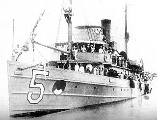
As late as the early 1890s, the Kingdom of Hawaii's claim to Necker Island remained in dispute, and the United Kingdom was considering the island as a potential waypoint location for a submarine communications cable between Canada and Australia[27] as part of the British Empiretelegraph network known informally as the All Red Line. The Kingdom of Hawaii was overthrown in 1893 and replaced by the Provisional Government of Hawaii, and when the British corvetteHMSChampion arrived at Honolulu in 1894, the provisional government's president, Sanford B. Dole, became concerned that the United Kingdom was about to establish a claim to Necker Island. Wishing to curry favor with the United States rather than the United Kingdom, Dole immediately dispatched an expedition under Captain James A. King to Necker to annex the island. On May 27, 1894, a landing party of 12 men led by King went ashore on Necker for four hours, raised the flag of Hawaii on what became known as Annexation Hill, and read an annexation proclamation.[11][28] The move brought international disputes over claims to the island to an end and the island was included in the Republic of Hawaii when it was founded on July 4, 1894, although the British government continued to attempt to negotiate with the Hawaiian government over use of Necker Island and on September 24, 1894, Champion landed a party on the island.[24][5] On July 12, 1895, King led a Hawaiian government expedition — which also included the first director of the Bishop Museum, William Tufts Brigham, and Professor William DeWitt Alexander — to Necker to survey and map the island and conduct archaeological research.[5] On August 12, 1898, the United States annexed the Hawaiian Islands, including Necker Island, and Necker was included in the Territory of Hawaii upon its creation on April 30, 1900.
In 1902, the United States Fish Commissionresearch shipUSFC Albatross visited Necker Island, and her personnel thought they discovered the "Necker Island tern" there, as well as on Nihoa and at the French Frigate Shoals, during their visit, although the bird later was determined to be a subspecies of the blue-grey noddy, already known from farther south in the Pacific.[15][16] The island was leased for commercial fishing purposes for 21 years on June 2, 1904, and on February 3, 1909, it became part of the Hawaiian Islands Bird Reservation, managed jointly by the United States Department of Agriculture and the Territory of Hawaii.[5]
Access to Necker Island is by boat, and is quite difficult because of the island's nearly vertical coastline.[9] Heavy surf usually precludes landings along the coast in Shark Bay, but a small lee exists west of Northwest Cape, and landing on rocky shelves there is possible in moderately calm weather[9] but can be dangerous in high surf.[7]
Visits to Necker Island are permitted only for scientific, educational, and cultural purposes and require the approval of the United States Fish and Wildlife Service, which gives preference to scientific and cultural visits.[10][11]
Midway Atoll is a 2.4 sq mi (6.2 km2) atoll in the North Pacific Ocean. Midway Atoll is an insular area of the United States and is an unorganized and unincorporated territory. The largest island is Sand Island, which has housing and an airstrip. Immediately east of Sand Island, across the narrow Brooks Channel, is Eastern Island, which is uninhabited and no longer has any facilities. Forming a rough, incomplete circle around the two main islands and creating Midway Lagoon is Spit Island, a narrow reef.
Kure Atoll or Ocean Island is an atoll in the Pacific Ocean 48 nautical miles west-northwest of Midway Atoll in the Northwestern Hawaiian Islands at 28°25′N178°20′W. A coral ring 6 miles (9.7 km) across encloses a lagoon several meters deep. The atoll's largest island is called Green Island, and is a habitat for hundreds of thousands of seabirds in present day and wildlife staff. A short, unused and unmaintained runway and a portion of one building, both from a former United States Coast Guard LORAN station, are located on the island. Politically, it is part of Hawaii, though nearest island is Midway, which is a separate unorganized territory. Kure Atoll, in addition to being the nesting grounds for tens of thousands of seabirds, has recorded several vagrant terrestrial birds, including snow bunting, eyebrowed thrush, brambling, olive-backed pipit, black kite, Steller's sea eagle and Chinese sparrowhawk. It is currently managed as a Wildlife Bird Sanctuary by the State of Hawaii's Department of Land and Natural Resource–Division of Forestry and Wildlife as one of the co-trustees of Papahānaumokuākea Marine National Monument with support from the Kure Atoll Conservancy. Kure is one of the most westernmost islands of the Northwestern Hawaiian Islands.
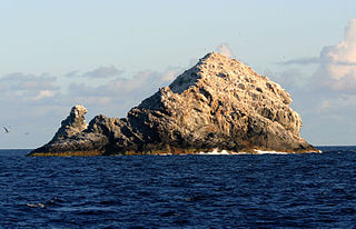
The Gardner Pinnacles are two barren rock outcrops surrounded by a reef and located in the Northwestern Hawaiian Islands.
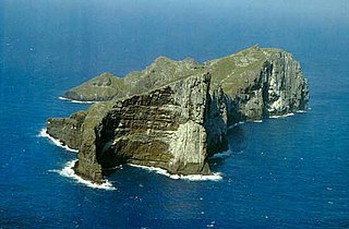
Nihoa, also known as Bird Island or Moku Manu, is the tallest of ten islands and atolls in the uninhabited Northwestern Hawaiian Islands (NWHI). The island is located at the southern end of the NWHI chain, 296 km (160 nmi) southeast of Necker Island. Nihoa is the closest NWHI in proximity to the eight main windward Hawaiian Islands at approximately 240 km (130 nmi) northwest of the island of Kauaʻi. The island has two peaks, 272 m (892 ft) Miller's Peak in the west, and 259 m (850 ft) Tanager Peak in the east. Nihoa's area is about 171 acres (0.69 km2) and is surrounded by a 142,000-acre (57,000 ha) coral reef. Its jagged outline gives the island its name, Nīhoa, which is Hawaiian for "toothed, serrated".
The French Frigate Shoals is the largest atoll in the Northwestern Hawaiian Islands. Its name commemorates French explorer Jean-François de Galaup, comte de Lapérouse, who nearly lost two frigates when attempting to navigate the shoals. It consists of a 20-mile-long (32 km) crescent-shaped reef, twelve sandbars, and the 120-foot-high (37 m) La Perouse Pinnacle, the only remnant of its volcanic origins. The total land area of the islets is 61.508 acres (24.891 ha), while the total coral reef area of the shoals is over 232,000 acres (94,000 ha). Tern Island, with an area of 26.014 acres (10.527 ha), has a landing strip and permanent habitations for a small number of people. It is maintained as a field station in the Hawaiian Islands National Wildlife Refuge by the United States Fish and Wildlife Service. The French Frigate Shoals are about 487 nautical miles northwest of Honolulu. Among the shoals are Tern, which is unique in having an airstrip and is protected by a seawall, and La Perouse Pinnacle, a tall and rocky island in the center of the shoals. The two largest islands after Tern, East and Trig, have mostly washed away, with East being about half the size from storms, but are famed as breeding grounds for turtles. East was also home to Coast Guard base in the late 20th century. The islands are surrounded by a coral reef, and the islands themselves are noted breeding ground for turtles, seals, and birds. Habitation is difficult with little vegetation and no fresh water. The French Frigate Shoals are also called Lalo as part of the marine nature reserve, and along with other islands are visited periodically for research. The highest point in the shoals is on La Perouse Pinnacle, which is a volcanic rock that rises 122 ft (37 m) above the surrounding lagoon.
The Northwestern Hawaiian Islands also known as the Leeward Hawaiian Islands, are a series of islands and atolls located northwest of Kauai and Niʻihau in the Hawaiian island chain. Politically, these islands are part of Honolulu County in the U.S. state of Hawaii, with the exception of Midway Atoll. Midway Atoll is a territory distinct from the State of Hawaii, and is classified as one of the United States Minor Outlying Islands. The United States Census Bureau designates this area, excluding Midway Atoll, as Census Tract 114.98 of Honolulu County. The total land area of these islands is 3.1075 square miles. With the exception of Nihoa, all these islands lie north of the Tropic of Cancer, making them the only islands in Hawaii situated outside the tropics.
The Pearl and Hermes Atoll, also known as Pearl and Hermes Reef, is part of the Northwestern Hawaiian Islands, a group of small islands and atolls that form the farthest northwest portion of the Hawaiian island chain. The atoll consists of a variable number of flat and sandy islets, typically between five and seven. More were noted in historical sources but have since been lost to erosion and rising sea levels.
Laysan is one of the Northwestern Hawaiian Islands, located 808 nautical miles northwest of Honolulu. It has one land mass of 1,016 acres (411 ha), about 1 by 1+1⁄2 miles in size. It is an atoll of sorts, although the land completely surrounds Laysan Lake, some 2.4 m (7.9 ft) above sea level, that has a salinity approximately three times greater than the ocean. Laysan's Hawaiian name, Kauō, means "egg".
Lisianski Island is one of the Northwestern Hawaiian Islands, with a land area of 384.425 acres (155.571 ha) and a maximum elevation of 40 feet (12 m) above sea level. It is a low, flat sand and coral island about 905 nautical miles northwest of Honolulu, Hawaii. The island is surrounded by reefs and shoals, including the extensive Neva Shoals. Access to the island is possible only by helicopter or by boat via a narrow sandy inlet on the southeastern side of the island.
Pritchardia remota, the Nihoa pritchardia, Nihoa fan palm, or Loulu, is a species of palm endemic on the island of Nihoa, Hawaiʻi, and later transplanted to the island of Laysan. It is a smaller tree than most other species of Pritchardia, typically reaching only 4–5 metres (13–16 ft) tall and with a trunk diameter of 15 centimetres (5.9 in). It is the only type of tree on the island and used to be abundant. In 1885 a wildfire ravaged the island, destroying most of the palms. Only about 700 of these trees remain, making the species endangered but numbers are slowly increasing. The palm is being cultivated in botanical gardens.
The Papahānaumokuākea Marine National Monument (PMNM) is a World Heritage listed U.S. national monument encompassing 583,000 square miles (1,510,000 km2) of ocean waters, including ten islands and atolls of the Northwestern Hawaiian Islands. It was created in June 2006 with 140,000 square miles (360,000 km2) and expanded in August 2016 by moving its border to the limit of the exclusive economic zone, making it one of the world's largest protected areas. It is internationally known for its cultural and natural values as follows:
The area has deep cosmological and traditional significance for living Native Hawaiian culture, as an ancestral environment, as an embodiment of the Hawaiian concept of kinship between people and the natural world, and as the place where it is believed that life originates and to where the spirits return after death. On two of the islands, Nihoa and Mokumanamana, there are archaeological remains relating to pre-European settlement and use. Much of the monument is made up of pelagic and deepwater habitats, with notable features such as seamounts and submerged banks, extensive coral reefs and lagoons.
Amaranthus brownii was an annual herb in the family Amaranthaceae. The plant was found only on the small island of Nihoa in the Northwestern Hawaiian Islands, growing on rocky outcrops at altitudes of 120–215 m (394–705 ft). It was one of nine species of Amaranthus in the Hawaiian Islands, as well as the only endemic Hawaiian species of the genus. It is now considered extinct.
The Nihoa conehead katydid is a species of katydid which is endemic to the Hawaiian island of Nihoa. It is one of the ten species in the genus Banza, all of them native to Hawaii, although it is the sister species to the remaining nine, and may belong in a separate genus. It gets its food mostly from plant leaves, but because of the low population, it does not do significant damage. Unlike Main Islands' species, whose males leap on the females before mating, the Nihoa variants sing to them. It is listed as a vulnerable species on the IUCN Red List, and as a "species of concern" under the Endangered Species Act.
Thaumatogryllus conanti is a nocturnal species of cricket endemic to the island of Nihoa, where it is found in Devil's Slide, a narrow ravine. It is named after Sheila Conant, the scientist who discovered it in the 1980s. Including T. conanti, there are only four known species in the genus Thaumatogryllus, which is endemic to Hawaii. Another species is found only in lava tubes on the Island of Hawaii.
The TanagerExpedition was a series of five biological surveys of the Northwestern Hawaiian Islands conducted in partnership between the Bureau of Biological Survey and the Bishop Museum, with the assistance of the United States Navy. Four expeditions occurred from April to August 1923, and a fifth in July 1924. Led by Lieutenant Commander Samuel Wilder King on the minesweeper USS Tanager (AM-5), and Alexander Wetmore directing the team of scientists, the expedition studied the plant animal life, and geology of the central Pacific islands. Noted members of the team include archaeologist Kenneth Emory and herpetologist Chapman Grant.
Tern Island is a coral island located near French Frigate Shoals in the Northwestern Hawaiian Islands. It is in the Hawaiian Islands National Wildlife Refuge. It is approximately 490 miles west-northwest of Oahu, about halfway to Midway Island to the west.
La Perouse Pinnacle is a steep basalt outcrop at French Frigate Shoals in the Pacific Ocean. Rising approximately 122 ft (37 m) above sea surface, it is the eroded plug of a shield volcano and caldera that formed 12million years ago. The rocky formation lies within the Papahānaumokuākea Marine National Monument. Because of its prominence and shape, the pinnacle can be mistaken for a sailing ship from a distance.
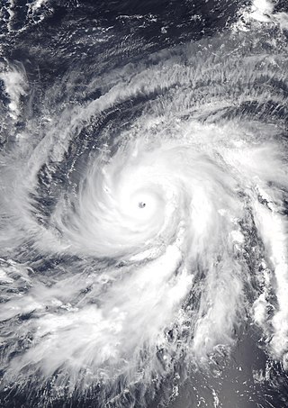
Hurricane Walaka was a strong tropical cyclone that brought high surf and a powerful storm surge to the Northwestern Hawaiian Islands. Walaka was the nineteenth named storm, twelfth hurricane, eighth major hurricane, and second Category 5 hurricane of the 2018 Pacific hurricane season.
East Island is an island, formerly about 11 acres (45,000 m2) in area, one-half mile (800 m) long and 400 feet (120 m) wide, now greatly reduced in size. It was the second-largest in the French Frigate Shoals, and is one of the Northwestern Hawaiian Islands, approximately 550 miles (890 km) northwest of Honolulu. It was largely washed away in 2018 by the storm surge from Hurricane Walaka. The remaining portion of the island above sea level consists of a sandy strip approximately 150 feet (46 m) long.
The Northwestern Hawaii scrub is a tropical and subtropical grasslands, savannas, and shrublands ecoregion on the Northwestern Hawaiian Islands in the Pacific Ocean.
↑ https://www.ncbi.nlm.nih.gov/books/NBK208869 National Academy of Sciences. (2004). Evolution in Hawaii: A Supplement to Teaching About Evolution and the Nature of Science, by Steve Olson. Washington, DC: The National Academies Press, 2004.
Evenhuis, Neal L.; Eldredge, Lucius G., eds. (2004). Natural History of Nihoa and Necker Islands. Bishop Museum Bulletin in Cultural and Environmental Studies; No. 1. Honolulu, Hawaii: Bishop Museum Press. ISBN1-58178-029-X.
"Necker Island". The Columbia Gazetteer of North America. Columbia University Press. 2000. Archived from the original on March 29, 2002.
External links
Wikimedia Commons has media related to Necker Island.
This page is based on this Wikipedia article Text is available under the CC BY-SA 4.0 license; additional terms may apply. Images, videos and audio are available under their respective licenses.