
Honolulu is the capital and most populous city of the U.S. state of Hawaii, which is in the Pacific Ocean. An unincorporated city, it is the county seat of the consolidated City and County of Honolulu, situated along the southeast coast of the island of Oʻahu, and is the westernmost and southernmost major U.S. city. Honolulu is Hawaii's main gateway to the world. It is also a major hub for business, finance, hospitality, and military defense in both the state and Oceania. The city is characterized by a mix of various Asian, Western, and Pacific cultures, reflected in its diverse demography, cuisine, and traditions.

Interstate H-3 (H-3) is an Interstate Highway located entirely within the US state of Hawaii on the island of Oʻahu. H-3 is also known as the John A. Burns Freeway, after the second governor of Hawaii. It crosses the Koʻolau Range along several viaducts and through the 5,165-foot-long (1,574 m) Tetsuo Harano Tunnels as well as the much smaller Hospital Rock Tunnels.

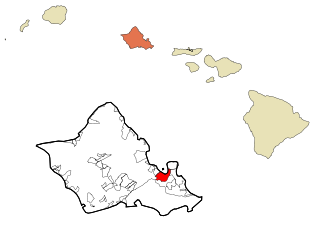
Halawa is a census-designated place (CDP) in the ‘Ewa District of Honolulu County, Hawaii, United States. Halawa Stream branches into two valleys: North and South Halawa; North Halawa is the larger stream and fluvial feature. Their confluence is within the H-3/H-201 highways exchange. Most of Halawa Valley is undeveloped. As of the 2020 census, the CDP had a population of 15,016.
Kaneohe or Kāneʻohe is a census-designated place (CDP) included in the City and County of Honolulu and in Hawaiʻi state District of Koʻolaupoko on the island of Oʻahu. In the Hawaiian language, kāne ʻohe means "bamboo man". According to an ancient Hawaiian story, a local woman compared her husband's cruelty to the sharp edge of cutting bamboo; thus the place was named Kāneʻohe or "bamboo man".
The following is an alphabetical list of articles related to the U.S. state of Hawaii:

John Henry Wilson, was a civil engineer, insurgent, co-founder of the Democratic Party of Hawaii, and Mayor of Honolulu, Hawaii three times: from 1920 to 1927, from 1929 to 1931, and from 1946 to 1954.
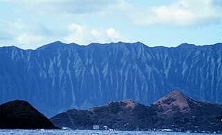
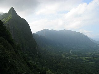
Koʻolau Range is a name given to the dormant fragmented remnant of the eastern or windward shield volcano of the Hawaiian island of Oʻahu. It was designated a National Natural Landmark in 1972.
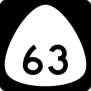
Route 63 is a state highway on the island of Oʻahu in Honolulu County, Hawaiʻi, United States, that is one of three main highways passing through the Koʻolau mountain.

Nuʻuanu Pali is a section of the windward cliff of the Koʻolau mountain located at the head of Nuʻuanu Valley on the island of Oʻahu. It has a panoramic view of the windward (northeast) coast of Oʻahu. The Pali Highway connecting Kailua/Kāneʻohe with downtown Honolulu runs through the Nuʻuanu Pali Tunnels bored into the cliffside.

Hawaii Route 61, often called the Pali Highway, is in Honolulu County, Hawaii, United States, that is the main highway connecting downtown Honolulu with the windward side of Oʻahu island. From downtown, it traverses up Nuʻuanu Valley and the residential neighborhood of Nuʻuanu, passes through the Nuʻuanu Pali Tunnels, and descends to the major windward communities of Kāneʻohe and Kailua.
The John H. Wilson Tunnels are a pair of highway tunnels passing through the Ko‘olau Range on the island of O‘ahu. The tunnels are located on Likelike Highway, which connects Kāneʻohe with Honolulu, and are 2775 feet long westbound and 2813 feet long eastbound, at 21°24′08.0″N157°48′54.4″W.
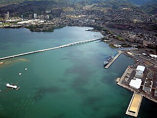
Admiral Clarey Bridge, also known as the Ford Island Bridge, is a 4,672 ft (1,424 m) road bridge that connects Ford Island in Pearl Harbor to the mainland of Oahu, the third-largest island of Hawaii. A 930 ft (280 m) section of it is supported by pontoons, and can be moved to allow vessels to pass through. This floating moveable span is the largest in the world.

The Hawaiian Organic Act, Pub. L.Tooltip Public Law 56–339, 31 Stat. 141, enacted April 30, 1900, was an organic act enacted by the United States Congress to establish the Territory of Hawaii and to provide a Constitution and government for the territory. The Act was replaced by the Hawaii Admission Act on August 21, 1959, when the territory was admitted to the Union as the State of Hawaii.
The Nuʻuanu Pali Tunnels are a set of four highway tunnels on the Pali Highway which pass through the Nuʻuanu Pali in Hawaii, United States. These tunnels serve as one of three trans-Koʻolau routes between Honolulu and the communities of windward Oʻahu. Also, the Nuuanu Pali Tunnels serve as a major transportation route from Kaneohe and Kailua over to Honolulu. These tunnels and the Pali Highway were built to provide a safer route through the mountain ridge, replacing a narrow, winding, and dangerous road over the mountain.

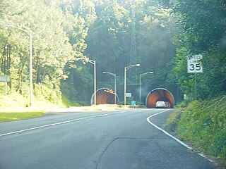
The Tetsuo Harano Tunnels are a pair of highway tunnels passing through the Ko‘olau Range on the island of O‘ahu. The tunnels are located on Interstate H-3, which connects Kaneohe with Interstate H-1 at Hālawa near Pearl Harbor, and are 4,980 feet (1,520 m) long Kaneohe-bound and 5,165 feet (1,574 m) long Halawa-bound.
The Hospital Rock Tunnels are a small pair of highway tunnels passing through a ridge on the edge of the Ko‘olau Range on the island of O‘ahu, Hawaiʻi, USA. The tunnels are located on Interstate H-3, which connects Kaneohe with Interstate H-1 at Hālawa near Pearl Harbor, and are 354 feet (108 m) long Kaneohe bound and 353 feet (108 m) long Halawa bound. The tunnels are "cut and cover" tunnels.
The Battle of Nuʻuanu, fought in May 1795 on the southern part of the island of Oʻahu, was a key battle in the final days of King Kamehameha I's wars to conquer the Hawaiian Islands. It is known in the Hawaiian language as Kalelekaʻanae, which means "the leaping mullet", and refers to a number of Oʻahu warriors driven off the cliff in the final phase of the battle. There are "varied and sometimes conflicting histories of the Battle of Nuʻuanu."
The Windward Viaducts are a pair of highway viaducts that pass along the edge of the Ko‘olau Range between the Tetsuo Harano Tunnels and the Hospital Rock Tunnels on the island of O‘ahu in the State of Hawaii. The viaducts are located on Interstate H-3, which connects Kaneohe with the Interstate H-1 and Interstate H-201 freeways at Hālawa near Pearl Harbor. These structures are among the longest bridges in Hawaii and are considered an engineering marvel.

Nuʻuanu Slide or Nuʻuanu Debris Avalanche is the largest of seventeen known submarine landslides around the Hawaiian Islands and at 200 kilometers (124 mi) in length, one of the largest landslides on Earth. It broke from the eastern or windward side of Oʻahu, Hawaiʻi between 1 and 1.5 million years ago and lies in the Pacific Ocean north of Molokaʻi.

Denise Mahealani Cypher DeCosta is a historian, community advocate, Hawaiian cultural practitioner, and owner of Native Knowledge LLC. Cypher was a former president of the Oʻahu Association of Hawaiian Civic Club, and the Koʻolaupoko Hawaiian Civic Club. She is a born and raised kamaʻāina of Kāneʻohe and has authored Distinguished Kamaʻāina of Kāneʻohe Bay Koʻolaupoko II (2017). Of her recognitions she was awarded the Frank Haines Award for Lifetime Achievement by the Hawaiʻi Historic Foundation (2019). She has helped to create the Ahupuaʻa Boundary Marker project on the island of Oʻahu, and is renowned for her advocacy on the windward side, in particular for native rights, prevention of urban sprawl, and her opposition to the construction of the Interstate Highway known as the H-3.