Kentucky, officially the Commonwealth of Kentucky, is a landlocked state in the Southeastern region of the United States. It borders Illinois, Indiana, and Ohio to the north, West Virginia to the northeast, Virginia to the east, Tennessee to the south, and Missouri to the west. Its northern border is defined by the Ohio River. Its capital is Frankfort and its largest city is Louisville. As of 2020, the state's population was approximately 4.5 million.
Interstate 71 (I-71) is a north–south Interstate Highway in the midwestern and southeastern regions of the United States. Its southern terminus is at an interchange with I-64 and I-65 in Louisville, Kentucky, and its northern terminus at an interchange with I-90 in Cleveland, Ohio. I-71 runs concurrently with I-75 from a point about 20 miles (32 km) south of Cincinnati, Ohio, into Downtown Cincinnati. While most odd numbered Interstates run north–south, I-71 takes more of a northeast–southwest course, with some east–west sections, and is mainly a regional route serving Kentucky and Ohio. It links I-80 and I-90 to I-70 and ultimately links to I-40. Major metropolitan areas served by I-71 include Louisville, Cincinnati, Columbus, and Cleveland.
Comair was a regional airline in the United States, a wholly owned subsidiary of Delta Air Lines, headquartered at Cincinnati/Northern Kentucky International Airport in Boone County, Kentucky, United States. Operating under the brand name Delta Connection, Comair operated passenger services to destinations in the United States, Canada, Mexico and the Bahamas.

Cincinnati/Northern Kentucky International Airport is a public international airport located in Boone County, Kentucky, United States, around the community of Hebron. The airport serves the Cincinnati tri-state area. The airport's code, CVG, is derived from the nearest city at the time of the airport's opening, Covington, Kentucky. The airport covers an area of 7,000 acres. It is included in the Federal Aviation Administration (FAA) National Plan of Integrated Airport Systems for 2023–2027, in which it is categorized as a medium-hub primary commercial service facility.

U.S. Route 150 is a 571-mile (919 km) long northwest–southeast United States highway, signed as east–west. It runs from U.S. Route 6 outside of Moline, Illinois to U.S. Route 25 in Mount Vernon, Kentucky.

The Chesapeake and Ohio Railway was a Class I railroad formed in 1869 in Virginia from several smaller Virginia railroads begun in the 19th century. Led by industrialist Collis P. Huntington, it reached from Virginia's capital city of Richmond to the Ohio River by 1873, where the railroad town of Huntington, West Virginia, was named for him.

Transportation in the Commonwealth of Virginia is by land, sea and air. Virginia's extensive network of highways and railroads were developed and built over a period almost 400 years, beginning almost immediately after the founding of Jamestown in 1607, and often incorporating old established trails of the Native Americans.

Transportation in Richmond, Virginia and its immediate surroundings include land, sea and air modes. This article includes the independent city and portions of the contiguous counties of Henrico and Chesterfield. While almost all of Henrico County would be considered part of the Richmond area, southern and eastern portions of Chesterfield adjoin the three smaller independent cities of Petersburg, Hopewell, and Colonial Heights, collectively commonly called the Tri-Cities area. A largely rural section of southwestern Chesterfield may be considered not a portion of either suburban area.

Comair Flight 5191 was a scheduled United States domestic passenger flight from Lexington, Kentucky, to Atlanta, Georgia. On the morning of August 27, 2006, at around 06:07 EDT, the Bombardier Canadair Regional Jet 100ER crashed while attempting to take off from Blue Grass Airport in Fayette County, Kentucky, 4 miles west of the central business district of the city of Lexington.
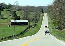
As with most American cities, transportation in Louisville, Kentucky, is based primarily on automobiles. However, the city traces its foundation to the era where the river was the primary means of transportation, and railroads have been an important part of local industry for over a century. In more recent times Louisville has become a national hub for air cargo, creating over 20,000 local jobs. The city has also launched several initiatives to promote both utilitarian and recreational bicycling. In 2016 Walk Score ranked Louisville 43rd "most walkable" of 141 U.S. cities with a population greater than 200,000. In 2015, 11.7 percent of Louisville households were without a car, which decreased to 10.9 percent in 2016. The national average was 8.7 percent in 2016. Louisville averaged 1.61 cars per household in 2016, compared to a national average of 1.8 per household.
Transportation in New York is made up of some of the most extensive and one of the oldest transportation infrastructures in the country. Engineering difficulties because of the terrain of the State of New York and the unique issues of New York City brought on by urban crowding have had to be overcome since the state was young. Population expansion of the state generally followed the path of the early waterways, first the Hudson River and then the Erie Canal. Today, railroad lines and the New York State Thruway follow the same general route.

Ashland Transportation Center is an intermodal transit station in Ashland, Kentucky. Jointly operated by the City of Ashland and CSX Transportation, it currently serves Amtrak's Cardinal train as well as the Ashland Bus System, Greyhound Lines, and regional shuttles. It is located at 99 15th Street near downtown Ashland.

California's transportation system is complex and dynamic. Although known for its car culture and extensive network of freeways and roads, the state also has a vast array of rail, sea, and air transport. Several subway, light rail, and commuter rail networks are found in many of the state's largest population centers. In addition, with the state's location on the West Coast of the United States, several important ports in California handle freight shipments from the Pacific Rim and beyond. A number of airports are also spread out across the state, ranging from small general aviation airports to large international hubs like Los Angeles International Airport and San Francisco International Airport.

Interstate 69 (I-69) in the US state of Kentucky is a 148.1-mile-long (238.3 km) freeway running from Fulton to Henderson. The route makes use of the Purchase Parkway and existing portions of I-24, the Western Kentucky Parkway, and the Pennyrile Parkway. Eventually, I-69 will leave the former Pennyrile Parkway just south of the Audubon Parkway interchange or remain on its current alignment and travel through Henderson on U.S. Route 41 (US 41) north into Indiana. The proposed route for the remainder of I-69 in Kentucky travels about 10 miles (16 km) before exiting on a bridge across the Ohio River to Indiana. As of April 2024, it is in early stages of development.

Interstate 65 (I-65) enters the US state of Kentucky from Tennessee, five miles (8.0 km) south of Franklin. It passes by the major cities of Bowling Green, Elizabethtown, and Louisville before exiting the state into Indiana.

Transportation in New Jersey utilizes a combination of road, rail, air, and water modes. New Jersey is situated between Philadelphia and New York City, two major metropolitan centers of the Boston-Washington megalopolis, making it a regional corridor for transportation. As a result, New Jersey's freeways carry high volumes of interstate traffic and products. The main thoroughfare for long distance travel is the New Jersey Turnpike, the nation's fifth-busiest toll road. The Garden State Parkway connects the state's densely populated north to its southern shore region. New Jersey has the 4th smallest area of U.S. states, but its population density of 1,196 persons per sq. mi causes congestion to be a major issue for motorists.
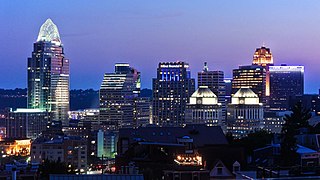
Transportation in Cincinnati includes sidewalks, roads, public transit, bicycle paths, and regional and international airports. Most trips are made by car, with transit and bicycles having a relatively low share of total trips; in a region of just over 2 million people, less than 80,000 trips are made with transit on an average day. The city is sliced by three major interstate highways, I-71, I-74 and I-75, and circled by a beltway several miles out from the city limits. The region is served by two separate transit systems, one on each side of the river. SORTA, on the Ohio side is about six times larger than TANK on the Kentucky side.
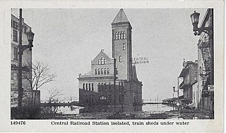
Central Station was a major train station in Louisville, Kentucky. Built in the Richardsonian Romanesque style, it served several railroad companies until the mid-20th century. It was situated at North 7th Street and West River Road, near the Ohio River waterfront, and it was also known as the 7th Street Depot.