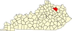
Fleming County, Kentucky

Last updated

Fleming County
Fleming County, Kentucky courthouse 2.jpg
Fleming County courthouse in Flemingsburg
Map of Kentucky highlighting Fleming County.svg
Location within the U.S. state of Kentucky
Kentucky in United States.svg
Kentucky's location within the U.S.
Coordinates: 38°22′N83°41′W / 38.37°N 83.69°W / 38.37; -83.69
CountryFlag of the United States.svg United States
StateFlag of Kentucky.svg  Kentucky
Founded1798
Named for John Fleming (1735–1791), early settler of Kentucky
Seat Flemingsburg
Largest cityFlemingsburg
Area
  Total351 sq mi (910 km2)
  Land349 sq mi (900 km2)
  Water2.8 sq mi (7 km2)  0.8%
Population
 (2020)
  Total15,082
  Estimate 
(2023)
15,442 Increase2.svg
  Density43/sq mi (17/km2)
Time zone UTC−5 (Eastern)
  Summer (DST) UTC−4 (EDT)
Congressional district 6th
Website www.flemingkychamber.com

Fleming County is a county located in the U.S. state of Kentucky. As of the 2020 census, the population was 15,082. [1] Its county seat is Flemingsburg. [2] The county was formed in 1798 and named for Colonel John Fleming, an Indian fighter and early settler. [3] [4] It is a moist county. In 1998, the Kentucky General Assembly designated Fleming County as the Covered Bridge Capital of Kentucky. [5]

Contents

History

Fleming County was established in 1798 from land given by Mason County. [6] The first courthouse, possibly built of logs, was replaced in 1830 and again in 1952. [7]

Geography

According to the United States Census Bureau, the county has a total area of 351 square miles (910 km2), of which 349 square miles (900 km2) is land and 2.8 square miles (7.3 km2) (0.8%) is water. [8]

Adjacent counties

Demographics

Historical population
CensusPop.Note
1800 5,016
1810 8,94778.4%
1820 12,18636.2%
1830 13,49910.8%
1840 13,268−1.7%
1850 13,9144.9%
1860 12,489−10.2%
1870 13,3987.3%
1880 15,22113.6%
1890 16,0785.6%
1900 17,0746.2%
1910 16,066−5.9%
1920 15,614−2.8%
1930 12,931−17.2%
1940 13,3273.1%
1950 11,962−10.2%
1960 10,890−9.0%
1970 11,3664.4%
1980 12,3238.4%
1990 12,292−0.3%
2000 13,79212.2%
2010 14,3484.0%
2020 15,0825.1%
2023 (est.)15,442 [9] 2.4%
U.S. Decennial Census [10]
1790-1960 [11] 1900-1990 [12]
1990-2000 [13] 2010-2020 [1]

As of the census of 2000, there were 13,792 people, 5,367 households, and 3,966 families residing in the county. The population density was 39 people per square mile (15 people/km2). There were 6,120 housing units at an average density of 17 per square mile (6.6/km2). The racial makeup of the county was 97.33% White, 1.41% Black or African American, 0.14% Native American, 0.17% Asian, 0.28% from other races, and 0.67% from two or more races. 0.75% of the population were Hispanic or Latino of any race.

There were 5,367 households, out of which 34.80% had children under the age of 18 living with them, 60.30% were married couples living together, 9.60% had a female householder with no husband present, and 26.10% were non-families. 23.30% of all households were made up of individuals, and 11.00% had someone living alone who was 65 years of age or older. The average household size was 2.55 and the average family size was 2.99.

In the county, the population was spread out, with 25.40% under the age of 18, 8.40% from 18 to 24, 29.00% from 25 to 44, 23.90% from 45 to 64, and 13.40% who were 65 years of age or older. The median age was 36 years. For every 100 females there were 96.00 males. For every 100 females age 18 and over, there were 93.20 males.

The median income for a household in the county was $27,990, and the median income for a family was $33,300. Males had a median income of $26,463 versus $19,895 for females. The per capita income for the county was $14,214. About 14.80% of families and 18.60% of the population were below the poverty line, including 24.90% of those under age 18 and 20.10% of those age 65 or over.

Politics

United States presidential election results for Fleming County, Kentucky [14]
Year Republican Democratic Third party
No.%No.%No.%
2020 5,53478.30%1,47420.85%600.85%
2016 4,72275.43%1,34821.53%1903.04%
2012 3,78065.38%1,91133.05%911.57%
2008 3,43258.85%2,27939.08%1212.07%
2004 3,74960.44%2,40638.79%480.77%
2000 3,28263.37%1,81335.01%841.62%
1996 2,31348.55%1,91340.16%53811.29%
1992 2,04539.82%2,25743.95%83316.22%
1988 2,40953.27%2,08646.13%270.60%
1984 2,82463.33%1,61636.24%190.43%
1980 2,18950.73%2,05147.53%751.74%
1976 1,64741.35%2,31758.17%190.48%
1972 2,48462.38%1,45536.54%431.08%
1968 2,22053.28%1,40633.74%54112.98%
1964 1,66838.33%2,67861.53%60.14%
1960 2,77755.62%2,21644.38%00.00%
1956 2,74451.97%2,51947.71%170.32%
1952 2,59251.33%2,44648.44%120.24%
1948 2,08842.66%2,72255.62%841.72%
1944 2,66650.38%2,61249.36%140.26%
1940 2,85548.65%2,99951.11%140.24%
1936 2,74948.66%2,87950.96%210.37%
1932 2,63843.08%3,44256.21%440.72%
1928 3,79864.50%2,08635.43%40.07%
1924 2,57249.38%2,59049.72%470.90%
1920 2,96045.72%3,48853.88%260.40%
1916 1,83644.60%2,24054.41%411.00%
1912 1,40036.77%1,91550.30%49212.92%

Communities

Cities

Census-designated place

Unincorporated communities

Notable residents

See also

Related Research Articles

<span class="mw-page-title-main">Clay County, West Virginia</span> County in West Virginia, United States

Clay County is a county in the U.S. state of West Virginia. As of the 2020 census, the population was 8,051. Its county seat is Clay. The county was founded in 1858 and named in honor of Henry Clay, famous American statesman, member of the United States Senate from Kentucky and United States Secretary of State in the 19th century.

<span class="mw-page-title-main">McCracken County, Kentucky</span> County in Kentucky, United States

McCracken County is a county located in the far west portion of U.S. state of Kentucky. As of the 2020 census, the population was 67,875. The county seat and only municipality is Paducah. McCracken County was the 78th county formed in the state, having been created in 1825. It is part of the historic Jackson Purchase, territory sold by the Chickasaw people to General Andrew Jackson and Governor Isaac Shelby; this territory was located at the extreme western end of Kentucky.

<span class="mw-page-title-main">Wood County, West Virginia</span> County in West Virginia, United States

Wood County is a county in the U.S. state of West Virginia. As of the 2020 census, the population was 84,296, making it West Virginia's fifth-most populous county. Its county seat is Parkersburg. The county was formed in 1798 from the western part of Harrison County and named for James Wood, governor of Virginia from 1796 to 1799.

<span class="mw-page-title-main">Ritchie County, West Virginia</span> County in West Virginia, United States

Ritchie County is a county in the U.S. state of West Virginia. As of the 2020 census, the population was 8,444. Its county seat is Harrisville. The county was created in 1843 by the Virginia General Assembly and named for Richmond newspaper publisher Thomas Ritchie.

<span class="mw-page-title-main">Henry County, Tennessee</span> County in Tennessee, United States

Henry County is a county located on the northwestern border of the U.S. state of Tennessee, and is considered part of West Tennessee. As of the 2020 census, the population was 32,199. Its county seat is Paris. The county is named for the Virginia orator and American Founding Father Patrick Henry.

<span class="mw-page-title-main">Robertson County, Kentucky</span> County in Kentucky, United States

Robertson County is a county located in the U.S. Commonwealth of Kentucky. As of the 2020 census, the population was 2,193. Its county seat is Mount Olivet. The county is named for George Robertson, a Kentucky Congressman from 1817 to 1821. It is Kentucky's smallest county by both total area and by population.

<span class="mw-page-title-main">Ohio County, Kentucky</span> County in Kentucky, United States

Ohio County is a county located in the U.S. state of Kentucky. As of the 2020 census, the population was 23,772. Its county seat is Hartford, and its largest city is Beaver Dam. The county is named after the Ohio River, which originally formed its northern boundary. It is a moist county, which means that the sale of alcohol is only legal within certain city limits.

<span class="mw-page-title-main">Meade County, Kentucky</span> County in Kentucky, United States

Meade County is a county located in the U.S. state of Kentucky. As of the 2020 census, the population was 30,003. Its county seat is Brandenburg. The county was founded December 17, 1823, and named for Captain James M. Meade, who was killed in action at the Battle of River Raisin during the War of 1812. Meade County is part of the Elizabethtown-Fort Knox, KY Metropolitan Statistical Area, which is included in the Louisville/Jefferson County-Elizabethtown-Madison, KY-IN Combined Statistical Area.

<span class="mw-page-title-main">McLean County, Kentucky</span> County in Kentucky, United States

McLean County is a county located in the U.S. state of Kentucky. As of the 2020 census, the population was 9,152. Its county seat is Calhoun and its largest city is Livermore. McLean is a prohibition or dry county. McLean County is part of the Owensboro, KY Metropolitan Statistical Area, which has a population of some 114,752.

<span class="mw-page-title-main">Mason County, Kentucky</span> County in Kentucky, United States

Mason County is a county located in the U.S. state of Kentucky. As of the 2020 census, the population was 17,120. Its county seat is Maysville. The county was created from Bourbon County, Virginia in 1788 and named for George Mason, a Virginia delegate to the U.S. Constitutional Convention known as the "Father of the Bill of Rights". Mason County comprises the Maysville, KY Micropolitan Statistical Area, which is included in the Cincinnati-Wilmington-Maysville, OH-KY-IN Combined Statistical Area.

<span class="mw-page-title-main">Lyon County, Kentucky</span> County in Kentucky, United States

Lyon County is a county located in the U.S. state of Kentucky. As of the 2020 census, the population was 8,680. Its county seat is Eddyville. The county was formed from Caldwell County, Kentucky in 1854 and named for former Congressman Chittenden Lyon.

<span class="mw-page-title-main">Livingston County, Kentucky</span> County in Kentucky, United States

Livingston County is a county located in the U.S. state of Kentucky. As of the 2020 census, the population was 8,888. Its county seat is Smithland and its largest community is Ledbetter. The county was established in 1798 from land taken from Christian County and is named for Robert R. Livingston, a member of the Committee of Five that drafted the U.S. Declaration of Independence. The county was strongly pro-Confederate during the American Civil War and many men volunteered for the Confederate Army. Livingston County is part of the Paducah, KY-IL Metropolitan Statistical Area. It is a prohibition or dry county with the exception of Grand Rivers which voted to allow alcohol sales in 2016.

<span class="mw-page-title-main">Harrison County, Kentucky</span> County in Kentucky, United States

Harrison County is a county located in the U.S. state of Kentucky. As of the 2020 census, the population was 18,692. Its county seat is Cynthiana. The county was founded in 1793 and named for Colonel Benjamin Harrison, an advocate for Kentucky statehood, framer of the Kentucky Constitution, and Kentucky legislator.

<span class="mw-page-title-main">Hancock County, Kentucky</span> County in Kentucky, United States

Hancock County is a county located in the U.S. state of Kentucky. As of the 2020 census, the population was 9,095. Its county seat is in the city of Hawesville located in the Northern part of the county, and its largest city of Lewisport is located in the Northwestern part of the county.

<span class="mw-page-title-main">Crittenden County, Kentucky</span> County in Kentucky, United States

Crittenden County is a county in the U.S. state of Kentucky. At the 2020 census, the population was 8,990. Its county seat and only municipality is Marion. The county was formed in 1842 and named for John J. Crittenden, senator and future Governor of Kentucky.

<span class="mw-page-title-main">Casey County, Kentucky</span> County in Kentucky, United States

Casey County is a county located in the U.S. Commonwealth of Kentucky. As of the 2020 census, the population was 15,941. Its county seat is Liberty. The county was formed in 1806 from the western part of Lincoln County and named for Colonel William Casey, a pioneer settler who moved his family to Kentucky in 1779. It is the only Kentucky county entirely in the Knobs region. Casey County is home to annual Casey County Apple Festival, and is a prohibition or dry county. It is considered part of the Appalachian region of Kentucky.

<span class="mw-page-title-main">Carroll County, Kentucky</span> County in Kentucky, United States

Carroll County is a county located in the northern part of the U.S. state of Kentucky. Its county seat is Carrollton. The county was formed in 1838 and named for Charles Carroll of Carrollton, the last living signer of the Declaration of Independence. It is located at the confluence of the Kentucky and Ohio Rivers.

<span class="mw-page-title-main">Bath County, Kentucky</span> County in Kentucky, United States

Bath County is a county located in the U.S. state of Kentucky. As of the 2020 census, the population was 12,750. The county seat is Owingsville. The county was formed in 1811. Bath County is included in the Mount Sterling, KY Micropolitan Statistical Area, which is also included in the Lexington-Fayette–Richmond–Frankfort, KY combined statistical area.

<span class="mw-page-title-main">Ewing, Kentucky</span> City in Kentucky, United States

Ewing is a home rule-class city in Fleming County, Kentucky, in the United States. The population was 264 at the 2010 census.

<span class="mw-page-title-main">Flemingsburg, Kentucky</span> City in Kentucky, United States

Flemingsburg is a home rule-class city in Fleming County, Kentucky, in the United States. The population was 2,953 at the 2020 census, up from 2,658 at the 2010 census. It is the seat of Fleming County.

References

  1. 1 2 "State & County QuickFacts". United States Census Bureau. Retrieved February 26, 2023.
  2. "Find a County". National Association of Counties. Archived from the original on May 31, 2011. Retrieved June 7, 2011.
  3. Rennick, Robert M. (1987). Kentucky Place Names. University Press of Kentucky. p. 103. ISBN   0813126312 . Retrieved April 28, 2013.
  4. Gannett, Henry (1905). The Origin of Certain Place Names in the United States. Govt. Print. Off. pp.  127.
  5. Kentucky State Symbols Archived January 28, 2011, at the Wayback Machine
  6. Collins, Lewis (1882). Collins' Historical Sketches of Kentucky: History of Kentucky, Volume 2. Collins & Company. p. 26.
  7. Hogan, Roseann Reinemuth (1992). Kentucky Ancestry: A Guide to Genealogical and Historical Research. Ancestry Publishing. p. 230. ISBN   9780916489496 . Retrieved July 26, 2013.
  8. "2010 Census Gazetteer Files". United States Census Bureau. August 22, 2012. Archived from the original on August 12, 2014. Retrieved August 14, 2014.
  9. "Annual Estimates of the Resident Population for Counties: April 1, 2020 to July 1, 2023". United States Census Bureau. Retrieved March 14, 2024.
  10. "U.S. Decennial Census". United States Census Bureau. Retrieved August 14, 2014.
  11. "Historical Census Browser". University of Virginia Library. Archived from the original on August 11, 2012. Retrieved August 14, 2014.
  12. "Population of Counties by Decennial Census: 1900 to 1990". United States Census Bureau. Retrieved August 14, 2014.
  13. "Census 2000 PHC-T-4. Ranking Tables for Counties: 1990 and 2000" (PDF). United States Census Bureau. Archived (PDF) from the original on March 27, 2010. Retrieved August 14, 2014.
  14. Leip, David. "Dave Leip's Atlas of U.S. Presidential Elections". uselectionatlas.org. Retrieved April 10, 2018.

38°22′N83°41′W / 38.37°N 83.69°W / 38.37; -83.69