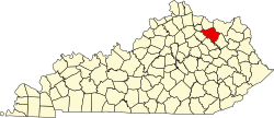
Sherburne, Kentucky

Last updated

Sherburne, Kentucky
USA Kentucky location map.svg
Red pog.svg
Sherburne
Location within the state of Kentucky
Coordinates: 38°16′54″N83°48′10″W / 38.28167°N 83.80278°W / 38.28167; -83.80278
Country United States
State Kentucky
County Fleming
Elevation
[1]
637 ft (194 m)
Time zone UTC-5 (Eastern (EST))
  Summer (DST) UTC-4 (EDT)
ZIP code
41041
Area code 606
GNIS feature ID503354 [1]

Sherburne is an unincorporated community in Fleming County, Kentucky, in the United States. [1]

History

Sherburne was incorporated in 1847. [2] The post office opened in 1815 under the name Sherburne Mills and was renamed Sherburne in 1879. [3] The Sherburne post office was discontinued in 1958. [4]

Related Research Articles

<span class="mw-page-title-main">Trimble County, Kentucky</span> County in Kentucky, United States

Trimble County is a county located in the north central part of the U.S. state of Kentucky. Its county seat is Bedford. The county was founded in 1837 and is named for Robert Trimble. Trimble is no longer a prohibition or dry county. Trimble County is part of the Louisville/Jefferson County, KY–IN Metropolitan Statistical Area.

<span class="mw-page-title-main">Rowan County, Kentucky</span> County in Kentucky, United States

Rowan County is a county located in the northeastern part of the U.S. state of Kentucky, in the Eastern Kentucky Coalfield region. As of the 2020 census, the population was 24,662. Its county seat is Morehead.

<span class="mw-page-title-main">Fleming County, Kentucky</span> County in Kentucky, United States

Fleming County is a county located in the U.S. state of Kentucky. As of the 2020 census, the population was 15,082. Its county seat is Flemingsburg. The county was formed in 1798 and named for Colonel John Fleming, an Indian fighter and early settler. It is a moist county. In 1998, the Kentucky General Assembly designated Fleming County as the Covered Bridge Capital of Kentucky.

<span class="mw-page-title-main">Ewing, Kentucky</span> City in Kentucky, United States

Ewing is a home rule-class city in Fleming County, Kentucky, in the United States. The population was 264 at the 2010 census.

<span class="mw-page-title-main">Flemingsburg, Kentucky</span> City in Kentucky, United States

Flemingsburg is a home rule-class city in Fleming County, Kentucky, in the United States. The population was 2,658 at the 2010 census, down from 3,010 at the 2000 census. It is the seat of Fleming County.


Nepton is an unincorporated community in Fleming County, Kentucky, United States. A post office was built for the community in 1881, and closed in 1958.

<span class="mw-page-title-main">Robert B. McAfee</span> American politician

Robert Breckinridge McAfee was an American diplomat, historian and politician who was the seventh Lieutenant Governor of Kentucky serving from 1824 to 1828.

Colonel William Fleming was an American physician, soldier, politician, and planter who served as a local justice of the peace in the mountains of southwestern Virginia and Kentucky, as well as in the Senate of Virginia and briefly acted as the Governor of Virginia during the American Revolutionary War.

<span class="mw-page-title-main">Horatio Washington Bruce</span> American politician

Horatio Washington Bruce was a Confederate politician during the American Civil War.

Santiago is an unincorporated community in Santiago Township, Sherburne County, Minnesota, United States, near the junction of Sherburne County Roads 3 and 11. The St. Francis River flows through the community.

<span class="mw-page-title-main">Elizaville, Kentucky</span> Census-designated place in Kentucky, United States

Elizaville is a census-designated place and unincorporated community in Fleming County, Kentucky, United States. Its population was 181 as of the 2010 census. Elizaville is located at the junction of Kentucky Route 32 and Kentucky Route 170, 5 miles (8.0 km) west of Flemingsburg. Elizaville has a post office with ZIP code 41037.

Kneeland is an unincorporated community in Humboldt County, California. It is located 7.5 miles (12 km) south-southwest of Korbel, at an elevation of 2,129 feet (649 m). Kneeland Airport is nearby. The ZIP code is 95549.

Neon is an unincorporated community in Letcher County, Kentucky, United States. The Neon Post Office does exist. It was also known as Fleming-Neon.

Goddard is an unincorporated community in Fleming County, Kentucky, United States. Goddard is located on Kentucky Route 32, 7.7 miles (12.4 km) east-southeast of Flemingsburg. Goddard Bridge, which is listed on the National Register of Historic Places, is located in Goddard.

Hillsboro is an unincorporated community in Fleming County, Kentucky, United States. Hillsboro is located at the junction of Kentucky Route 111 and Kentucky Route 158, 9.8 miles (15.8 km) south-southeast of Flemingsburg.

Tilton is an unincorporated community in Fleming County, Kentucky, in the United States.

Poplar Plains is an unincorporated community in Fleming County, Kentucky, in the United States.

Mount Carmel is an unincorporated community in Fleming County, Kentucky, in the United States.

Hemphill, also known as Jackhorn, is an unincorporated community in Letcher County, Kentucky. The community is located on Kentucky Route 317 1.7 miles (2.7 km) north of Fleming-Neon. The community has a post office with ZIP code 41825, which uses the Jackhorn name.

Wallingford is an unincorporated community in Fleming County, Kentucky, United States. The community is located along Kentucky Route 559 6.7 miles (10.8 km) east of Flemingsburg. Wallingford has a post office with ZIP code 41093.

References

  1. 1 2 3 U.S. Geological Survey Geographic Names Information System: Sherburne, Kentucky
  2. Collins, Lewis (1877). History of Kentucky. p. 230.
  3. "Sherburne, Kentucky". Kentucky Atlas & Gazetter. David C. Eldon. Retrieved February 9, 2019.
  4. "Fleming County". Jim Forte Postal History. Retrieved January 4, 2015.