Eastern Kentucky Coalfield

Last updated

Counties of the Eastern Mountain Coalfields of Kentucky highlighted in red Eastern-ky.png
Counties of the Eastern Mountain Coalfields of Kentucky highlighted in red
Daniel Boone National Forest in Kentucky Daniel Boone National Forest Tater Knob.jpg
Daniel Boone National Forest in Kentucky
Cumberland Falls in Kentucky Cumberland Falls, Whitley County, Kentucky.JPG
Cumberland Falls in Kentucky
Breaks Interstate Park in Kentucky Breaks Canyon Fall.jpg
Breaks Interstate Park in Kentucky

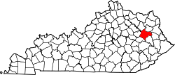
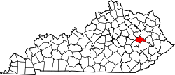
The Eastern Kentucky Coalfield is part of the Central Appalachian bituminous coalfield, including all or parts of 30 Kentucky counties and adjoining areas in Ohio, West Virginia, Virginia, and Tennessee. [3] It covers an area from the Allegheny Mountains in the east across the Cumberland Plateau to the Pottsville Escarpment in the west. The region is known for its coal mining; most family farms in the region have disappeared since the introduction of surface mining in the 1940s and 1950s.

Contents

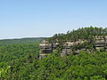
The Daniel Boone National Forest is located on rough but beautiful[ citation needed ] terrain along and east of the Pottsville Escarpment. There are many natural arches and sandstone cliffs that are excellent for rock climbing and rappeling.[ citation needed ] The Red River Gorge, part of the National Forest, is known worldwide in rock climbing circles. [4]

The Sheltowee Trace Trail runs 260–270 mi (420–430 km) north and south, through the region.

During the American Civil War most of this region leaned toward the Union due to its makeup at the time of mostly small farmers, but more than 2,000 men from this area formed the 5th. Kentucky Vol. Inf., known as the Army of Eastern Kentucky, under Gen. Humphrey Marshall, C.S.A. During the Great Depression, New Deal programs and the organizing of the United Mine Workers of America made many of the eastern counties Democratic.

Eastern Kentucky has a rich musical heritage. Many nationally acclaimed country music singers and musicians are from the area. These include: Loretta Lynn, Crystal Gayle, The Judds, Ricky Skaggs, Keith Whitley, Patty Loveless, Dwight Yoakam, Tom T. Hall, Billy Ray Cyrus, Jean Ritchie, Sturgill Simpson, Tyler Childers, Chris Stapleton, and George S. Davis.

As of the 1980s, the only counties in the United States where over half of the population cited "English" as their only ancestry group were in the hills of eastern Kentucky (and made up nearly every county in this region). [5] In the 1980 census, 1,267,079 Kentuckians out of a total population of 2,554,359 cited that they were of English ancestry, making them 49 percent of the state at that time. Large numbers of people of Scottish and Irish ancestry settled the area as well. [6]

Geography

The Eastern Kentucky Coalfield covers 31 counties with a combined land area of 13,370 sq mi (34,628 km2), or about 33.1 percent of the state's land area. Its 2000 census population was 734,194 inhabitants, or about 18.2 percent of the state's population. The largest city, Ashland, has a population of 21,981. Other cities of significance in the region include Pikeville, London, and Middlesboro. The state's highest point, Black Mountain, is located in the southeastern part of the region in Harlan County.

Counties

Major cities

Ashland, the region's largest city Downtown Ashland Kentucky.jpg
Ashland, the region's largest city

The following list consists of Eastern Kentucky cities with populations over 4,000 according to the 2020 United States Census: [9]

RankCityPopulation in 2020County
1 Ashland 21,625 Boyd
2 Middlesboro 9,405 Bell
3 Corbin 7,856 Whitley and Knox
4 Pikeville 7,754 Pike
5 London 7,572 Laurel
6 Mount Sterling 7,558 Montgomery
7 Flatwoods 7,325 Greenup
8 Morehead 7,151 Rowan
9 Williamsburg 5,326 Whitley
10 Hazard 5,263 Perry
11 Paintsville 4,312 Johnson

Protected areas

Natural Bridge State Resort Park Natural Bridge (Kentucky).jpg
Natural Bridge State Resort Park

Historical parks

State resort parks

State recreational parks

Levi Jackson Wilderness Road State Park in Laurel County, Kentucky McHargue's Mill.jpg
Levi Jackson Wilderness Road State Park in Laurel County, Kentucky

Other

Economy

The region's economy is centered around the natural resources available, which includes coal, timber, natural gas, and oil. Recently, tourism has become a leading industry in the region, due to the region's cultural history and the creation of state parks.

Calgon Carbon constructed the Big Sandy Plant near Ashland in 1961 and it has since become the world's largest producer of granular activated carbon. The facility produces over 100 million pounds of granular activated carbon annually. [10]

Persistent poverty

Most of the counties in the Eastern Kentucky Coalfield are classified as "persistent poverty counties". The definition of a persistent poverty county by the Economic Research Service of the United States Department of Agriculture is that 20 percent or more of the total county population has been living in poverty since the 1980 census. [11]

A June 2014 article in The New York Times identified six counties in the Kentucky Coal Field as among the "hardest places to live in the United States." The lowest-ranking counties were Breathitt, Clay, Jackson, Lee, Leslie, and Magoffin. They ranked among the bottom ten counties nationwide. The factors which accounted for the low ranking of those six counties were unemployment, prevalence of disabilities, obesity, income, and education. [12] The Times declared Clay County the hardest place to live in the U.S. [13]

Appalachian Regional Commission

The Appalachian Regional Commission was formed in 1965 to aid economic development in the Appalachian region, which was lagging far behind the rest of the nation on most economic indicators. The Appalachian region currently defined by the Commission includes 420 counties in 13 states, including all counties in Kentucky's Eastern Coalfield. The Commission gives each county one of five possible economic designations—distressed, at-risk, transitional, competitive, or attainment—with "distressed" counties being the most economically endangered and "attainment" counties being the most economically prosperous. These designations are based primarily on three indicators—three-year average unemployment rate, market income per capita, and poverty rate. [14]

From 2012 to 2014, "Appalachian" Kentucky—which includes all of the Eastern Coalfield and several counties in South Central Kentucky and a few in the eastern part of the Bluegrass region—had a three-year average unemployment rate of 9.8%, compared with 7.6% statewide and 7.2% nationwide. [14] In 2014, Appalachian Kentucky had a per capita market income of $18,889, compared with $28,332 statewide and $38,117 nationwide. From 2010 to 2014, Appalachian Kentucky had an average poverty rate of 25.4%—the highest of any of the ARC regions—, compared to 18.9% statewide and 15.6% nationwide. Twenty-five Eastern Mountain Coal Field counties—Bell, Breathitt, Carter, Clay, Elliott, Floyd, Harlan, Jackson, Johnson, Knott, Knox, Lawrence, Lee, Leslie, Letcher, Magoffin, Martin, McCreary, Menifee, Morgan, Owsley, Powell, Rowan, Whitley, and Wolfe—were designated "distressed," while four – Laurel, Montgomery, Perry, and Pike – were designated "at-risk." Two Eastern Coalfield counties were designated "transitional" — Boyd and Greenup. No counties in the Eastern Coalfields region were given the "attainment" designation or were designated "competitive."

The following table illustrates the economic status of each county.

CountyPopulation (2010)Unemployment Rate (2012–14) [14] Per Capita
Market Income (2014) [14]
Poverty Rate (2010–14) [14] Status (2017) [14]
Bell 28,69111.9%$14,64432.7%Distressed
Boyd 49,5428.6%$24,33719.1%Transitional
Breathitt 13,87813.7%$14,38631.5%Distressed
Carter 27,72012.0%$18,01418.7%Distressed
Clay 21,73013.3%$11,53135.7%Distressed
Elliott 7,85213.5%$10,52939.6%Distressed
Floyd 39,45111.7%$18,47329.5%Distressed
Greenup 36,9109.3%$23,87918.0%Transitional
Harlan 29,27815.4%$13,62032.1%Distressed
Jackson 13,49415.4%$13,49631.7%Distressed
Johnson 23,35610.1%$19,00825.3%Distressed
Knott 16,34613.5%$14,27126.5%Distressed
Knox 31,88311.9%$15,54933.8%Distressed
Laurel 58,8499.2%$21,05123.3%At-Risk
Lawrence 15,86010.5%$15,39923.5%Distressed
Lee 7,88711.7%$11,75033.4%Distressed
Leslie 11,31015.0%$15,35723.9%Distressed
Letcher 24,51914.2%$15,95524.5%Distressed
Magoffin 13,33316.3%$11,13926.8%Distressed
Martin 12,9299.4%$14,82633.9%Distressed
McCreary 18,30612.4%$9,76337.7%Distressed
Menifee 6,30611.2%$15,65628.8%Distressed
Montgomery 26,4998.2%$23,09325.2%At-Risk
Morgan 13,92310.3%$13,45129.7%Distressed
Owsley 4,75511.9%$10,52839.2%Distressed
Perry 28,71212.3%$20,13126.6%Distressed
Pike 68,73610.6%$21,28524.1%At-Risk
Powell 12,61310.1%$18,40327.5%Distressed
Rowan 23,3337.8%$18,64226.0%At-Risk
Whitley 35,63710.0%$17,32124.1%Distressed
Wolfe 7,35513.3%$10,53244.3%Distressed

Health

Most of the counties in the Eastern Kentucky Coalfield rank in the lowest ten percent of U.S. counties in average life expectancy. Both men and women have average life spans that are several years less than the average life span in the United States. Moreover, many counties have seen a decline in the life expectancy of men and/or women since 1985. Average life expectancy in some counties is as low as 70 years as compared with the life expectancy of some counties in the U.S. of more than 80 years. Factors influencing the health of residents include a high prevalence of smoking and obesity and a low level of physical activity. [15]

Post-secondary education

The Coal Building, University of Pikeville Kentucky College of Osteopathic Medicine University of Pikeville pedestrian entrance.jpg
The Coal Building, University of Pikeville Kentucky College of Osteopathic Medicine
Morehead State University Aduc1.jpg
Morehead State University

Public universities

Contrary to what its name suggests, Eastern Kentucky University is actually located outside of the Eastern Coalfield, in the Bluegrass-region city of Richmond.

Private colleges and universities

Community and technical colleges

Political climate

As a whole, East Kentucky was long a Democratic stronghold, similar to Appalachia as a whole. [16] The only two counties in the state to vote against Mitch McConnell in each of his six senatorial campaigns through 2020 have been Wolfe and Elliott Counties, both in East Kentucky. However, the region has swung dramatically to the right recently, similar to neighboring West Virginia. In 2004, eleven counties in East Kentucky supported Democratic candidate John Kerry, and in 2008, even as the nation as a whole shifted Democratic, the number of East Kentucky counties supporting Democratic candidate Barack Obama fell to just four, and in 2012 fell to just one. [17] Every county in East Kentucky supported Donald Trump in both 2016 and 2020 with at least 50% of the vote. In fact, each of the three most Republican counties in Kentucky (in terms of vote proportion) were all in East Kentucky (namely Leslie, Jackson and Martin Counties). Each gave less than a tenth of their vote to Hillary Clinton, the Democratic candidate.

Elliott County, Kentucky, serves as a good representation of the political transformation throughout the region. The county had the longest streak in the nation of any county voting Democratic, [17] but has shifted hard to the right in recent elections. The county went from giving Democrat Barack Obama more than 60% of the vote in 2008 to giving Republican Donald Trump more than 70% of the vote just eight years later. Despite this, Democrats continue to do well in local elections, and the party maintains an overwhelming advantage in party registration. Much of this area is represented by Kentucky's 5th congressional district represented by 22-term congressman Hal Rogers, who also serves as the Dean of the United States House of Representatives.

United States presidential election results for Eastern Kentucky Coalfields
Year Republican Democratic Third party(ies)
No.%No.%No.%
2020 213,84179.19%53,12219.67%3,0601.13%
2016 197,95778.45%46,87018.57%7,5082.98%
2020 133.33%133.33%133.33%

Notable residents

See also

References

  1. "Kentucky Atlas and Gazetteer". March 28, 2008. Archived from the original on March 28, 2008. Retrieved May 7, 2018.{{cite web}}: CS1 maint: bot: original URL status unknown (link)
  2. "National Digital Newspaper Program: The Kentucky Edition, More about KY-NDNP: regions". Uky.edu. November 6, 2007. Archived from the original on October 1, 2013. Retrieved November 5, 2013.
  3. Eastern Mountain Coal Fields Archived October 1, 2013, at the Wayback Machine Retrieved on January 30, 2010
  4. "Climbing in the Red River Gorge". Red River Gorge. RRG Tourism. Retrieved August 21, 2021.
  5. James Paul Allen and Eugene James Turner, We the People: An Atlas of America's Ethnic Diversity (Macmillan, 1988), 41.
  6. "Archived copy" (PDF). Archived (PDF) from the original on February 24, 2012. Retrieved February 10, 2012.{{cite web}}: CS1 maint: archived copy as title (link)
  7. "EPA County FIPS Code Listing". EPA. Archived from the original on September 22, 2004. Retrieved April 9, 2007.
  8. 1 2 3 4 National Association of Counties. "NACo – Find a county". Archived from the original on July 11, 2007. Retrieved July 22, 2007.
  9. Annual Estimates of the Resident Population: April 1, 2010 to July 1, 2016 Population Estimates U.S. Census Bureau. Retrieved August 13, 2015
  10. Calgon Carbon Big Sandy Plant Retrieved March 21, 2014.
  11. "Geography of Poverty", "USDA ERS – Geography of Poverty". Archived from the original on February 17, 2017. Retrieved February 17, 2017., accessed February 17, 2017
  12. Lowrey, Annie (June 29, 2014). "What's the Matter With Eastern Kentucky?". The New York Times . Archived from the original on December 1, 2017.
  13. Flippen, Alan (June 26, 2014), "Where Are the Hardest Places to Live in the U.S.?" The New York Times.
  14. 1 2 3 4 5 6 County Economic Status, Fiscal Year 2017: Appalachian Kentucky Archived May 14, 2017, at the Wayback Machine . ARC. Retrieved: July 14, 2017.
  15. "Institute for Health Metrics and Evaluation", "US Health Map | IHME Viz Hub". Archived from the original on February 24, 2017. Retrieved February 17, 2017., accessed February 17, 2017
  16. Schwartzman, Gabe; ‘How Central Appalachia Went Right’; Daily Yonder, January 13, 2015
  17. 1 2 Nelson, Eliot (May 10, 2013). "Not So Solid South: Democratic Party Survives In Rural Elliott County, Kentucky".
  18. "Earle Combs / Baseball Legend". March 15, 2012. Archived from the original on March 15, 2012.

Further reading

37°45′N83°05′W / 37.750°N 83.083°W / 37.750; -83.083