This article is about the meteorite impact crater in Kentucky. For the meteorite that impacted in Middlesbrough, England in 1881, see Middlesbrough meteorite.
Middlesboro crater
Middlesborough astrobleme
The city of Middlesboro is built within the crater
The crater is approximately 3 miles (about 5km) wide and its age is estimated to be less than 300 million years (Permian). The impactor is estimated to have been about 100 m in diameter.
The town of Middlesboro, built in the crater, was established in 1886 to exploit iron and coal deposits,[3] although the town's founder, Alexander A. Arthur, apparently did not know of the crater's extraterrestrial origin. K. J. Englund and J. B. Roen, working for the U. S. Geological Survey, identified the impact basin in 1962.[4]
Geological features
The 12-mile (19km) long Cumberland Gap consists of four geologic features: the Yellow Creek valley, the natural gap in the Cumberland Mountain ridge, the eroded gap in Pine Mountain, and Middlesboro crater.
Middlesboro crater is a 3-mile (4.8km) diameter meteoriteimpact crater in which Middlesboro, Kentucky, is located. The crater was identified in 1966 when Robert Dietz discovered shatter cones in sandstone, which led to the further identification of shocked quartz. Shatter cones, a rock shattering pattern naturally formed only during impact events, are found in abundance in the area. In September 2003 the site was designated a Distinguished Geologic Site by the Kentucky Society of Professional Geologists.[5]
Without the Middlesboro crater, it would have been difficult for packhorses to navigate this gap, formed by differential erosion along one of the subsequent cross faults, [citation needed] and improbable that wagon roads would have been constructed at an early date. Middlesboro is the only place in the world where coal is mined inside an impact crater. Special mining techniques must be used in the complicated strata of this crater. (Milam & Kuehn, 36).
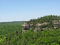
Panoramic view from Pinnacle Overlook at Cumberland Gap National Historic Park
This page is based on this Wikipedia article Text is available under the CC BY-SA 4.0 license; additional terms may apply. Images, videos and audio are available under their respective licenses.