Kingdom Come State Park

Last updated

Kingdom Come State Park
USA Kentucky location map.svg
Red pog.svg
Location in Kentucky
Usa edcp location map.svg
Red pog.svg
Location in United States
Type Kentucky state park
Location Harlan County, Kentucky
Coordinates 36°59′48″N82°58′44″W / 36.99667°N 82.97889°W / 36.99667; -82.97889
Area1,283 acres (519 ha) [1]
CreatedJune 11, 1961 [2]
Operated byKentucky Department of Parks
StatusOpen year-round
Website Official website

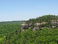
Kingdom Come State Park is a part of Kentucky's state park system in Harlan County atop Pine Mountain near the city of Cumberland. It was named after the 1903 best-selling novel The Little Shepherd of Kingdom Come by native Kentuckian John Fox, Jr. [2] Features of the park include Raven Rock, Log Rock, and a 3.5-acre (1.4 ha) mountain lake. The section of the park is also a legally dedicated state nature preserve by the Office of Kentucky Nature Preserves.

Contents

Park features

Natural formations

Raven Rock is a naturally bare, large rock face composed mostly of limestone, leaning at a 45° angle over 290 feet (88 m) in the air. [1] Nearby is the Cave Amphitheater. In the back of the Cave Amphitheater are deep crevices that house thousands of bats. Also within the park is a natural sandstone bridge called "Log Rock", which resembles a petrified tree that has fallen over. The Log Rock has been severely vandalized over the years, and the underside is now covered with people's names that they have spray-painted or scratched onto the stone. There are also numerous overlooks to the valleys below. Among the most popular of these viewing points is the Creech Overlook.[ citation needed ]

Wildlife

Black bears inhabit Kingdom Come State Park and adjoining lands in the Cumberland, Kentucky area. Black bears naturally recolonized extreme eastern Kentucky counties (Harlan, Letcher, Bell, and Pike) over the last three decades[ when? ] from the neighboring states of Virginia, West Virginia, and Tennessee. The species was not reintroduced to Kingdom Come State Park or any portion of Kentucky east of Interstate 75. [3] It is illegal to feed black bears. [4]

Other wildlife species also call Kingdom Come State Park home, including the state-threatened common raven, fox, multiple species of hawks, cottontail rabbit, multiple bat species, coyote, multiple species of amphibians, and an array of insect life.

Activities and amenities

Fourteen hiking trails, a 9-hole miniature golf course, lake with paddle boats, picnic shelters, fishing, and primitive campsites are available at the park. The park offers access to Little Shepherd Trail, a 38-mile (61 km) primitive road for mountain biking and adventure driving that winds across the Pine Mountain ridgetop to the city of Harlan. [5] [6]

Nearby

The Kentucky Coal Mining Museum, Portal 31 Mine Tour, and Benham Schoolhouse Inn are operated by the Kentucky Community and Technical College System in Benham. [7]

Related Research Articles

<span class="mw-page-title-main">Letcher County, Kentucky</span> County in Kentucky, United States

Letcher County is a county located in the U.S. state of Kentucky. As of the 2020 census, the population was 21,548. Its county seat is Whitesburg. It was created in 1842 from Harlan and Perry counties, and named for Robert P. Letcher, Governor of Kentucky from 1840 to 1844.

<span class="mw-page-title-main">Harlan County, Kentucky</span> County in Kentucky, United States

Harlan County is a county located in southeastern Kentucky. As of the 2020 census, the population was 26,831. Its county seat is Harlan. It is classified as a moist county—a county in which alcohol sales are prohibited, but containing a "wet" city, in this case Cumberland, where package alcohol sales are allowed. In the city of Harlan, restaurants seating 100+ may serve alcoholic beverages.

<span class="mw-page-title-main">Benham, Kentucky</span> City in Kentucky, United States

Benham is a home rule-class city in Harlan County, Kentucky, in the United States. The city was formally incorporated by the General Assembly in 1961. The population was 512 at the 2020 census, up from 500 at the 2010 census.

<span class="mw-page-title-main">Cumberland, Kentucky</span> City in Kentucky, United States

Cumberland is a home rule-class city in Harlan County, Kentucky, in the United States. The population according to the 2010 Census was 2,237, down from 2,611 at the 2000 census.

<span class="mw-page-title-main">Daniel Boone National Forest</span> National forest in Kentucky

The Daniel Boone National Forest is a national forest in Kentucky. Established in 1937, it includes 708,000 acres (287,000 ha) of federally owned land within a 2,100,000-acre (850,000 ha) proclamation boundary. The name of the forest was changed in 1966 in honor of the explorer Daniel Boone.

<span class="mw-page-title-main">Gorges State Park</span> State park in North Carolina, United States

Gorges State Park is a 7,709-acre (31.20 km2) North Carolina state park in Transylvania County, North Carolina in the United States and along with other conservation lands is part of a 100,000+ acre conservation corridor stretching some 80 miles along the NC/SC state line. The land, along Jocassee Gorges, was purchased by the state from Duke Energy Corporation in 1999. It is North Carolina's westernmost state park and one of the state's newest. The park is adjacent to part of the Pisgah National Forest and the N.C. Wildlife Resources Commission's Toxaway Game Land. Gorges State Park provides the principal access to the Horsepasture River on these adjoining public lands.

<span class="mw-page-title-main">Big South Fork of the Cumberland River</span> River in the United States

The Big South Fork of the Cumberland River is a 76-mile-long (122 km) river in the U.S. states of Tennessee and Kentucky. It is a major drainage feature of the Cumberland Plateau, a major tributary of the Cumberland River system, and the major feature of the Big South Fork National River and Recreation Area.

<span class="mw-page-title-main">Cumberland Gap National Historical Park</span> Historic area in Kentucky, Tennessee, and Virginia, U.S.

The Cumberland Gap National Historical Park is a United States National Historical Park located at the border between Kentucky, Tennessee, and Virginia, centered on the Cumberland Gap, a natural break in the Appalachian Mountains.

<span class="mw-page-title-main">Cumberland Gap</span> Narrow pass through the Cumberland Mountains

The Cumberland Gap is a pass in the eastern United States through the long ridge of the Cumberland Mountains, within the Appalachian Mountains and near the tripoint of Kentucky, Virginia, and Tennessee. At an elevation of 1,631 feet (497 m) above sea level, it is famous in American colonial history for its role as a key passageway through the lower central Appalachians.

<span class="mw-page-title-main">Justin P. Wilson Cumberland Trail State Park</span> Hiking trail in Tennessee, United States

The Justin P. Wilson Cumberland Trail State Park, commonly known as the Cumberland Trail, is a Tennessee hiking trail following a line of ridges and gorges along the eastern escarpment of the Cumberland Plateau and Cumberland Mountains in Tennessee. The trail begins at Cumberland Gap National Historical Park and ends at Chickamauga and Chattanooga National Military Park and Prentice Cooper Wildlife Management Area just outside Chattanooga, Tennessee. The trail travels through 11 Tennessee counties and two time zones.

<span class="mw-page-title-main">Chugach State Park</span> State park in Alaska, United States

Chugach State Park covers 495,204 acres covering a hilly region immediately east of Anchorage, in south-central Alaska.

<span class="mw-page-title-main">John Fox Jr.</span> American journalist, novelist and short story writer

John Fox Jr. was an American journalist, novelist, and short story writer.

<span class="mw-page-title-main">Frozen Head State Park</span> State park in Tennessee, United States

Frozen Head State Park and Natural Area is a state park in Morgan County, Tennessee, in the southeastern United States. The park, situated in the Crab Orchard Mountains between the city of Wartburg and the community of Petros, contains some of the highest mountains in Tennessee west of the Blue Ridge.

<span class="mw-page-title-main">Bad Branch Falls State Nature Preserve</span>

Bad Branch Falls State Nature Preserve is a forested gorge covering 2,639 acres near Whitesburg, KY in Letcher County, Kentucky. The deep and narrow gorge, adjacent to the Jefferson National Forest is carved into the face of Pine Mountain. Sandstone boulders and cliffs along with riglines and knobs provide views into the Appalachia area. The terrain is landscaped with streams, rivers, and a 60-foot waterfall. With a variety of habitat types, this nature preserve is home to many unique and unknown species of flora and fauna.

<span class="mw-page-title-main">Colonel Denning State Park</span> State park in Cumberland County, Pennsylvania

Colonel Denning State Park is a 273-acre (110 ha) Pennsylvania state park in Lower Mifflin Township, Cumberland County, Pennsylvania in the United States. The park is in the Doubling Gap of Blue Mountain on Pennsylvania Route 233 between Newville and Landisburg. Doubling Gap Lake is a man-made lake covering 3.5 acres (1.4 ha). Colonel Denning State Park is surrounded by Tuscarora State Forest.

<span class="mw-page-title-main">Cumberland Falls State Resort Park</span>

Cumberland Falls State Resort Park is a park located just southwest of Corbin, Kentucky and is contained entirely within the Daniel Boone National Forest. The park encompasses 1,657 acres (671 ha) and is named for its major feature, 68-foot-tall (21 m) Cumberland Falls. The falls are one of the few places in the western hemisphere where a moonbow can frequently be seen on nights with a full moon. The park is also the home of 44-foot (13 m) Eagle Falls. The section of the Cumberland River that includes the falls was designated a Kentucky Wild River by the Kentucky General Assembly through the Office of Kentucky Nature Preserves' Wild Rivers System. The forest in the park is also a dedicated State Nature Preserve.

<span class="mw-page-title-main">Paintsville Lake State Park</span> State park in Kentucky, United States

Paintsville Lake State Park is a park located just west of Paintsville, Kentucky in Johnson County. The park itself encompasses 242 acres (98 ha), while Paintsville Lake, its major feature, covers approximately 1,139 acres (461 ha) extending into parts of Morgan County.

<span class="mw-page-title-main">Pine Mountain (Appalachian Mountains)</span>

Pine Mountain is a ridge in the Appalachian Mountains running through Kentucky, Virginia and Tennessee. It extends about 125 miles from near Pioneer, Tennessee, to a location near Elkhorn City, Kentucky. Birch Knob, the highest point, is 3,273 feet (998 m) above sea level and is located on the Kentucky-Virginia border. It has long been a barrier to transportation, as the Cumberland River at Pineville, Kentucky is one of only two waterways that pass through the entire ridge. The other is the Clear Fork near Jellico, Tennessee.

<span class="mw-page-title-main">Davis Mountains State Park</span> State park in Texas, United States

Davis Mountains State Park is a 2,709-acre (1,096 ha) state park located in the Davis Mountains in Jeff Davis County, Texas. The closest town is Fort Davis, Texas. The park elevation is between 5,000 and 6,000 ft above sea level. The original portion of the park was deeded to Texas Parks and Wildlife Department by a local family.

<span class="mw-page-title-main">The Walls of Jericho (canyon)</span>

The Walls of Jericho is a 750-acre (300 ha) natural area that is within the 8,943-acre (3,619 ha) Bear Hollow Mountain Wildlife Management Area (WMA) in Tennessee, which is contiguous to the Skyline WMA in Alabama. It was designated in 2016 and is owned by State of Tennessee. Both of the public lands on the Tennessee and Alabama side total 21,453 acres (8,682 ha). The initiative to acquire this land was a lengthy project completed by The Nature Conservancy in Tennessee and Alabama. The natural area is approximately twelve miles south of Winchester in southern Franklin County.

References

  1. 1 2 "About". Kingdom Come State Park. Kentucky Department of Parks. Retrieved September 20, 2013.
  2. 1 2 "History". Kingdom Come State Park. Kentucky Department of Parks. Retrieved September 20, 2013.
  3. "Black Bears in Kentucky". Kentucky Department of Fish and Wildlife Resources. Archived from the original on September 21, 2013. Retrieved September 20, 2013.
  4. "Human-Bear Conflicts". Kentucky Department of Fish and Wildlife Resources. Archived from the original on September 21, 2013. Retrieved September 20, 2013.
  5. "Things to do". Kingdom Come State Park. Kentucky Department of Parks. Retrieved September 20, 2013.
  6. "Little Shepherd Trail & Kentennia State Forest". Harlan County, Kentucky. Harlan County Outdoor Recreation Board Authority. Retrieved September 20, 2013.
  7. "Kentucky Coal Museum and Portal 31". Kentucky Community and Technical College System. Archived from the original on September 21, 2013. Retrieved September 20, 2013.