Cumberland Falls

Last updated
Cumberland Falls
Cumberland falls 2015 1.jpg
Cumberland Falls, viewed from downstream
Cumberland Falls
Location Cumberland Falls State Resort Park, McCreary County & Whitley County, Kentucky, United States
Coordinates 36°50′17″N84°20′40″W / 36.83801°N 84.34444°W / 36.83801; -84.34444
Type Block
Total height69 ft (21 m)
Number of drops1
Watercourse Cumberland River

Cumberland Falls, sometimes called the Little Niagara, the Niagara of the South, or the Great Falls, is a waterfall on the Cumberland River in southeastern Kentucky. Spanning the river at the border of McCreary and Whitley counties, the waterfall is the central feature of Cumberland Falls State Resort Park and is part of the Office of Kentucky Nature Preserves designated Wild River System.

Contents

It is believed the current falls formed as the result of erosion from its original starting place at an escarpment far downstream. The site of the falls was occupied in pre-modern times by a variety of indigenous peoples, and more recently has passed through multiple private owners until eventually being donated, along with surrounding land to Kentucky in 1933.

A moonbow is regularly visible at this site.

History

Formation

Detail of a USGS topographical map showing Cumberland Falls, the wide plunge pool immediately downstream (northward), as well as Eagle Falls on the west bank, and the rapids of Center Rock further downstream USGS Cumberland Falls area map (cropped) (cropped).png
Detail of a USGS topographical map showing Cumberland Falls, the wide plunge pool immediately downstream (northward), as well as Eagle Falls on the west bank, and the rapids of Center Rock further downstream

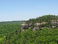
It is believed that Cumberland Falls originated at the Pottsville Escarpment, near modern-day Burnside, Kentucky, and retreated to its current location approximately 45 miles (72 km) upstream. In its retreat, the falls cut what is now the Cumberland River gorge, reaching depths in places of up to 400 feet (120 m). [1] :11 [2] At its original location, the falls was taller than it is currently, and has lost height due to erosion as it moved upstream. It also carried a greater volume of water originally, because two major tributaries, the Laurel River and the Rockcastle River, both lie between the modern day location and the escarpment. [1] :19 The erosion of the underlying rock, and movement of the falls downward in height, and upstream in location will continue until the falls eventually disappears, and the river again becomes smoothly graded. [1] :18–9

Pre-modern history

The area surrounding Cumberland Falls was inhabited by Native Americans going as far back as 10,000 years. [3] [4] :22 By 1650, the area had been visited by those from the Shawnee, Cherokee, Chickasaw, and the Creek peoples. The Cumberland, as well as the nearby Eagle Falls were both considered sacred by many. [3]

Modern history

In 1750 the Cumberland Falls was rediscovered by the explorer Thomas Walker who named it after the Duke of Cumberland and Strathearn. [4] :22 [lower-alpha 1] The first recorded landowners of the falls were Matthew Walton and Adam Shepard in 1800, both engineers who served under George Washington during the American Revolution. [4] :22 [5] :314 Walton and Shepard surveyed the land in 1814, and were issued a land patent in 1828. [5] :314

The first landowners to settle permanently at Cumberland Falls were Lewis Renfro, a Baptist minister, and his wife Mary, who built a cabin there in 1850, which would later be used as a hospital during the American Civil War. [lower-alpha 2] [lower-alpha 3] The falls and 400 acres of surrounding land were purchased in 1875 by Socrates Owens, who there built the Cumberland Hotel, which was taken over by his wife Nannie and his son Edward following his death. [3] The land and hotel were purchased in 1902 by Henry Brunson, who managed it along with his two daughters until 1931. [5] :314 [6] :103

Illustration of the falls from the King's Hand-book of the United States, 1891 US-KY(1891) p277 CUMBERLAND FALLS.jpg
Illustration of the falls from the King's Hand-book of the United States, 1891

In 1927 the Kiwanis Club sponsored a trail to be built from nearby Corbin, Kentucky, and dedicated to Kentucky governor William J. Fields. [5] :315 Construction occupied some 200 laborers over nine weeks. [4] :22 However, as late as 1929, the Izaak Walton League wrote of access to the falls saying:

The unspoiled charm of Cumberland Falls is due to the fact that the falls are difficult to reach ... Road maps show roads leading from Corbin, twenty miles to the northeast, and from Williamsburg, eighteen miles from the southeast, but both these are so rough as to be practicable only for saddle-horses. [7] [lower-alpha 4]

In 1928, a proposal to accept the falls as a park was brought to the floor of the Kentucky Senate but was defeated. [5] :315

In the late 1920s, there were plans to build a hydroelectric power station upstream, and divert the river through a mountain tunnel to a point below the falls. [5] :314–5 However, the Cumberland Falls Preservation Association, formed by businessman Rober Blair, convinced T. Coleman du Pont to purchase the falls and surrounding land, and stipulate they were never to be used for hydroelectricity. [8] :60 In 1930, following his death, the family of du Pont made the decision to donate the 539 acres (218 ha) to the state. [3] [6] :103–5 On March 10, 1930, the Kentucky House and Senate overrode the veto of Governor Flem D. Sampson, and voted to accept the land from the du Pont family. The park was officially opened on September 7, 1931. [5] :315

In the 1950s, plans were again announced for the development of upstream hydroelectric power, but were again defeated by the Preservation Association. [8] :60

In 2016, two men, Dane Jackson and Nicholas Troutman, were charged with misdemeanor trespassing after intentionally going over Cumberland Falls in kayaks. [9]

Moonbow

During or near a full moon on clear nights, a lunar rainbow or moonbow is sometimes formed by the water of the falls. [3] [10] :44 The formation of a moonbow at Cumberland Falls is aided by a combination of steep gorge walls, which reduce dissipation of the waterfall's mist by wind, and a wide gorge which allows increased levels of moonlight. [11]

It is the only location in the Western Hemisphere where moonbows are known to appear with regularity, [8] :60 [10] :44 [11] and the Kentucky Department of Parks publishes schedules for visitors. [lower-alpha 5] [lower-alpha 6]

The ability of visitors to see a moonbow may vary with water level. At low levels, the falls may not produce sufficient mist for the phenomenon. Conversely, if conditions include substantial downstream wind, this may increase the level of mist and make a moonbow more likely to be visible. [13]

Cumberland Falls moonbow Cumberland Falls Moonbow panarama.jpg
Cumberland Falls moonbow

Statistics

Highest and lowest water flow years (1908–2015) [14]
YearAverage
19275,196 ft3/s
19945,143 ft3/s
19745,117 ft3/s
20114,974 ft3/s
19734,684 ft3/s
YearAverage
19811,657 ft3/s
19311,622 ft3/s
19661,499 ft3/s
19411,423 ft3/s
19881,324 ft3/s

On average the falls, which flows over a resistant sandstone bed, is 68 feet (21 m) high and 125 feet (38 m) wide. [15] Cumberland Falls is the second largest waterfall east of the Rocky Mountains, and the largest waterfall as measured by water volume in the Eastern United States, south of Niagara Falls. [16] [17] The falls divides the river into two sections, the Upper and Lower, or "below the falls" section. [18]

Water flow

The water which flows through the Cumberland Falls gathers from a drainage area of 1,977 square miles (5,120 km2). [19] In data collected between 1908 and 2017 by the United States Geological Survey, peak annual water flow at the falls occurred in 1927, at an average rate of 5,196 ft3/s, and the all-time low occurred in 1988, during the 1988–89 North American drought, at an average rate of 1,324 ft3/s. [14] The all-time highest recorded water volume was on Jan. 28, 1918, at a rate of 59,600 ft3/s, and the lowest recorded annual peak water flow was on Feb. 02, 1985, at 17,500 ft3/s, but was partially due to water diversion. The lowest naturally occurring annual peak water flow was on Feb. 17, 1964, at 18,200 ft3/s. [20]

Film
Video Games

See also

Notes

  1. In his published papers Keen Johnson disputes this, saying that Walker and certain long hunters "evidently had been in the region," but that Matthew Walton and Adam Shepherd were the first to see the falls. [5] :314
  2. Ludwick and Thomas Hess record one Samuel Garland at the location prior to Lewis Refro. [4] :22 They do not include a definite date, but say he "intended to build a water mill but instead built a cabin where he resided." According to the official Kentucky Parks website, Garland built a "cabin in which he resided for a while before returning to Virginia." [3]
  3. The tract of land granted to the Renfros accounted for 200 acres (81 ha) and was valued at $1,000. [5] :314
  4. See also Williamsburg, Kentucky.
  5. As of 2017, schedules are published online at the Kentucky Department of Parks website. [12]
  6. Moonbows would previously regularly occur at Niagara Falls, but can no longer been due to high levels of light pollution. [11]

Related Research Articles

<span class="mw-page-title-main">Niagara River</span> River in New York, United States and Ontario, Canada

The Niagara River is a river that flows north from Lake Erie to Lake Ontario. It forms part of the border between the province of Ontario in Canada and the state of New York in the United States. There are differing theories as to the origin of the river's name. According to Iroquoian scholar Bruce Trigger, Niagara is derived from the name given to a branch of the locally residing native Neutral Confederacy, who are described as being called the Niagagarega people on several late-17th-century French maps of the area. According to George R. Stewart, it comes from the name of an Iroquois town called Ongniaahra, meaning "point of land cut in two".

<span class="mw-page-title-main">Niagara Falls</span> Waterfalls between United States and Canada

Niagara Falls is a group of three waterfalls at the southern end of Niagara Gorge, spanning the border between the province of Ontario in Canada and the state of New York in the United States. The largest of the three is Horseshoe Falls, which straddles the international border of the two countries. It is also known as the Canadian Falls. The smaller American Falls and Bridal Veil Falls lie within the United States. Bridal Veil Falls is separated from Horseshoe Falls by Goat Island and from American Falls by Luna Island, with both islands situated in New York.

<span class="mw-page-title-main">Horseshoe Falls</span> Largest portion of Niagara Falls on the United States–Canada border

Horseshoe Falls is the largest of the three waterfalls that collectively form Niagara Falls on the Niagara River along the Canada–United States border. Approximately 90% of the Niagara River, after diversions for hydropower generation, flows over Horseshoe Falls. The remaining 10% flows over American Falls and Bridal Veil Falls. It is located between Terrapin Point on Goat Island in the US state of New York, and Table Rock in the Canadian province of Ontario. These falls are also referred to as the Canadian Falls.

<span class="mw-page-title-main">Williamsburg, Kentucky</span> City in Kentucky, United States

Williamsburg is a home rule-class city in and the county seat of Whitley County, on the southeastern border of Kentucky, United States. The population was 5,326 at the 2020 census. Developed along the Cumberland River, the city was founded in 1818 and named after William Whitley.

<span class="mw-page-title-main">Moonbow</span> Rainbow produced by moonlight rather than sunlight

A moonbow is a rainbow produced by moonlight rather than direct sunlight. Other than the difference in the light source, its formation is the same as for a solar rainbow: It is caused by the refraction of light in many water droplets, such as a rain shower or a waterfall, and is always positioned in the opposite part of the sky from the Moon relative to the observer.

<span class="mw-page-title-main">Cumberland River</span> River in Kentucky and Tennessee, United States

The Cumberland River is a major waterway of the Southern United States. The 688-mile-long (1,107 km) river drains almost 18,000 square miles (47,000 km2) of southern Kentucky and north-central Tennessee. The river flows generally west from a source in the Appalachian Mountains to its confluence with the Ohio River near Paducah, Kentucky, and the mouth of the Tennessee River. Major tributaries include the Obey, Caney Fork, Stones, and Red Rivers.

<span class="mw-page-title-main">Rock River (Mississippi River tributary)</span> Tributary of the Mississippi River in the US

The Rock River is a tributary of the Mississippi River, approximately 299 miles (481 km) long, in the U.S. states of Wisconsin and Illinois. The river was known as the Sinnissippi to Sauk and Meskwaki peoples; the name means "rocky waters".

<span class="mw-page-title-main">Falling Water River</span> River in Tennessee, United States

The Falling Water River is a 46.8-mile-long (75.3 km) stream in the east-central portion of Middle Tennessee in the United States. It rises just west of Monterey at the edge of the Cumberland Plateau, and traverses the Eastern Highland Rim before dropping off to the Nashville Basin and emptying into Center Hill Lake along the Caney Fork. The river is noted for the 136-foot (41 m) Burgess Falls, which it spills over near the end of its course.

<span class="mw-page-title-main">Big South Fork of the Cumberland River</span> River in the United States

The Big South Fork of the Cumberland River is a 76-mile-long (122 km) river in the U.S. states of Tennessee and Kentucky. It is a major drainage feature of the Cumberland Plateau, a major tributary of the Cumberland River system, and the major feature of the Big South Fork National River and Recreation Area.

<span class="mw-page-title-main">Oak Orchard Creek</span> River in New York, United States

Oak Orchard Creek is a tributary of Lake Ontario in Orleans County, New York in the United States.

<span class="mw-page-title-main">Shoshone Falls</span> Waterfall on the Snake River, Idaho

Shoshone Falls is a waterfall in the western United States, on the Snake River in south-central Idaho, approximately three miles (5 km) northeast of the city of Twin Falls. Sometimes called the "Niagara of the West," Shoshone Falls is 212 feet (65 m) in height, 45 feet (14 m) higher than Niagara Falls, and flows over a rim nearly one thousand feet (300 m) in width.

<span class="mw-page-title-main">Niagara Gorge</span> Canyon on the border between New York, USA and Ontario, Canada

Niagara Gorge is an 11 km (6.8 mi) long canyon carved by the Niagara River along the Canada–United States border, between the U.S. state of New York and the Canadian province of Ontario. It begins at the base of Niagara Falls and ends downriver at the edge of the geological formation known as the Niagara Escarpment near Queenston, Ontario, where the falls originated about 12,500 years ago. The position of the falls has receded upstream toward Lake Erie because of the falling waters' slow erosion of the riverbed's hard Lockport dolomite, combined with rapid erosion of the relatively soft layers beneath it. This erosion has created the gorge.

<span class="mw-page-title-main">Ellicott Creek</span> River in New York, United States

Ellicott Creek is a stream in Western New York, United States. It is a tributary of Tonawanda Creek, which in turn flows into the Niagara River.

<span class="mw-page-title-main">Cumberland Falls State Resort Park</span> Park in Kentucky, United States

Cumberland Falls State Resort Park is a park located just southwest of Corbin, Kentucky, and is contained entirely within the Daniel Boone National Forest. The park encompasses 1,657 acres (671 ha) and is named for its major feature, 68-foot-tall (21 m) Cumberland Falls. The falls are one of the few places in the western hemisphere where a moonbow can frequently be seen on nights with a full moon. The park is also the home of 44-foot (13 m) Eagle Falls. The section of the Cumberland River that includes the falls was designated a Kentucky Wild River by the Kentucky General Assembly through the Office of Kentucky Nature Preserves' Wild Rivers System. The forest in the park is also a dedicated State Nature Preserve.

<span class="mw-page-title-main">Scott's Gulf</span> Canyon in Tennessee

Scott's Gulf is a canyon situated along the Caney Fork River in White County, Tennessee, in the southeastern United States. The canyon stretches for approximately 18 miles (29 km) as the Caney Fork drops from the top of the Cumberland Plateau down to the eastern Highland Rim. This remote section of the river is home to a wilderness area consisting of a largely undisturbed deciduous forest, numerous waterfalls, caves and other geological formations, and Class IV and Class V whitewater rapids.

<span class="mw-page-title-main">Havasu Creek</span> Stream in Arizona, United States of America

Havasu Creek is a stream in the U.S. state of Arizona associated with the Havasupai people. It is a tributary to the Colorado River, which it enters in the Grand Canyon.

<span class="mw-page-title-main">Waterfalls in Ricketts Glen State Park</span> Waterfalls in Ricketts Glen State Park in the U.S. state of Pennsylvania

There are 24 named waterfalls in Ricketts Glen State Park in the U.S. state of Pennsylvania along Kitchen Creek as it flows in three steep, narrow valleys, or glens. They range in height from 9 feet (2.7 m) to the 94-foot (29 m) Ganoga Falls. Ricketts Glen State Park is named for R. Bruce Ricketts, a colonel in the American Civil War who owned over 80,000 acres in the area in the late 19th and early 20th centuries, but spared the old-growth forests in the glens from clearcutting. The park, which opened in 1944, is administered by the Bureau of State Parks of the Pennsylvania Department of Conservation and Natural Resources (DCNR). Nearly all of the waterfalls are visible from the Falls Trail, which Ricketts had built from 1889 to 1893 and which the state park rebuilt in the 1940s and late 1990s. The Falls Trail has been called "the most magnificent hike in the state" and one of "the top hikes in the East".

<span class="mw-page-title-main">Poesten Kill</span> River in New York, United States

The Poesten Kill is a 26.2-mile-long (42.2 km) creek in upstate New York located entirely in Rensselaer County, which flows westerly from its source at Dyken Pond in the town of Berlin to its mouth at the Hudson River in the city of Troy. The creek has historically been used as a source of water for the local inhabitants and farmers. During the Industrial Revolution, it became an important source of water power, and many mills and factories sprung up along its banks.

<span class="mw-page-title-main">Niagara Whirlpool</span> Natural whirlpool in the Niagara Gorge, downstream from Niagara Falls

The Niagara Whirlpool is a natural whirlpool within the Niagara River located along the Canada–U.S. border between New York and Ontario. The whirlpool is in the Niagara Gorge, downstream from Niagara Falls. The whirlpool's greatest depth is 125 feet (38 m).

References

  1. 1 2 3 McGrain, Preston (1955). "Geology of the Cumberland Falls State Park Area" (PDF). Kentucky Geological Survey. Retrieved 5 November 2017.
  2. Kleber, John E. (Jan 13, 2015). The Kentucky Encyclopedia. University Press of Kentucky. ISBN   9780813117720 . Retrieved 5 November 2017.
  3. 1 2 3 4 5 6 "Cumberland Falls History". Kentucky State Parks. Retrieved 6 November 2017.
  4. 1 2 3 4 5 Ludwick, Cameron M.; Thomas Hess, Blair (2015). My Old Kentucky Road Trip: Historic Destinations & Natural Wonders. Arcadia Publishing. ISBN   9781626198166 . Retrieved 6 November 2017.
  5. 1 2 3 4 5 6 7 8 9 Johnson, Keen (1982). The Public Papers of Governor Keen Johnson, 1939-1943. University Press of Kentucky. ISBN   9780813106052 . Retrieved 6 November 2017.
  6. 1 2 Manning, Russ (1999). The Historic Cumberland Plateau: An Explorer's Guide. University of Tennessee Press. ISBN   9781572330443 . Retrieved 5 November 2017.
  7. Outdoor America, Volume 8. Izaak Walton League of America. 1929. p. 23. Retrieved 6 November 2017.
  8. 1 2 3 Palmer, Tim (2004). Endangered Rivers and the Conservation Movement . Rowman & Littlefield. ISBN   9780742531413 . Retrieved 5 November 2017.
  9. Estep, Bill (March 14, 2016). "Two charged after going over Cumberland Falls in kayaks". Lexington Herald-Leader . Archived from the original on 7 November 2017. Retrieved 6 November 2017.
  10. 1 2 Klotter, James (September 12, 2010). A Concise History of Kentucky. University Press of Kentucky. ISBN   9780813124988 . Retrieved 6 November 2017.
  11. 1 2 3 Koontz, Katy. "Where to find the rare white rainbow". BBC . Retrieved 6 November 2017.
  12. "Cumberland Falls". Kentucky Department of Parks. Retrieved 5 November 2017.
  13. Preston, McGrain (1983). "The Geologic Story of Kentucky" (PDF). Kentucky Geological Survey. p. 30. Archived from the original (PDF) on 4 March 2016. Retrieved 6 November 2017.
  14. 1 2 "USGS Surface-Water Annual Statistics for the Nation, USGS 03404500". United States Geological Survey . Retrieved 5 November 2017.
  15. Kentucky Society of Natural History Archived 2011-07-27 at the Wayback Machine Retrieved May 29, 2010
  16. "The Explore Kentucky Must List: Waterfalls (Pt 2)". explorekentucky.us. Archived from the original on 7 November 2017. Retrieved 6 November 2017.
  17. "Cumberland Falls Area Trails" (PDF). United States Department of Agriculture . Archived from the original (PDF) on 7 November 2017. Retrieved 6 November 2017.
  18. "Cumberland River - Stearns". US Department of Agriculture . Retrieved 6 November 2017.
  19. "Peak Streamflow for the Nation USGS 03404500". United States Geological Survey . Retrieved 5 November 2017.
  20. "Peak Streamflow for the Nation USGS 03404500". United States Geological Survey . Retrieved 5 November 2017.
  21. 1 2 3 4 Thompson, George E. (2009). You Live Where?: Interesting and Unusual Facts about where We Live. iUniverse. p. 219. ISBN   9781440134210 . Retrieved 6 November 2017.
  22. Burton, K. Melissa (2014-01-28). "On Location". Kentucky Monthly . Retrieved 6 November 2017.
  23. 1 2 Shockley, Jenn (July 2016). "This Unbelievable Kentucky Waterfall Is Hiding In Plain Sight… No Hiking Required". Only in Your State. Retrieved 6 November 2017.
  24. Lee, Michael (3 March 2021). "Red Dead Redemption 2 Player Shows Real-World Inspiration For Gorgeous In-Game Area". Gamerant. Retrieved 20 July 2022.