Natural Bridge State Resort Park

Last updated

Natural Bridge State Resort Park
Natural Bridge KY-27527-3.jpg
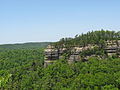
Natural Bridge as viewed from Lookout Point
Location Powell County & Wolfe County, Kentucky, United States
Nearest city Stanton, Kentucky
Coordinates 37°46′39″N83°41′37″W / 37.77750°N 83.69361°W / 37.77750; -83.69361
Area2,250 acres (910 ha)
Established1926
Governing bodyKentucky Department of Parks
parks.ky.gov/parks/resortparks/natural-bridge/

Natural Bridge State Resort Park is a Kentucky state park located in Powell and Wolfe Counties along the Middle Fork of the Red River, adjacent to the Red River Gorge Geologic Area and surrounded by the Daniel Boone National Forest. Its namesake natural bridge is the centerpiece of the park. The natural sandstone arch spans 78 ft (24 m) and is 65 ft (20 m) high. The natural process of weathering formed the arch over millions of years. The park is approximately 2,300 acres (9 km2) of which approximately 1,200 acres (5 km2) is dedicated by the Office of Kentucky Nature Preserves as a nature preserve. In 1981 this land was dedicated into the nature preserves system to protect the ecological communities and rare species habitat. The first federally endangered Virginia big eared bats, Corynorhinus townsendii virginianus , recorded in Kentucky were found at Natural Bridge State Resort Park in the 1950s.

Contents

History and trails

The park was founded as a private tourist attraction in 1895 by the Lexington and Eastern Railroad. In 1910, Louisville and Nashville Railroad acquired the land when it purchased the Lexington and Eastern Railroad. In 1926, L&N's President Wible L. Mapother turned over its approximately 137 acres to the Kentucky State Park Commission, [1] making the Park one of Kentucky's original four state parks when that system was established the same year. There are over 20 miles (32 km) of trails over uneven terrain from moderate to strenuous difficulty, including trails to White's Branch Arch, Henson's Cave Arch, and other scenic areas. Some of the most famous sites are the arch itself, "Lovers Leap", and "Fat Man's Squeeze". The park's 0.5-mile (0.8 km) "Original Trail" to the natural bridge dates from the 1890s. Other trails include the 7.5-mile (12.1 km) Sand Gap Trail and the 0.75-mile (1.21 km) Balanced Rock Trail. Five miles (8 km) of the 307-mile (494 km) Sheltowee Trace National Recreation Trail run through the park, including the Whittleton Trail which connects the park to the Red River Gorge Geologic Area. Activities such as hiking off-trails, disturbing wildlife, or collecting plants are not legal in any Kentucky State Park, and pets are not allowed on most trails at Natural Bridge State Park. [2] "Fat Man's Squeeze", a narrow passage in the rock formation, leads to the bottom of the arch. In addition to these trails, a paid ski lift attraction is available to take people to the top of the Natural Bridge.

Natural Bridge has several unique sandstone rock formations, including the Balanced Rock. This is a huge block of sandstone balanced on the edge of a cliff near the Natural Bridge. The "Balanced Rock", is located on Trail #2, not far above Hemlock Lodge. In the early days of the Park, it was called the Sphinx because, when viewed from the correct angle, it crudely resembles the Sphinx in Egypt. Although it is now called the Balanced Rock, it is in fact a pedestal rock - a single piece of stone that has weathered in such a fashion that its midsection is narrower than its cap or its base. This formation is one of the biggest and most perfectly formed examples of a pedestal rock east of the Rocky Mountains.[ citation needed ]

Annual events

Natural Bridge State Park is a member of the Leave No Trace Center for Outdoor Ethics, and offers guided backpacking trips and natural history educational programs. Annual events open to the public include Herpetology Weekend each May, Natural Arches Weekend each February, and the Kentucky Native Plant Society's Wildflower Weekend each April.

The Kentucky Natives Society's Wildflower Weekend in April consists of Kentucky plants and how they are essential to the well-being of our natural ecosystems commonwealth. " We incorporate research and support efforts to identify and protect endangered, threatened, and rare native plant species," says KNPS.ORG.

The State Park is also famous for hosting traditional Appalachian square dances. The traditional Appalachian style dances are held on Friday and Saturday evenings throughout the warm starlit Ky summers on the open-air dance floor. The dance draws hundreds of participants and spectators, showcasing dance groups and singer/performer talents from all over.

See also

Related Research Articles

<span class="mw-page-title-main">Red River Gorge</span> Protected natural area in Kentucky, United States

The Red River Gorge is a canyon system on the Red River in east-central Kentucky. Geologically it is part of the Pottsville Escarpment.

<span class="mw-page-title-main">Natural arch</span> Arch-shaped natural rock formation

A natural arch, natural bridge, or rock arch is a natural landform where an arch has formed with an opening underneath. Natural arches commonly form where inland cliffs, coastal cliffs, fins or stacks are subject to erosion from the sea, rivers or weathering.

<span class="mw-page-title-main">Balanced Rock</span> Rock formation in Arches National Park

Balanced Rock is one of the most popular features of Arches National Park, situated in Grand County, Utah, United States. Balanced Rock is located next to the park's main road, at about 9.2 miles (14.8 km) from the park entrance. It is one of only a few prominent features clearly visible from the road. The total height of Balanced Rock is 128 feet, with the balancing rock rising 55 feet above the base. This rock is the largest of its kind in the park, weighing approximately 3,577 tons.

<span class="mw-page-title-main">Turkey Run State Park</span> State park and historic place in Indiana, U.S.

Turkey Run State Park, Indiana's second state park, is in Parke County in the west-central part of the state along State Road 47, 2 miles (3.2 km) east of U.S. 41.

<span class="mw-page-title-main">Natchez Trace Parkway</span> National parkway in the southeastern U.S.

The Natchez Trace Parkway is a national parkway in the Southeastern United States that commemorates the historic Natchez Trace and preserves sections of that original trail. Its central feature is a two-lane road that extends 444 miles (715 km) from Natchez, Mississippi, to Nashville, Tennessee. Access to the parkway is limited, with more than 50 access points in Mississippi, Alabama, and Tennessee. The southern end of the route is in Natchez at its intersection with Liberty Road, and the northern end is northeast of Fairview, Tennessee, in the suburban community of Pasquo, at an intersection with Tennessee State Route 100. In addition to Natchez and Nashville, larger cities along the route include Jackson and Tupelo, Mississippi, and Florence, Alabama.

<span class="mw-page-title-main">Rockbridge State Nature Preserve</span> Protected area in Ohio, United States

Rockbridge State Nature Preserve is a nature reserve featuring a natural bridge located in the unincorporated community of Rockbridge in Hocking County, Ohio, United States. It is part of the Hocking Hills region, but the sandstone that forms the natural bridge is located lower in the stratigraphic sequence than that which forms most of the region's notable features.

<span class="mw-page-title-main">Louisville and Nashville Railroad</span> Defunct American Class I railway

The Louisville and Nashville Railroad, commonly called the L&N, was a Class I railroad that operated freight and passenger services in the southeast United States.

<span class="mw-page-title-main">Sheltowee Trace Trail</span>

The Sheltowee Trace Trail is a 343-mile (552.00 km) National Recreation Trail that was created in 1979 and stretches from the Burnt Mill Bridge Trail Head in the Big South Fork National River and Recreation Area in Tennessee to northern Rowan County, Kentucky. The trail is named after Daniel Boone, who was given the name Sheltowee when he was adopted as the son of the great warrior Chief Blackfish of the Shawnee tribe.

<span class="mw-page-title-main">Arch Creek, Florida</span> Historic site in the U.S. state of Florida

Arch Creek was an early settlement in Miami-Dade County, Florida, in present-day metropolitan Miami. Tequesta Indians thrived here before the first Europeans arrived in the early 16th century. The name is derived from the 40 feet (12 m) long natural limestone bridge that spanned the creek until 1973. It is part of the Arch Creek Memorial Park at 1855 Northeast 135th Street, on Biscayne Boulevard. It was added to the U.S. National Register of Historic Places on July 15, 1986.

<span class="mw-page-title-main">Big South Fork National River and Recreation Area</span> Protected area in central northeast Tennessee and southeastern Kentucky, United States

The Big South Fork National River and Recreation Area, commonly known as Big South Fork, preserves the Big South Fork of the Cumberland River and its tributaries in northeastern Tennessee and southeastern Kentucky.

Kingdom Come State Park is a part of Kentucky's state park system in Harlan County atop Pine Mountain near the city of Cumberland. It was named after the 1903 best-selling novel The Little Shepherd of Kingdom Come by native Kentuckian John Fox, Jr. Features of the park include Raven Rock, Log Rock, and a 3.5-acre (1.4 ha) mountain lake. The section of the park is also a legally dedicated state nature preserve by the Office of Kentucky Nature Preserves.

<span class="mw-page-title-main">Carter Caves State Resort Park</span> State park in Kentucky, USA

Carter Caves State Resort Park is located in Carter County, Kentucky, United States, along Tygarts Creek. It is formed by Carter Caves, and nearby Cascade Caves, which were added to the park in 1959. On December 16, 1981, 146 acres (59 ha) of the park were designated as nature preserves. Bat Cave and Cascade Caverns State Nature Preserves were dedicated for the protection of the Indiana bat, mountain maple, and Canada yew, all endangered species.

<span class="mw-page-title-main">Bad Branch Falls State Nature Preserve</span>

Bad Branch Falls State Nature Preserve is a forested gorge covering 2,639 acres near Whitesburg, KY in Letcher County, Kentucky. The deep and narrow gorge, adjacent to the Jefferson National Forest is carved into the face of Pine Mountain. Sandstone boulders and cliffs along with riglines and knobs provide views into the Appalachia area. The terrain is landscaped with streams, rivers, and a 60-foot waterfall. With a variety of habitat types, this nature preserve is home to many unique and unknown species of flora and fauna.

Lake Malone State Park is a 338-acre (137 ha) state park located near Dunmor, Kentucky, in Muhlenberg County and extending into parts of Logan County and Todd County. In addition to the 788-acre (319 ha) Lake Malone, the natural features of the park include sandstone cliffs and a natural rock bridge.

<span class="mw-page-title-main">White Pines Forest State Park</span> State park in Illinois, US

White Pines Forest State Park, more commonly referred to as White Pines State Park, is an Illinois state park in Ogle County, Illinois. It is located near the communities of Polo, Mount Morris and Oregon. The 385-acre (156 ha) park contains the southernmost remaining stand of native white pine trees in the state of Illinois, and that area, 43 acres (17 ha), was designated an Illinois Nature Preserve in 2001.

<span class="mw-page-title-main">Cumberland Falls State Resort Park</span> Park in Kentucky, United States

Cumberland Falls State Resort Park is a park located just southwest of Corbin, Kentucky, and is contained entirely within the Daniel Boone National Forest. The park encompasses 1,657 acres (671 ha) and is named for its major feature, 68-foot-tall (21 m) Cumberland Falls. The falls are one of the few places in the western hemisphere where a moonbow can frequently be seen on nights with a full moon. The park is also the home of 44-foot (13 m) Eagle Falls. The section of the Cumberland River that includes the falls was designated a Kentucky Wild River by the Kentucky General Assembly through the Office of Kentucky Nature Preserves' Wild Rivers System. The forest in the park is also a dedicated State Nature Preserve.

The Louisville and Nashville Turnpike was a toll road that ran from Louisville, Kentucky to Nashville, Tennessee during the 19th century. From Louisville, one route now designated US 31W ran through Elizabethtown, Munfordville, Glasgow Junction, Bowling Green, and Franklin before crossing into Tennessee. In Tennessee, the route would continue through Portland, Cross Plains, Millersville and Goodlettsville before going into Nashville. The other route ran through Bardstown, Buffalo, Glasgow, and Scottsville and is currently named US 31E. The name survives in abbreviated form along routes including Kentucky State Routes 335 and 470. US 31W is usually named for the Dixie Highway which succeeded the Turnpike.

<span class="mw-page-title-main">Beargrass Creek State Nature Preserve</span> Nature preserve in Kentucky, United States

Beargrass Creek State Nature Preserve is a 41-acre (17 ha) nature preserve located in Louisville, Kentucky's Poplar Level neighborhood, in roughly the central portion of the city. It is named for Beargrass Creek, the south fork of which passes along the northern side of the preserve. The preserve is adjacent to Louisville's Joe Creason Park and the Louisville Nature Center. It is owned by the Office of Kentucky Nature Preserves and the LNC assists with management.

<span class="mw-page-title-main">Arches National Park</span> National park in Utah, United States

Arches National Park is a national park in eastern Utah, United States. The park is adjacent to the Colorado River, 4 mi (6 km) north of Moab, Utah. More than 2,000 natural sandstone arches are located in the park, including the well-known Delicate Arch, as well as a variety of unique geological resources and formations. The park contains the highest density of natural arches in the world.

<span class="mw-page-title-main">Balancing rock</span> Naturally occurring precariously balanced rock

A balancing rock, also called a balanced rock or precarious boulder, is a naturally occurring geological formation featuring a large rock or boulder, sometimes of substantial size, resting on other rocks, bedrock, or on glacial till. Some formations known by this name only appear to be balancing, but are in fact firmly connected to a base rock by a pedestal or stem.

References

  1. "Louisville & Nashville Employes' Magazine :: Louisville and Nashville Railroad Company Records". digital.library.louisville.edu. Retrieved February 14, 2017.
  2. "Natural Bridge State Resort Park".