Bad Branch Falls State Nature Preserve

Last updated
Bad Branch Falls State Nature Preserve
Bad Branch Falls in Kentucky.jpg
Bad Branch Falls
USA Kentucky location map.svg
Red pog.svg
Map of Kentucky
Location Letcher County, Kentucky, United States
Nearest city Cumberland, Kentucky
Coordinates 37°04′03″N82°46′20″W / 37.0675°N 82.7721°W / 37.0675; -82.7721 Coordinates: 37°04′03″N82°46′20″W / 37.0675°N 82.7721°W / 37.0675; -82.7721
Area2,639 acres (1,068 ha)
EstablishedSeptember 26, 1985
Official website

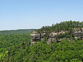
Bad Branch Falls State Nature Preserve is a forested gorge covering 2,639 acres (10.68 Km2) near Whitesburg, KY in Letcher County, Kentucky. The deep and narrow gorge, adjacent to the Jefferson National Forest is carved into the face of Pine Mountain. Sandstone boulders and cliffs along with riglines and knobs provide views into the Appalachia area. The terrain is landscaped with streams, rivers, and a 60-foot waterfall. With a variety of habitat types, this nature preserve is home to many unique and unknown species of flora and fauna. [1]

Contents

History

The Nature Conservatory (TNC) sold the original 435 acres (1.76 km2) of Bad Branch Gorge to the Kentucky State Nature Preserves (KSNPC) in 1985, and by making that agreement, TNC and KSNPC became co-owners of Bad Branch Falls State Nature Preserve. [1] On September 26, 1985, the sold area, which included a 60-foot waterfall feature, was dedicated a nature preserve by the Office of Kentucky State Nature Preserves. [2] Later in 1986, Bad Branch was considered part of the Kentucky State Wild River System. In 1900, 1,031 acres of land containing part of the upper watershed was purchased by TNC. The new 1,031 acres of land was bought by a $500,000 donation made possible by Mary and Barry Bingham Sr. Fund. An additional 820 acres were acquired by the KSNPC in 1997. Other surrounding lots of land, totaling to about 900 acres, have been designated and protected by landowner agreements or through the registry. [1] Today, Bad Branch Falls is a 2,639-acre State Nature Preserve covering a section of the Presley House Branch watershed, a part of the northern face of Pine Mountain, and the upper region of the Bad Branch watershed. [2]

Biology and ecology

Amounting to more than 30 different species, Bad Branch Falls State Nature Preserve is considered to protect one of the largest concentrations of rare species of flora and fauna in the state of Kentucky. [1] The preserve is also home to two nesting common ravens (Corvus corax), which are the only known pair in the state of Kentucky. Upon visiting, the trails and foot bridges will take visitors through a hemlock-mixed mesophytic forest. [1] Tulip poplar, sweet birch, yellow birch, basswood, buckeye and American beech also grow alongside the hemlock species. Beneath the upper canopy of trees are the umbrella magnolia, sweet pepperbush, flowering dogwood, and rosebay rhododendron. The Nature Conservatory and the Office of Kentucky Nature Preserves are working together with the Kentucky Natural Lands Trust, Kentucky Department of Fish and Wildlife Resources, U.S. Fish and Wildlife Service to protect the forest against the infestation of the non-native insect pest, hemlock wooly adelgid. [1] The gorge creates the right conditions for a number of rare species that thrive in shaded, moist areas. Some of these species include the small enchanter's nightshade, Fraser's sedge, painted trillium, longtail shrew and the federally-rare blackside dace. [1] Animals Including Black Bears and Cumberland Arrow Darte can also be spotted passing through the preserve. [1]

Recreation

Bad Branch Falls State Nature Preserve has an uneven terrain resulting in about 7 miles of strenuous hiking trails and foot bridges throughout the nature preserve. The moderate 1.8 mile loop leading Bad Branch Gorge where the 60-foot waterfall flows over the sandstone cliffs, starts from a small parking lot that can hold up to 10 cars and one bus. The upper portion of the preserves has a roughly 3 mile, one-way trail that makes its way High Rock and Ran Polly Gap. At the northern terminus of the 6 mile trail loop connects to the 42-mile long Pine Mountain State Scenic Trail. The Office of Kentucky Nature Preserves has a brochure including the trail maps available to download on their website. [2] According to The Nature Conservatory, the Trail system is well maintained and developed. [1] In the yearly annual report conducted by the Office of Kentucky Nature Preserves, they record new foot bridges were put in place by volunteers in 2020 in order to make the preserve more accessible. [2] Even with the additional foot bridges, hazardous signs to hike this trail are put in place due to the steep grades formed by the geological feature called a thrust-fault. [3]

Related Research Articles

Red River Gorge Protected natural area in Kentucky, United States

The Red River Gorge is a canyon system on the Red River in east-central Kentucky. Geologically, it is part of the Pottsville Escarpment.

Hocking Hills State Park State park in Ohio, United States

Hocking Hills State Park is a state park in the Hocking Hills region of Hocking County, Ohio, United States. In some areas the park adjoins the Hocking State Forest. Within the park are over 25 miles (40 km) of hiking trails, rock formations, waterfalls, and recess caves. The trails are open from dawn to dusk, all year round, including holidays.

Sams Point Preserve

Sam's Point Preserve, or Sam's Point Dwarf Pine Ridge Preserve, is a 4,600-acre (19 km2) preserve in Ulster County on the highest point of the Shawangunk Ridge in New York, on the Wawarsing, New York-Shawangunk town line. It is owned and managed by the New York State Office of Parks, Recreation and Historic Preservation after having previously been managed by The Nature Conservancy. Its unique environment features dwarf pitch pine trees along the ridgetop. Located within the park is Lake Maratanza, the highest lake on the ridge, and the Ellenville Fault Ice Caves.

Taughannock Falls State Park State park in New York state, United States

Taughannock Falls State Park is a 750-acre (3.0 km2) state park located in the town of Ulysses in Tompkins County, New York in the United States. The park is northwest of Ithaca near Trumansburg.

Bash Bish Falls State Park

Bash Bish Falls State Park is a Massachusetts state park located in the town of Mount Washington. The park is named after Bash Bish Falls, Massachusetts' highest single-drop waterfall, which lies within its borders. The park is managed by the Department of Conservation and Recreation and is one of several nature preserves in the extreme southwestern corner of Massachusetts noted for their scenery. It is adjacent to the 4,000-acre (1,600 ha) Mount Washington State Forest, as well as New York's 5,000-acre (2,000 ha) Taconic State Park.

Natural Bridge State Resort Park State park in Kentucky, United States

Natural Bridge State Resort Park is a Kentucky state park located in Powell and Wolfe Counties along the Middle Fork of the Red River, adjacent to the Red River Gorge Geologic Area and surrounded by the Daniel Boone National Forest. Its namesake natural bridge is the centerpiece of the park. The natural sandstone arch spans 78 ft (24 m) and is 65 ft (20 m) high. The natural process of weathering formed the arch over millions of years. The park is approximately 2,300 acres (9 km2) of which approximately 1,200 acres (5 km2) is dedicated by the Office of Kentucky Nature Preserves as a nature preserve. In 1981 this land was dedicated into the nature preserves system to protect the ecological communities and rare species habitat. The first federally endangered Virginia big eared bats, Corynorhinus townsendii virginianus, recorded in Kentucky were found at Natural Bridge State Resort Park in the 1950s.

Chimney Rock State Park State park in North Carolina, United States

Chimney Rock State Park is a North Carolina state park in Chimney Rock, Rutherford County, North Carolina in the United States. The 8,014-acre (32.43 km2) park is located 25 miles (40 km) southeast of Asheville, North Carolina, and is owned and managed by the state of North Carolina.

Difficult Run

Difficult Run is a 15.9-mile-long (25.6 km) tributary stream of the Potomac River in Northern Virginia in the United States. The area has had many historical uses dating back to the early 1800s. Today, the area is used recreationally by visitors interested in the watershed's variety of options including hiking, biking, fishing, boating, climbing, and bird watching. The wildlife at Difficult Run is vast as 163 different species can be seen depending on the season. There are 41 different soil types found on the trail and alongside the stream. The stream is part of the greater 57.7- square-mile Drainage basin, or watershed, located in the north-central portion of Fairfax County and drains directly to the Potomac River.

Salt Springs State Park

Salt Springs State Park is a Pennsylvania state park in Franklin Township, Susquehanna County, Pennsylvania, in the United States. The park is home to massive hemlock trees that are over 500 years old and are among the largest trees in all of Pennsylvania. The Fall Brook Natural Area within the park is recognized as a part of the Old-Growth Forest Network. The park also features a gorge with three waterfalls on Fall Brook. Salt Springs State Park is 7 miles (11 km) north of Montrose, just off Pennsylvania Route 29. The park is the only state park in Pennsylvania that is managed by a non-profit organization, the Friends of Salt Springs Park. The state owns 405 acres (164 ha) of land and the Friends own an additional 437 acres (177 ha) bringing the total amount of protected land to 842 acres (341 ha).

Cumberland Falls State Resort Park

Cumberland Falls State Resort Park is a park located just southwest of Corbin, Kentucky and is contained entirely within the Daniel Boone National Forest. The park encompasses 1,657 acres (671 ha) and is named for its major feature, 68-foot-tall (21 m) Cumberland Falls. The falls are one of the few places in the western hemisphere where a moonbow can frequently be seen on nights with a full moon. The park is also the home of 44-foot (13 m) Eagle Falls. The section of the Cumberland River that includes the falls was designated a Kentucky Wild River by the Kentucky General Assembly through the Office of Kentucky Nature Preserves' Wild Rivers System. The forest in the park is also a dedicated State Nature Preserve.

Zoar Valley

Zoar Valley is an area of deep gorges along the Main and South branches of Cattaraugus Creek in western New York, United States. The valley is located along the border of Erie County and Cattaraugus County, roughly between the villages of Gowanda to the west and Springville to the east.

Bears Den Nature reserve in New Salem, Massachusetts

Bear's Den is a 6-acre (24,000 m2) nature reserve in New Salem, Massachusetts. The reservation is close to the Quabbin Reservoir and is owned by the Trustees of Reservations.

Conserving Carolina is a non-profit conservation organization working to preserve water and land resources in Western North Carolina. Conserving Carolina was created in July 2017, from a merger of two previously-separate organizations, Carolina Mountain Land Conservancy and Pacolet Area Conservancy. The combined organization maintains a primary office in Hendersonville, NC and a regional office in Columbus, NC.

Mianus River Gorge

The Mianus River Gorge is a 935-acre (3.78 km2) nature preserve in Bedford, New York jointly owned by The Nature Conservancy and Mianus River Gorge, Inc.. The first 60 acres (0.24 km2) were purchased by the Preserve, with help from the Conservancy, their first land preservation deal. It has grown over the years and is still managed by Mianus River Gorge, Inc. In March 1964, it was designated a National Natural Landmark for its old growth climax hemlock forest and the gorge of the Mianus River.

Thompson Pond

Thompson Pond in Pine Plains, New York is a 75-acre (30 ha) 15,000-year-old glacial kettle pond at the foot of 1,403-foot (428 m) Stissing Mountain. It is the source of Wappinger Creek, a tributary of the Hudson River that drains much of Dutchess County.

Plotter Kill Preserve

The Almy D. Coggleshall Plotter Kill Preserve is a 632-acre (256 ha) nature reserve and hiking area located on Route 159 in the town of Rotterdam, Schenectady County, New York State.

Aiken Canyon Preserve

Aiken Canyon Preserve is a 1,621-acre (6.56 km2) Nature Conservancy-managed state property in Colorado. It was first observed and named after Charles Aiken who was a 19th century U.S. surveyor, pioneer, and ornithologist who first surveyed Aiken Canyon in the 1870s and identified more than 75 bird species. The preserve consists of foothills, shrub and woodland ecosystems and is 12.4 miles southeast from Colorado Springs located on the eastern slope of the Rampart Range which is within a smaller foothill system of the Front Range. The surrounding mountain ranges of the Rampart Range and Palmer Divide created the nature preserves sustainable ecosystem. There is also a four-mile (6 km)-loop hiking trail on the preserve.

Fiery Gizzard Trail Trail in eastern Tennessee, United States

The Fiery Gizzard Trail runs from Tracy City, Tennessee to Foster Falls in Marion County, Tennessee. It is renowned for its beauty and diversity, cited by Backpacker magazine as one of the top 25 hiking trails in the United States. The 12.5-mile (20.1 km) trail offers scenic views, waterfalls, rock formations, and hemlock trees over 200 years old.

Kings River (Arkansas)

The Kings River is a tributary of the White River. It rises in the Boston Mountains of Arkansas and flows northward for more than 90 miles into Table Rock Lake in Missouri. The Arkansas portion of the river is undammed and bordered by rural and forested land, the river is popular for paddling and sport fishing.

Lula Lake Land Trust Land trust near Lookout Mountain, Georgia, US

Lula Lake Land Trust is an 8,000 acre land trust that includes Lula Lake and Lula Falls in the area around Lookout Mountain, Georgia outside Chattanooga, Tennessee. The area includes hiking trails and viewpoints. The property is accessible on set days at 5000 Lula Lake Road. Changes to Open Gate Day operations and access were made in 2019 including an online reservation system and a $15 per car fee. To make a reservation, visit https://www.lulalake.org/events.html

References

  1. 1 2 3 4 5 6 7 8 9 “Visit Bad Branch Nature Preserve.” The Nature Conservancy, www.nature.org/en-us/get-involved/how-to-help/places-we-protect/bad-branch-state-nature-preserve/?tab_q=tab_container-tab_element. Accessed 14 June 2021. This website is run by The Nature Conservancy, who is a co-owner of the Bad Branch Falls State Nature Preserve. Their website provides detailed information about the nature preserve, which is helpful for a successful and safe trip to the park. There are many rare species of plants and animals within Bad Branch Falls State Nature Preserve, and this source describes a few to help know what to look out for and to enrich a visit to the nature preserve.
  2. 1 2 3 4 “Bad Branch State Nature Preserve - Kentucky Energy and Environment Cabinet.” Ky.gov, 2019, eec.ky.gov/Nature-Preserves/Locations/Pages/Bad-Branch.aspx. Accessed 14 June 2021. This source is the official website created by the Commonwealth of Kentucky. The information found on the Bad Branch Falls State Nature Preserve page outlines the details and features of the area. Whenever venturing into the wilderness it is important to know what to prepare for, and this source gives an understanding of the preserve and all that it entails.
  3. "Bad Branch Falls and High Rock". High Lonesome Trails. This source is a secondary journal article that contains an opinion piece about the Bad Branch Trail. Trail conditions and what you should expect when hiking is discussed as well. This article would be helpful to read if you plan on hiking the Bad Branch Trail. Archived from the original on 2020-10-20. Retrieved 29 June 2021.{{cite web}}: CS1 maint: others (link)