Pound Gap

Last updated
Pound Gap
US23 cut at Pound Gap.jpg
Looking into the gap from the east
Elevation 2,392 ft (729 m)
Traversed byUS 23.svg US 23
Location Letcher County, Kentucky /
Wise County, Virginia,
United States
Range Cumberland Mountains
Coordinates 37°09′17″N82°37′58″W / 37.1548257°N 82.6326561°W / 37.1548257; -82.6326561

The Pound Gap of Pine Mountain is on the Virginia/Kentucky border between Jenkins, Kentucky and Pound, Virginia. It served as a passage for early settlers to cross into Kentucky from Virginia. Today, U.S. Route 23 passes through the gap. [1]

Contents

History

In 1750, early surveyors for the Ohio Company, possibly including Christopher Gist, passed through the gap. Many hunters used the gap to cross into Kentucky from Virginia for the next ten years. [2] In 1774, Daniel Boone used the gap to cross into Kentucky, along with Michael Stoner, to warn the land surveyors of a possible attack from the Shawnee Indians. Boone referred to Pound Gap as "Sounding Gap". [3] Circa 1800, some the first pioneer families of eastern Kentucky came to Kentucky through Pound Gap. [4] In Letcher County today are hundreds of the descendants of these pioneers. It was seven families who first came here around 1798: the Adamses, the Webbs, the Caudills, the Crafts, the Hammonds, the Sturgills, and the Collinses. The Hoggs, Maggards, Wrights, Fraziers, Fieldses, Bates, Halls, Bentleys, and Hamptons followed closely after the first settlement. [5]

In 1834, the General Assembly of Kentucky passed an act to improve the road (one of "Kentucky's Wilderness Traces") from Mount Sterling to Pound Gap to make travel to western Virginia more accessible. The route was widely used to drive livestock (horses, hogs and cattle) into Virginia and other southern markets and was shorter than other routes. [6] The Mount Sterling - Pound Gap road was considered "the longest pre-Civil War state road" [7] The route roughly follows modern day KY 11 from Mount Sterling to Clay City, then KY 15 from Clay City to Whitesburg, and finally US 119 from Whitesburg, along the Kentucky River, to its headwaters in Pound Gap.

In 1861 the Confederate States Army regiment under the command of Colonel John S. Williams took control of the gap. [2] On March 16, 1862, 800 Union soldiers from the 42nd Ohio Infantry, under the command of Brigadier General James A. Garfield came from Piketon (present day Pikeville)in the Battle of Pound Gap, forcing the 500 Confederate soldiers (under command of Major John Thompson) after the deadly battle to retreat. [2] General Garfield was the youngest (Union) general of the war, and gained fame from the Battle of Pound Gap. [8]

On May 14, 1892, Dr M.B. Taylor, also known as "The Red Fox", and two confederates, Henan and Cal Fleming, ambushed Ira Mullins, a local moonshiner and his family. The ambush killed five out of seven people who were in the caravan at a rock near Pound Gap now called "Killing Rock". It was reported August 18th 1892 in the Richmond Dispatch that the grave of Ira Mullins was desecrated by an explosion similar to dynamite. Taylor was hanged at the Wise County Courthouse on October 27, 1893 for the murders. [3] The Red Fox Trail & Killing Rock is now a hiking trail in the Jefferson National Forest.

On November 30, 1927, Leonard Woods, a black coal miner and resident of Jenkins, Kentucky, was lynched on the Virginia-Kentucky border at Pound Gap. Woods had been jailed in Kentucky for the murder of 29-year-old Herschel Deaton of Coeburn, Virginia, following an altercation on November 27. On the night of the lynching, a crowd estimated between 400-500 surrounded the Kentucky jail Woods was held in and demanded he be released to their custody. The crowd then transported Woods to a wooden structure located in Pound Gap adjacent to the recently constructed US 23 highway. At this time the mob, estimated at 1,500, oversaw the hanging of Woods, followed by the firing of over 500 shots at his body, according to a local reporter. [9] Both Virginia and Kentucky authorities claimed they were not responsible for investigating the crime, and no one was prosecuted for the death of Leonard Woods. [10]

Geological features

The Pound Gap mountain pass is known as a wind gap, as streams no longer flow through it. [11]

During the construction of the new section of US 23 in 1998, the "Pine Mountain Pound Gap Thrust Fault" was exposed. "The collision of the North American continent with Africa and Europe more than 275 million years ago formed the Appalachian Mountains and the thrust fault at Pound Gap". [12] Geologists consider the exposed rock to be "one of the most remarkable exposures of rock in the entire eastern United States". [13] On September 26, 1998, Pound Gap was declared Kentucky's first Distinguished Geologic Site by the Kentucky Society of Professional Geologists. [14]

See also

Related Research Articles

<span class="mw-page-title-main">Letcher County, Kentucky</span> County in Kentucky, United States

Letcher County is a county located in the U.S. state of Kentucky. As of the 2020 census, the population was 21,548. Its county seat is Whitesburg. It was created in 1842 from Harlan and Perry counties, and named for Robert P. Letcher, Governor of Kentucky from 1840 to 1844.

<span class="mw-page-title-main">Jenkins, Kentucky</span> City in Kentucky, United States

Jenkins is a home rule-class city in Letcher County, Kentucky, United States. The population was 2,203 as of the 2010 census.

<span class="mw-page-title-main">Whitesburg, Kentucky</span> City in Kentucky, United States

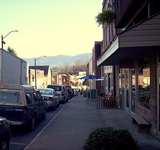
Whitesburg is a home rule-class city in and the county seat of Letcher County, Kentucky, United States. The population was 2,139 at the 2010 census and an estimated 1,875 in 2018. It was named for John D. White, a state politician.

<span class="mw-page-title-main">Mount Sterling, Kentucky</span> City in Kentucky, United States

Mount Sterling, often written as Mt. Sterling, is a home rule-class city in Montgomery County, Kentucky, United States. The population was 7,558 as of the 2020 census, up from 6,895 in 2010. It is the county seat of Montgomery County and the principal city of the Mount Sterling micropolitan area.

<span class="mw-page-title-main">Pound, Virginia</span> Town in Virginia, United States

Pound is a town in Wise County, Virginia, United States. The population was recorded as 1,037 in the 2010 United States Census.

<span class="mw-page-title-main">Cumberland River</span> River in Kentucky and Tennessee, United States

The Cumberland River is a major waterway of the Southern United States. The 688-mile-long (1,107 km) river drains almost 18,000 square miles (47,000 km2) of southern Kentucky and north-central Tennessee. The river flows generally west from a source in the Appalachian Mountains to its confluence with the Ohio River near Paducah, Kentucky, and the mouth of the Tennessee River. Major tributaries include the Obey, Caney Fork, Stones, and Red Rivers.

<span class="mw-page-title-main">Cumberland Mountains</span> Mountain range in the southeastern United States

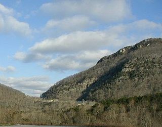
The Cumberland Mountains are a mountain range in the southeastern section of the Appalachian Mountains. They are located in western Virginia, southwestern West Virginia, the eastern edges of Kentucky, and eastern middle Tennessee, including the Crab Orchard Mountains. Their highest peak, with an elevation of 4,223 feet (1,287 m) above mean sea level, is High Knob, which is located near Norton, Virginia.

<span class="mw-page-title-main">U.S. Route 119</span> Highway in the United States

U.S. Route 119 (US 119) is a spur of US 19. It is a north–south route that was an original United States highway of 1926. It is Corridor G of the Appalachian Development Highway System (ADHS) east of US 23 and KY 80 in Kentucky to Interstate 64 at Charleston, West Virginia.

<span class="mw-page-title-main">Wilderness Road</span> Historic highway in Kentucky

The Wilderness Road was one of two principal routes used by colonial and early national era settlers to reach Kentucky from the East. Although this road goes through the Cumberland Gap into southern Kentucky and northern Tennessee, the other is sometimes called the "Cumberland Road" because it started in Fort Cumberland in Maryland. Despite Kentucky Senator Henry Clay's advocacy of this route, early in the 19th century, the northern route was selected for the National Road, connecting near Washington, Pennsylvania into the Ohio Valley of northern Kentucky and Ohio.

<span class="mw-page-title-main">Cumberland Gap</span> Narrow pass through the Cumberland Mountains

The Cumberland Gap is a pass in the eastern United States through the long ridge of the Cumberland Mountains, within the Appalachian Mountains and near the tripoint of Kentucky, Virginia, and Tennessee. At an elevation of 1,631 feet (497 m) above sea level, it is famous in American colonial history for its role as a key passageway through the lower central Appalachians.

<span class="mw-page-title-main">Big Sandy Expedition</span> 1861 campaign in the American Civil War

The Big Sandy Expedition was an early campaign of the American Civil War in Kentucky that began in mid-September 1861 when Union Brig. Gen. William "Bull" Nelson received orders to organize a new brigade at Maysville, Kentucky and conduct an expedition into the Big Sandy Valley region of Eastern Kentucky and stop the build-up of Confederate forces under Col. John S. Williams. This was done in three phases. From September 21 to October 20, 1861, Nelson assembled a brigade of 5,500 Union volunteers from Ohio and Kentucky. On October 23, the southern prong secured Hazel Green and the northern prong West Liberty. The two prongs were consolidated at Salyersville and they began the final phase on October 31. This led to the Battle of Ivy Mountain on November 8 and the withdrawal of Confederate forces from Pikeville (Piketon) on November 9, 1861.

<span class="mw-page-title-main">Angeles Forest Highway</span> Highway in California

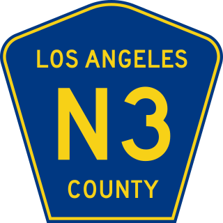
The Angeles Forest Highway is a 25-mile (40 km) road over the San Gabriel Mountains in Los Angeles County, California. It connects the Los Angeles Basin with the Antelope Valley and western Mojave Desert. Maintained by the Los Angeles County Department of Public Works, the highway is designated as County Route N-3 (CR N-3) or Forest Highway 59 (FH 59); the route numbers are unsigned, but noted on many maps.

<span class="mw-page-title-main">Kentucky Route 11</span> Highway in Kentucky

Kentucky Route 11 (KY 11) is an American highway maintained by the Kentucky Transportation Cabinet that runs from Maysville to Barbourville. The route from Maysville to Mount Sterling is being upgraded on a new alignment as part of a "macro-corridor" within the state of Kentucky.

<span class="mw-page-title-main">Bad Branch Falls State Nature Preserve</span>

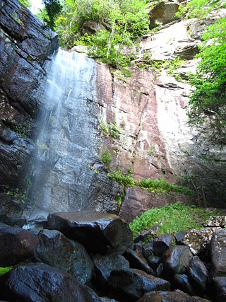
Bad Branch Falls State Nature Preserve is a forested gorge covering 2,639 acres near Whitesburg, KY in Letcher County, Kentucky. The deep and narrow gorge, adjacent to the Jefferson National Forest is carved into the face of Pine Mountain. Sandstone boulders and cliffs along with riglines and knobs provide views into the Appalachia area. The terrain is landscaped with streams, rivers, and a 60-foot waterfall. With a variety of habitat types, this nature preserve is home to many unique and unknown species of flora and fauna.

<span class="mw-page-title-main">Kentucky Route 160</span>

Kentucky Route 160, also known as KY 160, is a state highway in the U.S. state of Kentucky. It runs from the Virginia state line, where the roadway continues east to Appalachia, Virginia as State Route 160, north via Lynch, Benham, Clutts, Cumberland, Sand Hill, Gordon, Linefork, Kings Creek, Premium, and Hot Spot to Kentucky Route 15 at Van. KY 160 overlaps KY 15 through Isom to Cody, where it splits to run via Carr Creek, Brinkley, and Hindman, ending at Kentucky Route 1087 at Vest. Due to the mountainous terrain and numerous tight bends. KY 160 is signposted closed to tractor-trailers from Lynch to the Virginia state line.

<span class="mw-page-title-main">Kentucky Route 15</span> Highway in Kentucky

Kentucky Route 15 begins at a junction of US 119/Corridor F & Business KY 15 in Whitesburg, and terminates in Winchester at US 60. It is a major route, connecting the coalfields of the Cumberland Plateau with Lexington and other cities in the Bluegrass region. The segment from Whitesburg to KY 15 at Campton, which in turn connects to the Bert T. Combs Mountain Parkway near the town, is also the primary part of Corridor I of the Appalachian Development Highway System.

<span class="mw-page-title-main">Index of Kentucky-related articles</span>

The following is an alphabetical list of articles related to the United States Commonwealth of Kentucky.

The 45th Kentucky Mounted Infantry Regiment was a mounted infantry regiment that served in the Union Army during the American Civil War.

Oven Fork is an unincorporated community in Letcher County, Kentucky. Oven Fork is located on U.S. Route 119 and the Cumberland River 4.2 miles (6.8 km) south of Whitesburg. Oven Fork had a post office from 1948 to 1993.

Leonard Woods was an African-American man who was lynched by a mob in Pound Gap, on the border between Kentucky and Virginia, after they broke him out of jail in Whitesburg, Kentucky, on November 30, 1927. Woods was alleged to have killed the foreman of a mine, Herschel Deaton. A mob of people from Kentucky and Virginia took him from the jail and away from town and hanged him, and riddled his body with shots. The killing, which became widely publicized, was the last in a long line of extrajudicial murders in the area, and, prompted by the activism of Louis Isaac Jaffe and others, resulted in the adoption of strong anti-lynching legislation in Virginia.

References

  1. Pound Gap Kentucky Atlas and Gazetteer. Retrieved on 2010-06-20
  2. 1 2 3 Pound Gap overview Archived 2010-09-05 at the Wayback Machine Pound Gap High School. Retrieved on 2010-06-20
  3. 1 2 Historical Sketches of Southwest Virginia - Online edition Retrieved on 2010-06-20
  4. Oldest House in the Valley - Chapter One - Online edition Retrieved on 2010-06-20
  5. "RootsWeb: WEBB-L [WEBB] Early Families of Letcher County, KY (WEBB)". archiver.rootsweb.ancestry.com. Archived from the original on 2015-11-17.
  6. The Oldest House in the Valley - Chapter 6 - Online edition Retrieved on 2010-06-20
  7. Overview of Mount Sterling, Kentucky Kentucky Atlas and Gazetteer. Retrieved on 2010-06-20
  8. Brothers Once More War Monument Retrieved on 2010-06-20
  9. Leidholdt, Alexander (2011). ""never Thot This Could Happen in the South!" the". Appalachian Journal. 38 (2/3): 198–232. JSTOR   41320297.
  10. "NEGRO IS LYNCHED AS KENTUCKY KILLER; Alleged Slayer Is Taken From Jail Into Virginia and There Shot, Then Burned. VIRGINIANS ARE BLAMED Stand From Which New Interstate Highway Was Dedicated Is Used for Funeral Pyre". The New York Times. 1927-12-01. ISSN   0362-4331 . Retrieved 2020-04-04.
  11. Federal Writers' Project (1996). The WPA Guide to Kentucky. University Press of Kentucky. p. 242. ISBN   0813108659 . Retrieved 24 November 2013.
  12. Environmental Achievements: Pound Gap Thrust Fault Kentucky Transportation Cabinet. Retrieved on 2010-06-22
  13. Kuehn, Ken (August 17, 1999). "Pound Gap Roadcut: Kentucky's First "Distinguished Geologic Site"". Geogram . Archived from the original on April 23, 2002. Retrieved 2010-06-22.{{cite news}}: CS1 maint: bot: original URL status unknown (link)
  14. KSPG Awards Retrieved on 2010-06-22