Waynesboro is an independent city in the Commonwealth of Virginia. As of the 2020 census, the population was 22,196.

The Great Appalachian Valley, also called The Great Valley or Great Valley Region, is one of the major landform features of eastern North America. It is a gigantic trough—a chain of valley lowlands—and the central feature of the Appalachian Mountain system. The trough stretches about 1,200 miles (1,900 km) from Quebec to Alabama and has been an important north–south route of travel since prehistoric times.

The Ridge-and-Valley Appalachians, also called the Ridge and Valley Province or the Valley and Ridge Appalachians, are a physiographic province of the larger Appalachian division and are also a belt within the Appalachian Mountains extending from southeastern New York through northwestern New Jersey, westward into Pennsylvania and southward into Maryland, West Virginia, Virginia, Kentucky, Tennessee, Georgia and Alabama. They form a broad arc between the Blue Ridge Mountains and the Appalachian Plateau physiographic province. They are characterized by long, even ridges, with long, continuous valleys in between.

The Emory River is a river draining a portion of Tennessee's Cumberland Plateau. It flows for just over 46 miles (74 km) from its source near Frozen Head State Park to its mouth along the Clinch River at Kingston, Tennessee.

Skyline Drive is a 105-mile (169 km) National Parkway that runs the entire length of the National Park Service's Shenandoah National Park in the Blue Ridge Mountains of Virginia, generally along the ridge of the mountains. The drive's northern terminus is at an intersection with U.S. Route 340 (US 340) near Front Royal, and the southern terminus is at an interchange with US 250 near Interstate 64 (I-64) in Rockfish Gap, where the road continues south as the Blue Ridge Parkway. The road has intermediate interchanges with US 211 in Thornton Gap and US 33 in Swift Run Gap. Skyline Drive is part of Virginia State Route 48, which also includes the Virginia portion of the Blue Ridge Parkway, but this designation is not signed.

The Virginia Central Railroad was an early railroad in the U.S. state of Virginia that operated between 1850 and 1868 from Richmond westward for 206 miles (332 km) to Covington. Chartered in 1836 as the Louisa Railroad by the Virginia General Assembly, the railroad began near the Richmond, Fredericksburg and Potomac Railroad's line and expanded westward to Orange County, reaching Gordonsville by 1840. In 1849, the Blue Ridge Railroad was chartered to construct a line over the Blue Ridge Mountains for the Louisa Railroad which reached the base of the Blue Ridge in 1852. After a decision from the U.S. Supreme Court, the Louisa Railroad was allowed to expand eastward from a point near Doswell to Richmond.

The Blue Ridge Railroad was incorporated by the Commonwealth of Virginia in March 1849 to provide a state-financed crossing of the Blue Ridge Mountains for the Virginia Central Railroad, which it became a part of after completion.
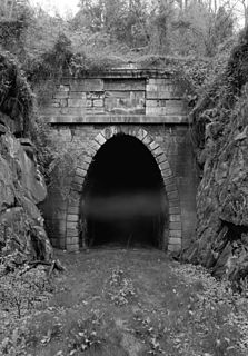
The Blue Ridge Tunnel is a historic railroad tunnel built during the construction of the Blue Ridge Railroad in the 1850s. The tunnel was the westernmost and longest of four tunnels engineered by Claudius Crozet to cross the Blue Ridge Mountains at Rockfish Gap in central Virginia.
The Virginia and Tennessee Railroad was an historic 5 ft gauge railroad in the Southern United States, much of which is incorporated into the modern Norfolk Southern Railway. It played a strategic role in supplying the Confederacy during the American Civil War.

Rockfish Gap is a wind gap located in the Blue Ridge Mountains between Charlottesville and Waynesboro, Virginia, United States, through Afton Mountain, which is frequently used to refer to the gap.
Swift Run Gap is a wind gap in the Blue Ridge Mountains located in the U.S. state of Virginia.

Covington and Ohio Railroad was part of a planned railroad link between Eastern Virginia and the Ohio River in the 1850s. The mountainous region of the Allegheny Front of the Appalachian Plateau between an existing canal, railroads and navigable rivers represented a formidable obstacle.
Buford's Gap is a wind gap in the Blue Ridge Mountains in Bedford County, Virginia. Buford's Gap was the original crossing of the Blue Ridge Mountains for the Virginia and Tennessee Railroad, later the Norfolk and Western Railway, a precursor of today's Norfolk Southern Railway system. It was the site of a battle in 1864 during the American Civil War. U.S. Route 460 also passes through the gap.
Clinch Mountain is a mountain ridge in the U.S. states of Tennessee and Virginia, lying in the ridge-and-valley section of the Appalachian Mountains. From its southern terminus at Kitts Point, which lies at the intersection of Knox, Union and Grainger counties near Blaine, Tennessee, it runs in a generally east-northeasterly direction to Garden Mountain near Burke's Garden, Virginia. It separates the Clinch River basin, to the north, and the Holston River basin, to the south.
Powell Mountain is a mountain ridge of the Ridge-and-valley Appalachians of the Appalachian Mountains. It is a long and narrow ridge, running northeast to southwest, from about Norton, Virginia to near Tazewell, Tennessee. It separates the Clinch River basin and the Powell River basin of Powell Valley. It was named for an 18th-century explorer.
U.S. Route 60 (US 60) in the Commonwealth of Virginia runs 303 miles (488 km) west to east through the central part of the state, generally close to and paralleling the Interstate 64 corridor, except for the crossing of the Blue Ridge Mountains, and in the South Hampton Roads area.
The Tennessee Valley Divide is the boundary of the drainage basin of the Tennessee River and its tributaries.
The Greenwood Tunnel is a historic railroad tunnel constructed in 1853 by Claudius Crozet during the construction of the Blue Ridge Railroad. The tunnel was the easternmost tunnel in a series of four tunnels used to cross the Blue Ridge Mountains of Virginia. Located near Greenwood in Albemarle County, Virginia, the tunnel was used by the Chesapeake and Ohio Railway (C&O) until its abandonment in 1944. The tunnel still exists, though sealed, next to the old C&O line, now owned by CSX Transportation and leased to the Buckingham Branch Railroad, which runs through a cut bypassing the old tunnel.

Pisgah Mountain or Pisgah Ridge is a ridgeline running 12.5 miles (20.1 km) from Tamaqua to Jim Thorpe, Pennsylvania. It is oriented north-northeast to south-southwest, and its north-side valley is followed by U.S. Route 209 from river gap to river gap. The ridge is a succession of peaks exceeding 1,440 feet (438.9 m) rising 300 to 540 feet above the boroughs of Lansford, Coaldale, and Tamaqua in the Panther Creek valley. The highest point on Pisgah Mountain is at 1,611 feet (491 m) in the borough of Summit Hill, which sits atop the ridge. Near Summit Hill was the "Sharpe Mountain" (peak) where in 1791 Phillip Ginter is documented as having discovered anthracite, leading to the formation of the Lehigh Coal Mine Company. In 1818 the Lehigh Coal Company took over the mines, and the mining camp gradually became a settlement and grew into Summit Hill.
The gaps of the Allegheny, meaning gaps in the Allegheny Ridge in west-central Pennsylvania, is a series of escarpment eroding water gaps along the saddle between two higher barrier ridge-lines in the eastern face atop the Allegheny Ridge or Allegheny Front escarpment. The front extends south through Western Maryland and forms much of the border between Virginia and West Virginia, in part explaining the difference in cultures between those two post-Civil War states. While not totally impenetrable to daring and energetic travelers on foot, passing the front outside of the water gaps with even sure footed mules was nearly impossible without navigating terrain where climbing was necessary on slopes even burros would find extremely difficult.