Wise County, Virginia

Last updated

Wise County
Wise County Courthouse - Front View.JPG
Wise County Seal.jpg
Map of Virginia highlighting Wise County.svg
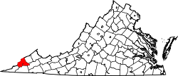
Location within the U.S. state of Virginia
Virginia in United States.svg
Virginia's location within the U.S.
Coordinates: 36°58′N82°37′W / 36.97°N 82.62°W / 36.97; -82.62
CountryFlag of the United States.svg United States
StateFlag of Virginia.svg  Virginia
Founded1856
Named for Henry A. Wise
Seat Wise
Largest town Big Stone Gap
Area
  Total405 sq mi (1,050 km2)
  Land403 sq mi (1,040 km2)
  Water2 sq mi (5 km2)  0.5%
Population
 (2020)
  Total36,130 Decrease2.svg
Time zone UTC−5 (Eastern)
  Summer (DST) UTC−4 (EDT)
Congressional district 9th
Website www.wisecounty.org

Wise County is a county located in the U.S. state of Virginia. The county was formed in 1856 from Lee, Scott, and Russell Counties and named for Henry A. Wise, who was the Governor of Virginia at the time.

Contents

History

The Cherokee colonized the area including Wise from the Xualae between 1671 and 1685. It was later contested by the Six Nations and the Shawnee. Cherokee and Shawnee hunting parties fought a protracted battle at the headwaters of the Clinch River for two days in the summer of 1786, a victory for the Cherokee although losses were heavy on both sides.

The first white explorers to reach present-day Wise county are said to have been Thomas Walker and Christopher Gist, both in 1750. Several forts were built all along the Clinch from 1774 onward, but only after Chickamauga Cherokee leader Bob Benge was slain in 1794 was present-day Wise considered safe for white settlers even to hunt in. One of the earliest settlers within the county was William Wells around 1792. [1]

In the 1880s, coal deposits became the dominant resource utilized in the area. The Stonega Coke and Coal Company (SC&C) was formed in the town of Appalachia, Virginia. [2] Immigration trends and economic conditions across the country attracted many people to the area for work, including African Americans and Irish, Polish, Italian, and Hungarian immigrants.

Virginia's two highest security state prisons are located in Wise County: Red Onion State Prison, opened in 1998, and Wallens Ridge State Prison, opened in 1999. [3]

In July 2012 Dominion Energy built Virginia City Hybrid Energy Center in Wise County, a hybrid power plant that burns 80% coal and up to 20% biomass. In 2014, the plant was fined $47,651 by the Virginia Department of Environmental Quality for emitting carbon monoxide and other gases at levels exceeding state regulations. [4]

Geography

Powell Valley, as viewed from Benge's Gap Benges Gap.jpg
Powell Valley, as viewed from Benge's Gap

According to the U.S. Census Bureau, the county has a total area of 405 square miles (1,050 km2), of which 403 square miles (1,040 km2) is land and 2 square miles (5.2 km2) (0.5%) is water. [5] The county is part of the Appalachians and has many mountainous features, including the peak of High Knob and Powell Valley.

Adjacent counties and cities

Major highways

National protected area

Demographics

Historical population
CensusPop.Note
1860 4,508
1870 4,7856.1%
1880 7,77262.4%
1890 9,34520.2%
1900 19,653110.3%
1910 34,16273.8%
1920 46,50036.1%
1930 51,16710.0%
1940 52,4582.5%
1950 56,3367.4%
1960 43,579−22.6%
1970 35,947−17.5%
1980 43,86322.0%
1990 39,573−9.8%
2000 40,1231.4%
2010 41,4523.3%
2020 36,130−12.8%
U.S. Decennial Census [6]
1790-1960 [7] 1900–1990 [8]
1990-2000 [9] 2010 [10] 2020 [11]

2020 census

Wise County, Virginia - Demographic Profile
(NH = Non-Hispanic)
Race / EthnicityPop 2010 [10] Pop 2020 [11] % 2010% 2020
White alone (NH)38,30132,58692.40%90.19%
Black or African American alone (NH)2,1181,7715.11%4.90%
Native American or Alaska Native alone (NH)51480.12%0.13%
Asian alone (NH)1411500.34%0.42%
Pacific Islander alone (NH)2110.00%0.03%
Some Other Race alone (NH)20860.05%0.24%
Mixed Race/Multi-Racial (NH)3481,0260.84%2.84%
Hispanic or Latino (any race)4714521.14%1.25%
Total41,45236,130100.00%100.00%

Note: the US Census treats Hispanic/Latino as an ethnic category. This table excludes Latinos from the racial categories and assigns them to a separate category. Hispanics/Latinos can be of any race.

2000 Census

As of the census [12] of 2010, there were 41,452 people, 15,968 households, and 10,892 families residing in the county. The population density was 102.8 people per square mile (39.7 people/km2). There were 17,940 housing units at an average density of 44 units per square mile (17 units/km2). The racial makeup of the county was 93% White, 5.2% Black or African American, 0.10% Native American, 0.30% Asian, 0.01% Pacific Islander, and 0.90% from two or more races. 1.10% of the population were Hispanic or Latino of any race.

There were 15,968 households, out of which 31.80% had children under the age of 18 living with them, 50,30% were married couples living together, 12.60% had a female householder with no husband present, and 31.80% were non-families. 27.40% of all households were made up of individuals, and 11.40% had someone living alone who was 65 years of age or older. The average household size was 2.40 and the average family size was 2.90.

In the county, the population was spread out, with 20.80% under the age of 18 and 14.10% who were 65 years of age or older. The median age was 39 years. For every 100 females there were 107 males. For every 100 females age 18 and over, there were 107.08 males.

The median income for a household in the county was $35,053. The per capita income for the county was $17,512. About 19.30% of the population were below the poverty line. The homeownership rate for the county is 70.00%

Education

Public schools

Wise County Public Schools operates thirteen school facilities in the county for its students. [13] For several years the Wise County School Board has considered consolidating high schools, and in 2011 it consolidated six high schools into three; Union High which serves the western part of the county, Central High which serves the central and northern parts of the county, and Eastside High which serves the eastern part of the county.

Private schools

Wise County Christian School operates as a private school in the county.

Colleges and universities

Media

Newspapers

Radio stations

Tourist attractions

Natural and outdoor recreation

High Knob Observation Tower Cnv0147.jpg
High Knob Observation Tower

A large portion of the Jefferson National Forest is contained within Wise County, and the Clinch River winds through the county. These two factors, combined with Wise County's location in the Appalachian Mountains, mean that Wise County offers many opportunities for outdoor recreation.

In addition to many trails connecting to and surrounding the Appalachian Trail system, Wise county is home to many parks, including Miners' Park in Big Stone Gap and the Louis E. Henegar Miners' Memorial Park in Appalachia.

Among the unique features of Wise County are High Knob, a mountain which featured one of the last remaining Appalachian Fire Towers until its destruction by arson on October 31, 2007, [15] and Wetlands Estonoa, an Appalachian Wetland and part of the Clinch River Watershed.

Theater and the arts

Festivals and fairs

Historical

Sports

UVa-Wise hosts NCAA Division II Baseball, Basketball, Football, Lacrosse, Softball, and other inter-collegiate games on the campus of UVa-Wise.

Communities

Towns

Census-designated places

Notable people

Politics

United States presidential election results for Wise County, Virginia [19]
Year Republican Democratic Third party
No.%No.%No.%
2020 13,36680.45%3,11018.72%1390.84%
2016 12,08679.71%2,70117.81%3762.48%
2012 11,07673.75%3,76025.04%1821.21%
2008 8,91463.05%4,99535.33%2291.62%
2004 8,33058.20%5,80240.54%1801.26%
2000 6,50448.87%6,41248.17%3942.96%
1996 4,66035.59%6,71251.27%1,72013.14%
1992 5,14434.62%7,68151.70%2,03213.68%
1988 6,18946.23%7,01752.42%1801.34%
1984 7,90951.36%7,30347.43%1871.21%
1980 5,76743.89%6,77951.59%5954.53%
1976 5,69142.63%7,13453.43%5263.94%
1972 6,73959.94%4,40239.16%1010.90%
1968 5,00439.70%5,94247.14%1,66013.17%
1964 3,30931.40%7,22068.51%100.09%
1960 3,87639.89%5,82259.92%180.19%
1956 4,87146.41%5,56753.04%570.54%
1952 3,91145.16%4,72954.61%200.23%
1948 2,83636.15%4,86261.98%1471.87%
1944 1,81728.30%4,58871.46%150.23%
1940 1,44824.14%4,53875.66%120.20%
1936 2,05727.54%5,39972.28%140.19%
1932 2,40531.06%5,27668.13%630.81%
1928 4,50449.70%4,55950.30%00.00%
1924 3,32240.39%4,15750.55%7459.06%
1920 3,23655.29%2,58744.20%300.51%
1916 1,86255.33%1,46843.63%351.04%
1912 85131.08%1,27946.71%60822.21%

Related Research Articles

<span class="mw-page-title-main">Colbert County, Alabama</span> County in Alabama, United States

Colbert County is a county located in the northwestern part of the U.S. state of Alabama. As of the 2020 census the county's population was 57,227. The county seat is Tuscumbia. The largest city is Muscle Shoals.

<span class="mw-page-title-main">Scott County, Virginia</span> County in Virginia, United States

Scott County is a county located in the southwestern part of the U.S. state of Virginia. As of the 2020 census, the population was 21,576. Its county seat is Gate City. Scott County was formed by an act of the General Assembly on November 24, 1814, from parts of Washington, Lee, and Russell Counties and was named for Virginia born General Winfield Scott. Scott County is part of the Kingsport–Bristol–Bristol, TN-VA Metropolitan Statistical Area, which is a component of the Johnson City–Kingsport–Bristol, TN-VA Combined Statistical Area, commonly known as the "Tri-Cities" region. The County Administrator is Freda Russell Starnes.

<span class="mw-page-title-main">Lee County, Virginia</span> County in Virginia, United States

Lee County is the westernmost county in the U.S. Commonwealth of Virginia. As of the 2020 census, the population was 22,173. Its county seat is Jonesville.

<span class="mw-page-title-main">Buchanan County, Virginia</span> County in Virginia, United States

Buchanan County is a United States county in far western Virginia, the only county in the state to border both West Virginia and Kentucky. The county is part of the Southwest Virginia region and lies in the rugged Appalachian Plateau portion of the Appalachian Mountains. Its county seat is Grundy.

<span class="mw-page-title-main">Union County, Tennessee</span> County in Tennessee, United States

Union County is a county located in the U.S. state of Tennessee. As of the 2020 census, its population was 19,802. Its county seat is Maynardville. Union County is included in the Knoxville metropolitan statistical area.

<span class="mw-page-title-main">Monroe County, Tennessee</span> County in Tennessee, United States

Monroe County is a county located on the eastern border of the U.S. state of Tennessee. As of the 2020 census, the population was 46,250. Its county seat is Madisonville, and its largest city is Sweetwater.

<span class="mw-page-title-main">Rabun County, Georgia</span> County in Georgia, United States

Rabun County is the north-easternmost county in the U.S. state of Georgia. As of the 2020 census, the population was 16,883, up from 16,276 in 2010. The county seat is Clayton. With an average annual rainfall of over 70 inches (1,800 mm), Rabun County has the title of the rainiest county in Georgia and is one of the rainiest counties east of the Cascades. The year 2018 was the wettest on record in the county's history. The National Weather Service cooperative observation station in northwest Rabun's Germany Valley measured 116.48 inches of rain during the year. During 2020, the Germany Valley NWS station reported a yearly precipitation total of 100.19 inches.

<span class="mw-page-title-main">Tazewell, Tennessee</span> Town in Tennessee, United States

Tazewell is a town in and the county seat of Claiborne County, Tennessee, United States. The population was 2,165 at the 2000 census, 2,218 at the 2010 census, and 2,348 at the 2020 census. The town is named for Tazewell, Virginia, which itself was named for Henry Tazewell (1753–1799), a U.S. senator from Virginia.

<span class="mw-page-title-main">Appalachia, Virginia</span> Town in Virginia, United States

Appalachia is a town in Wise County, Virginia, United States. The population was 1,754 at the 2010 census.

<span class="mw-page-title-main">Big Stone Gap, Virginia</span> Town in Virginia, United States

Big Stone Gap is a town in Wise County, Virginia, United States. The town was economically centered around the coal industry for much of its early development. The population was 5,254 at the 2020 census.

<span class="mw-page-title-main">Coeburn, Virginia</span> Town in Virginia, United States

Coeburn is a town in Wise County, Virginia, United States, along the Guest River. The population was 2,139 at the 2010 census.

<span class="mw-page-title-main">Tazewell County, Virginia</span> County in Virginia, United States

Tazewell County is a county located in the southwestern portion of the U.S. state of Virginia. As of the 2020 census, the population was 40,429. Its county seat is Tazewell.

<span class="mw-page-title-main">Powell Valley</span> Valley in Virginia, US

Powell Valley in southwest Virginia, in the United States, is located near the city of Norton and the town of Big Stone Gap in Wise County, Virginia.

<span class="mw-page-title-main">U.S. Route 23 in Virginia</span>

U.S. Route 23 (US 23) is a part of the United States Numbered Highway System that runs from Jacksonville, Florida, to Mackinaw City, Michigan. In Virginia, the U.S. Highway runs 60.80 miles (97.85 km) from the Tennessee state line near Weber City north to the Kentucky state line near Pound. US 23, which is known as Orby Cantrell Highway for most of its course, is a four-lane divided highway that follows Corridor B of the Appalachian Development Highway System through Southwest Virginia. The U.S. Highway serves as the main east–west highway of Scott County and the primary north–south highway of Wise County. US 23 runs concurrently with US 58 from Weber City to Duffield and with US 58 Alternate between Big Stone Gap and the independent city of Norton.

<span class="mw-page-title-main">Clinch Mountain</span> Mountain ridge in Tennessee and Virginia, United States

Clinch Mountain is a mountain ridge in the U.S. states of Tennessee and Virginia, lying in the ridge-and-valley section of the Appalachian Mountains. From its southern terminus at Kitts Point, which lies at the intersection of Knox, Union and Grainger counties near Blaine, Tennessee, it runs in a generally east-northeasterly direction to Garden Mountain near Burke's Garden, Virginia. It separates the Clinch River basin to the north and the Holston River basin to the south.

Powell Mountain is a mountain ridge of the Ridge-and-valley Appalachians of the Appalachian Mountains. It is a long and narrow ridge, running northeast to southwest, from about Norton, Virginia, to near Tazewell, Tennessee. It separates the Clinch River basin and the Powell River basin of Powell Valley. It was named for an 18th-century explorer.

<span class="mw-page-title-main">U.S. Route 58 Alternate</span>

U.S. Route 58 Alternate is a 87.40-mile-long (140.66 km) alternate route to US 58 in western Virginia. The route is a northern bypass to US 58 which stays closer to the Tennessee border and serves Gate City and Bristol.

<span class="mw-page-title-main">Del Rio, Tennessee</span> Unincorporated community in Tennessee, United States

Del Rio is an unincorporated community in Cocke County, Tennessee, United States. Although it is not a census-designated place, the ZIP Code Tabulation Area for the ZIP Code (37727) that serves Del Rio had a population of 2,138, according to the 2000 census.

<span class="mw-page-title-main">Linville, North Carolina</span> Census-designated place in North Carolina, United States

Linville is an unincorporated community and census-designated place (CDP) in Avery County, North Carolina, United States. It was first listed as a CDP in the 2020 census with a population of 283. Centered just south of US 221 and NC 105, the community is known as a summer mountain resort and host of the Grandfather Mountain Highland Games, the largest modern Highland games events in North Carolina.

<span class="mw-page-title-main">Moccasin Gap</span>

Moccasin Gap, also known as Big Moccasin Gap, is a pass in Clinch Mountain, a long ridge within the Appalachian Mountains, at Gate City, Virginia. This gap has a long history as a passageway through the mountain. It was used by the Cherokee and Shawnee, and was the first gap through which the Daniel Boone Wilderness Road passed on its way to the better-known Cumberland Gap and Kentucky. Today it serves as a primary commercial route for industry, retail, and tourism businesses.

References

  1. Luther Foster Addison, 1988, The Story of Wise County pp. 1–26
  2. "Southwest Virginia Museum Historical State Park". www.swvamuseum.org. Archived from the original on June 20, 2019. Retrieved June 22, 2019.
  3. VA Continues Program Recognized for Transforming Highest-Security Prisons
  4. "State Air Pollution Control Board Enforcement Action- Order By Consent Issued To Virginia Electric Power Company, D/B/A Dominion Virginia Power For The Virginia City Hybrid Energy Center" (PDF). Virginia Department of Environmental Quality. Archived (PDF) from the original on January 26, 2017. Retrieved May 14, 2018.
  5. "US Gazetteer files: 2010, 2000, and 1990". United States Census Bureau. February 12, 2011. Archived from the original on August 24, 2019. Retrieved April 23, 2011.
  6. "Census of Population and Housing from 1790-2000". US Census Bureau . Retrieved January 24, 2022.
  7. "Historical Census Browser". University of Virginia Library. Archived from the original on August 11, 2012. Retrieved January 5, 2014.
  8. "Population of Counties by Decennial Census: 1900 to 1990". United States Census Bureau. Archived from the original on December 15, 2013. Retrieved January 5, 2014.
  9. "Census 2000 PHC-T-4. Ranking Tables for Counties: 1990 and 2000" (PDF). United States Census Bureau. Archived (PDF) from the original on December 18, 2014. Retrieved January 5, 2014.
  10. 1 2 "P2 HISPANIC OR LATINO, AND NOT HISPANIC OR LATINO BY RACE - 2010: DEC Redistricting Data (PL 94-171) - Wise County, Virginia". United States Census Bureau .
  11. 1 2 "P2 HISPANIC OR LATINO, AND NOT HISPANIC OR LATINO BY RACE - 2020: DEC Redistricting Data (PL 94-171) - Wise County, Virginia". United States Census Bureau .
  12. "U.S. Census website". United States Census Bureau. Archived from the original on December 27, 1996. Retrieved May 14, 2011.
  13. "Wise County Public Schools > Home". Archived from the original on May 18, 2013. Retrieved July 26, 2016.
  14. 1 2 "Coalfield Progress Online" . Retrieved October 5, 2023.
  15. "Spark It Up!!!: High Knob Tower Burns". Archived from the original on October 13, 2016. Retrieved July 26, 2016.
  16. "Applachian Children's Theatre Introduction". Archived from the original on April 15, 2009. Retrieved October 5, 2023.
  17. "WELCOME TO CLINCH RIVER DAYS!!!". Clinch River Days Festival. Archived from the original on March 7, 2018. Retrieved March 6, 2018.
  18. "Home | Wise County Famous Fall Fling" . Retrieved October 5, 2023.
  19. Leip, David. "Dave Leip's Atlas of U.S. Presidential Elections". uselectionatlas.org. Archived from the original on March 23, 2018. Retrieved December 9, 2020.