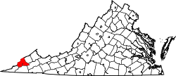
Big Stone Gap East, Virginia | |
---|---|
Coordinates: 36°52′56″N82°44′36″W / 36.88222°N 82.74333°W | |
Country | United States |
State | Virginia |
County | Wise |
Area | |
• Total | 0.48 sq mi (1.24 km2) |
• Land | 0.48 sq mi (1.24 km2) |
• Water | 0.0 sq mi (0.0 km2) |
Elevation | 1,540 ft (470 m) |
Population | 687 |
Time zone | UTC-5 (Eastern (EST)) |
• Summer (DST) | UTC-4 (EDT) |
ZIP Code | 24219 (Big Stone Gap) |
Area code | 276 |
FIPS code | 51-07484 |
GNIS feature ID | 2807471 [3] |
Big Stone Gap East is an unincorporated area and census-designated place (CDP) in Wise County, Virginia, United States. It was first listed as a CDP in the 2020 census with a population of 687. [4] [2]
The CDP is in the southwest part of the county, on the east edge of the town of Big Stone Gap, outside the town limits. U.S. Route 23 and 58 Alternate, a four-lane expressway, curves to the south and east of the community, separating it from East Stone Gap to the south. Norton is 8 miles (13 km) to the northeast.
Big Stone Gap East first appeared as a census designated place in the 2020 U.S. Census. [5]
Dryden is an unincorporated community and census-designated place (CDP) in Lee County, Virginia, United States. The population was 1,208 at the 2010 census.
Ewing is an unincorporated community and census-designated place (CDP) in Lee County, Virginia. The population was 439 at the 2010 U.S. Census. Ewing is one of the westernmost settlements in the Commonwealth of Virginia, before reaching the Cumberland Gap and the borders with Kentucky and Tennessee.
Keokee is an unincorporated community and census-designated place (CDP) in Lee County, Virginia, United States. The population was 416 at the 2010 census.
Big Stone Gap is a town in Wise County, Virginia, United States. The town was economically centered around the coal industry for much of its early development. The population was 5,254 at the 2020 census.
Bristol is the main settlement in the town of Bristol in Addison County, Vermont, United States, and a census-designated place (CDP). The population was 1,936 at the 2020 census, out of a total population of 3,782 in the town of Bristol.
Locust Mount is an unincorporated community and census-designated place (CDP) in Accomack County, Virginia, United States. It was first listed as a CDP in the 2020 census with a population of 52. The CDP is in southeastern Accomack County, on the north side of Virginia State Route 180, which leads east 1.1 kilometres (0.7 mi) to Wachapreague and west 3.5 miles (5.6 km) to U.S. Route 13 at Keller.
Bastian is an unincorporated community and census-designated place (CDP) in Bland County, Virginia, United States. Bastian is 4 miles (6 km) north-northwest of Bland. It was first listed as a CDP in the 2020 census with a population of 343. Bastian has a post office with ZIP code 24314.
Earling is an unincorporated community and census-designated place (CDP) in Logan County, West Virginia, United States. It was first listed as a CDP prior to the 2020 census. The Earling post office closed on July 1, 1989. The town now shares ZIP Code 25632 with Lyburn and Taplin.
Stonega is a Census-designated place and coal town located in Wise County, Virginia, United States. It is part of the Big Stone Gap, Virginia micropolitan area. The community was founded in 1895 to provide housing and coking facilities for the Virginia Coal and Iron Company before being leased to the Stonega Coke and Coal Company in 1902. The community was owned and operated as a company town until after World War II. Their post office closed in 2002.
Stickleyville is an unincorporated community and census-designated place (CDP) in Lee County, Virginia, United States. It has also been known as Stickleysville. The community was first listed as a CDP for the 2020 census.
East Stone Gap is an unincorporated community and census-designated place in Wise County, Virginia, United States. East Stone Gap is an eastern suburb of Big Stone Gap; U.S. Route 23 separates the two settlements. It was first listed as a CDP in the 2020 census with a population of 537. East Stone Gap has a post office with ZIP code 24246.
Kincora is a census-designated place in Loudoun County, Virginia, United States. The CDP was first drawn prior to the 2020 census.
Lincoln is the central settlement and a census-designated place (CDP) in the town of Lincoln, Addison County, Vermont, United States. It was first listed as a CDP prior to the 2020 census.
Hanksville is an unincorporated village and census-designated place (CDP) in the town of Huntington, Chittenden County, Vermont, United States. It was first listed as a CDP prior to the 2020 census.
Schooner Bay is a census-designated place (CDP) in Accomack County, Virginia, United States. It was first listed as a CDP in 2010. As of the 2020 census, it had a population of 97.
Hilltown is an unincorporated community and census-designated place (CDP) in Grayson and Carroll counties, Virginia, United States. As of the 2020 census, it had a population of 216.
Innovation is an unincorporated area and census-designated place (CDP) in Prince William County, Virginia, United States. As of the 2020 census, it had a population of 926.
Fairfield is an unincorporated community and census-designated place (CDP) in Rockbridge County, Virginia, United States. As of the 2020 census, it had a population of 257.
East View is an unincorporated community and census-designated place (CDP) in Harrison County, West Virginia, United States. As of the 2020 census, it had a population of 817.
West Dunbar is an unincorporated community and census-designated place (CDP) in Kanawha County, West Virginia, United States. As of the 2020 census, it had a population of 617.