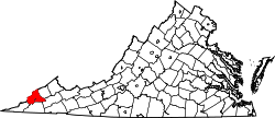
Osaka, Virginia

Last updated

Osaka, Virginia
USA Virginia location map.svg
Red pog.svg
Osaka, Virginia
Usa edcp location map.svg
Red pog.svg
Osaka, Virginia
Coordinates: 36°56′49″N82°48′39″W / 36.94694°N 82.81083°W / 36.94694; -82.81083 [1]
Country United States
State Virginia
County Wise
Area
  Total
0.431 sq mi (1.12 km2)
  Land0.431 sq mi (1.12 km2)
  Water0 sq mi (0 km2)
Elevation
1,801 ft (549 m)
Population
 (2020)
  Total
132
  Density306.3/sq mi (118.3/km2)
Time zone UTC-5 (Eastern (EST))
  Summer (DST) UTC-4 (EDT)
GNIS feature ID1493381 [1]

Osaka is a Census-designated place and coal town located in Wise County, Virginia, United States, served by a (now vanished) branch line of the Appalachia to Stonega railroad that ran along Mud Lick Creek to Roda, which was built in 1896 by Interstate Railroads. [2] [3]

Contents

Demographics

Osaka first appeared as a census designated place in the 2020 U.S. Census. [4]

Related Research Articles

<span class="mw-page-title-main">Jenkins, Kentucky</span> City in Kentucky, United States

Jenkins is a home rule-class city in Letcher County, Kentucky, United States. The population was 2,203 as of the 2010 census.

<span class="mw-page-title-main">Vaughn, Montana</span> CDP in Montana, United States

Vaughn is a census-designated place (CDP) in Cascade County, Montana, United States. The population was 737 at the 2020 census, compared to 658 at the 2010 census. It is part of the Great Falls, Montana Metropolitan Statistical Area. It is named for Montana pioneer Robert Vaughn, whose homestead on the Vaughn Ranch encompassed part of the town.

<span class="mw-page-title-main">Carbondale, Pennsylvania</span> City in Pennsylvania, United States

Carbondale is a city in Lackawanna County, Pennsylvania, United States. Carbondale is located approximately 15 miles due northeast of the city of Scranton in Northeastern Pennsylvania. The population was 8,828 at the 2020 census.

<span class="mw-page-title-main">Haysi, Virginia</span> Town in Virginia, United States

Haysi is a town in Dickenson County, Virginia, United States. The population was 498 at the 2010 census, up from 186 at the 2000 census, over which time period the town's area tripled.

<span class="mw-page-title-main">Appalachia, Virginia</span> Town in Virginia, United States

Appalachia is a town in Wise County, Virginia, United States. The population was 1,754 at the 2010 census.

<span class="mw-page-title-main">Imperial, Pennsylvania</span> Census-designated place in Pennsylvania, United States

Imperial is a census-designated place (CDP) in Allegheny County, Pennsylvania, United States and part of the Pittsburgh metropolitan area. The population was 2,722 at the 2020 census. The CDP is located in North Fayette and Findlay Townships, and geographically close to Pittsburgh International Airport.

<span class="mw-page-title-main">Midlothian, Virginia</span> Unincorporated community in Virginia, United States

Midlothian is an unincorporated area and census-designated place in Chesterfield County, Virginia, U.S. Settled as a coal town, Midlothian village experienced suburbanization effects and is now part of the western suburbs of Richmond, Virginia south of the James River in the Greater Richmond Region. Because of its unincorporated status, Midlothian has no formal government, and the name is used to represent the original small Village of Midlothian and a vast expanse of Chesterfield County in the northwest portion of Southside Richmond served by the Midlothian post office.

Page is a census-designated place (CDP) and coal town in Fayette County, West Virginia, United States. As of the 2010 census, its population was 224. It was named for William Nelson Page (1854-1932), a civil engineer and industrialist who lived in nearby Ansted, where he managed Gauley Mountain Coal Company and many iron, coal, and railroad enterprises.

Midlothian is an unincorporated community and census-designated place (CDP) in Allegany County, Maryland, United States; at one time it was called Midlothian Junction. As of the 2010 census it had a population of 320. Its ZIP code is 21543.

<span class="mw-page-title-main">Echo, Utah</span> CDP in Utah, United States

Echo is a census-designated place located in northwestern Summit County, Utah, United States. The population was 56 at the 2010 census.

<span class="mw-page-title-main">Cucumber, West Virginia</span> Census-designated place in West Virginia, United States

Cucumber is a census-designated place (CDP) in McDowell County, West Virginia, United States. Its population was 74 at the 2020 census. The community is centered on mining. Named either for nearby Cucumber Creek or for the cucumber trees in the area, it is the only community in the United States with this name. Its post office was still active as of October 2011.

Port Morris is a historic unincorporated community and census-designated place (CDP) in Roxbury Township, Morris County, New Jersey, United States. The community is in the hills of New Jersey's Skylands Region, on the shores of Lake Musconetcong.

<span class="mw-page-title-main">Tasley, Virginia</span> Census-designated place in Virginia, United States

Tasley is a census-designated place (CDP) in Accomack County, Virginia, United States. It was first listed as a CDP in 2010. Per the 2020 census, the population was 222.

Galloway is a census-designated place (CDP) and coal town in northwestern Barbour County, West Virginia, United States. It lies along West Virginia Route 76 northwest of the city of Philippi, the county seat of Barbour County. Its elevation is 1,073 feet (327 m). It has a post office with the ZIP code 26349. As of the 2010 census, its population is 143.

Crellin is an unincorporated community and census-designated place (CDP) in Garrett County, Maryland, United States, with a population of 264 as of the 2010 census.

The following is a brief history of the North American rail system, mainly through major changes to Class I railroads, the largest class by operating revenue.

<span class="mw-page-title-main">Helen, West Virginia</span> Census-designated place in West Virginia, United States

Helen is a census-designated place (CDP) in Raleigh County, West Virginia, United States. As of the 2010 census, its population was 219. West Virginia Route 16, Winding Gulf and railroad tracks run right through the community.

<span class="mw-page-title-main">Bastian, Virginia</span> Unincorporated community in Virginia, United States

Bastian is an unincorporated community and census-designated place (CDP) in Bland County, Virginia, United States. Bastian is 4 miles (6 km) north-northwest of Bland. It was first listed as a CDP in the 2020 census with a population of 343. Bastian has a post office with ZIP code 24314.

Wolf Summit is a census-designated place and coal town in Harrison County, West Virginia, United States. Its population was 272 as of the 2010 census.

Stonega is a Census-designated place and coal town located in Wise County, Virginia, United States. It is part of the Big Stone Gap, Virginia micropolitan area. The community was founded in 1895 to provide housing and coking facilities for the Virginia Coal and Iron Company before being leased to the Stonega Coke and Coal Company in 1902. The community was owned and operated as a company town until after World War II. Their post office closed in 2002.

References

  1. 1 2 GNIS.
  2. Prescott 1946, p. 112.
  3. Poor 1911, p. 464, INTERSTATE RR.
  4. "2020 Geography Changes". United States Census Bureau.

bibliography