Stonega, Virginia | |
|---|---|
 Stonega, Virginia  Stonega, Virginia | |
| Coordinates: 36°57′11″N82°47′29″W / 36.95306°N 82.79139°W | |
| Country | United States |
| State | Virginia |
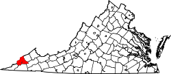
| County | Wise |
| Founded | July 15, 1895 |
| Area | |
• Total | 0.622 sq mi (1.61 km2) |
| • Land | 0.622 sq mi (1.61 km2) |
| • Water | 0 sq mi (0 km2) |
| Elevation | 1,818 ft (554 m) |
| Population (2020) | |
• Total | 93 |
| • Density | 149.5/sq mi (57.7/km2) |
| Time zone | UTC−5 (Eastern (EST)) |
| • Summer (DST) | UTC−4 (EDT) |
| ZIP codes | 24285 |
| GNIS feature ID | 1487603 [1] |
Stonega is a Census-designated place and coal town located in Wise County, Virginia, United States. [2] It is part of the Big Stone Gap, Virginia micropolitan area. The community was founded in 1895 to provide housing and coking facilities for the Virginia Coal and Iron Company before being leased to the Stonega Coke and Coal Company in 1902. [3] The community was owned and operated as a company town until after World War II. [4] Their post office closed in 2002. [5]