Louisa County | |
---|---|
![]() | |
![]() Location within the U.S. state of Virginia | |
![]() Virginia's location within the U.S. | |
Coordinates: 37°59′N77°58′W / 37.99°N 77.96°W | |
Country | ![]() |
State | ![]() |
Founded | 1742 |
Named for | Louise of Great Britain |
Seat | Louisa |
Largest town | Louisa |
Area | |
• Total | 511 sq mi (1,320 km2) |
• Land | 496 sq mi (1,280 km2) |
• Water | 15 sq mi (40 km2) 2.9% |
Population (2020) | |
• Total | 37,596 |
• Density | 74/sq mi (28/km2) |
Time zone | UTC−5 (Eastern) |
• Summer (DST) | UTC−4 (EDT) |
Congressional district | 5th |
Website | www |
Louisa County is a county located in the Commonwealth of Virginia. As of the 2020 census, the population was 37,596. [1] The county seat is Louisa. [2]
Prior to colonial settlement, the area comprising Louisa County was occupied by several indigenous peoples including the Tutelo, the Monacan, and the Manahoac peoples, who eventually fled to join the Cayuga Iroquois (Haudenosaunee) people in New York state under pressure from English settlers.
Louisa County was established in 1742 from Hanover County. The county is named for Princess Louise of Great Britain, youngest daughter of King George II, and wife of King Frederick V of Denmark. [3]
Patrick Henry lived for some time in Louisa County on Roundabout Creek in 1764. Henry was being mentored at that time by the Louisa County magnate Thomas Johnson the representative of Louisa County in the House of Burgesses. In 1765, Patrick Henry won his first election to represent Louisa County in the House of Burgesses. At the end of the eighteenth century and in the early nineteenth century, numerous free mixed-race families migrated together from here to Kentucky, where neighbors began to identify them as Melungeon. [ citation needed ]
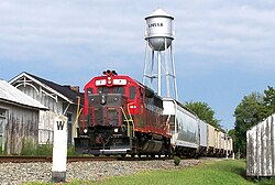
The Virginia Central Railroad was completed through Louisa County in 1838–1840. During the Civil War, it was an important supply line for the Confederate armies. As a result, several significant cavalry actions took place in the county, particularly one fought at Trevilians in 1864.
The Twin Oaks Community is one of the country's oldest secular communes, established by its first eight members in 1967. This was part of a national movement among numerous young people to "get back to the land" and live in more simple ways based in community. Louisa is also home to the Acorn Community, a rural, cooperative, income sharing community on about 80 acres, founded in 1993 by one of the founding members of Twin Oaks, Kat Kincade. Another newly forming community as of 2011 is the Living Energy Farm, a 'neo-Amish' farm, where no fossil fuels will be used but new technologies such as solar will be embraced.
Lake Anna, a 13,000-acre (53 km2) artificial lake, and the associated North Anna Nuclear Generating Station were built by Virginia Power in the 1970s. In recent years the predominantly rural county has grown because of retirees' settling near Lake Anna, and because of its convenient location for commuters. It is an hour's drive or less from Richmond, Fredericksburg and Charlottesville. [4]
For a discussion and additional information on Louisa County history, see: Louisa County Historical Notes. [5]
The U.S. Geological Survey reported that a magnitude 5.8 earthquake hit Virginia on Tuesday, August 23, 2011, at 1:51 PM EST. The quake occurred at an approximate depth of 3.7 miles and was centered in Louisa County (location at 37.944°N, 77.942°W), 5 miles SSW of Mineral and 38 miles NW of Richmond. [6] According to Associated Press, "Shaking was felt at the White House and all over the East Coast, as far south as Charleston, S.C. Parts of the Pentagon, White House and Capitol were evacuated." [7] It was also felt in parts of Canada. [8]
Damage totals in Louisa County totaled over $70 million: [9]
According to the U.S. Census Bureau, the county has a total area of 511 square miles (1,320 km2), of which 496 square miles (1,280 km2) is land and 15 square miles (39 km2) (2.9%) is water. [10]
Census | Pop. | Note | %± |
---|---|---|---|
1790 | 8,467 | — | |
1800 | 11,892 | 40.5% | |
1810 | 11,900 | 0.1% | |
1820 | 13,746 | 15.5% | |
1830 | 16,151 | 17.5% | |
1840 | 15,433 | −4.4% | |
1850 | 16,691 | 8.2% | |
1860 | 16,701 | 0.1% | |
1870 | 16,332 | −2.2% | |
1880 | 18,942 | 16.0% | |
1890 | 16,997 | −10.3% | |
1900 | 16,517 | −2.8% | |
1910 | 16,578 | 0.4% | |
1920 | 17,089 | 3.1% | |
1930 | 14,309 | −16.3% | |
1940 | 13,665 | −4.5% | |
1950 | 12,826 | −6.1% | |
1960 | 12,959 | 1.0% | |
1970 | 14,004 | 8.1% | |
1980 | 17,825 | 27.3% | |
1990 | 20,325 | 14.0% | |
2000 | 25,627 | 26.1% | |
2010 | 33,153 | 29.4% | |
2020 | 37,596 | 13.4% | |
2021 (est.) | 38,848 | [11] | 3.3% |
U.S. Decennial Census [12] 1790–1960 [13] 1900–1990 [14] 1990–2000 [15] 2010 [16] 2020 [17] |
Race / Ethnicity (NH = Non-Hispanic) | Pop 2010 [16] | Pop 2020 [17] | % 2010 | % 2020 |
---|---|---|---|---|
White alone (NH) | 25,562 | 28,535 | 77.10% | 75.90% |
Black or African American alone (NH) | 5,832 | 5,365 | 17.59% | 14.27% |
Native American or Alaska Native alone (NH) | 106 | 93 | 0.32% | 0.25% |
Asian alone (NH) | 158 | 251 | 0.48% | 0.67% |
Pacific Islander alone (NH) | 15 | 18 | 0.05% | 0.05% |
Some Other Race alone (NH) | 41 | 155 | 0.12% | 0.41% |
Mixed Race or Multi-Racial (NH) | 677 | 1,814 | 2.04% | 4.82% |
Hispanic or Latino (any race) | 762 | 1,365 | 2.30% | 3.63% |
Total | 33,153 | 37,596 | 100.00% | 100.00% |
As of the census [18] of 2000, there were 25,627 people, 9,945 households, and 7,259 families residing in the county. The population density was 52 people per square mile (20 people/km2). There were 11,855 housing units at an average density of 24 units per square mile (9.3 units/km2). The racial makeup of the county was 50.96% White, 46.58% Black [ dubious – discuss ] or African American, 0.42% Native American, 0.25% Asian, 0.01% Pacific Islander, 0.18% from other races, and 1.01% from two or more races. 0.71% of the population were Hispanic or Latino of any race.
There were 9,945 households, out of which 31.20% had children under the age of 18 living with them, 57.30% were married couples living together, 10.80% had a female householder with no husband present, and 27.00% were non-families. 22.10% of all households were made up of individuals, and 9.00% had someone living alone who was 65 years of age or older. The average household size was 2.56 and the average family size was 2.97.
In the county, the population was spread out, with 24.40% under the age of 18, 6.60% from 18 to 24, 29.90% from 25 to 44, 26.20% from 45 to 64, and 12.90% who were 65 years of age or older. The median age was 39 years. For every 100 females, there were 96.90 males. For every 100 females age 18 and over, there were 94.90 males.
The median income for a household in the county was $39,402, and the median income for a family was $44,722. Males had a median income of $31,764 versus $24,826 for females. The per capita income for the county was $19,479. About 7.10% of families and 10.20% of the population were below the poverty line, including 13.00% of those under age 18 and 12.50% of those age 65 or over.
Although the county's 2008 population is only 31,000, it is one of the fastest-growing in Virginia, as people have moved near Lake Anna. At least 15 new housing developments have sprouted in five years. [4]
Year | Republican | Democratic | Third party(ies) | |||
---|---|---|---|---|---|---|
No. | % | No. | % | No. | % | |
2024 | 15,084 | 62.48% | 8,779 | 36.36% | 281 | 1.16% |
2020 | 13,294 | 60.66% | 8,269 | 37.73% | 352 | 1.61% |
2016 | 10,528 | 59.78% | 6,212 | 35.27% | 872 | 4.95% |
2012 | 9,215 | 56.01% | 6,953 | 42.26% | 284 | 1.73% |
2008 | 8,182 | 53.29% | 6,978 | 45.45% | 193 | 1.26% |
2004 | 7,083 | 58.85% | 4,844 | 40.25% | 108 | 0.90% |
2000 | 5,461 | 54.09% | 4,309 | 42.68% | 326 | 3.23% |
1996 | 3,768 | 45.27% | 3,761 | 45.19% | 794 | 9.54% |
1992 | 3,461 | 41.66% | 3,399 | 40.92% | 1,447 | 17.42% |
1988 | 3,831 | 57.16% | 2,789 | 41.61% | 82 | 1.22% |
1984 | 3,789 | 57.91% | 2,703 | 41.31% | 51 | 0.78% |
1980 | 2,633 | 46.14% | 2,809 | 49.23% | 264 | 4.63% |
1976 | 2,151 | 41.89% | 2,857 | 55.64% | 127 | 2.47% |
1972 | 2,545 | 63.55% | 1,338 | 33.41% | 122 | 3.05% |
1968 | 1,510 | 38.09% | 1,290 | 32.54% | 1,164 | 29.36% |
1964 | 1,369 | 44.12% | 1,731 | 55.78% | 3 | 0.10% |
1960 | 1,170 | 47.60% | 1,244 | 50.61% | 44 | 1.79% |
1956 | 1,152 | 47.43% | 795 | 32.73% | 482 | 19.84% |
1952 | 1,135 | 52.26% | 1,025 | 47.19% | 12 | 0.55% |
1948 | 701 | 41.45% | 782 | 46.24% | 208 | 12.30% |
1944 | 634 | 40.33% | 930 | 59.16% | 8 | 0.51% |
1940 | 573 | 38.66% | 896 | 60.46% | 13 | 0.88% |
1936 | 486 | 30.41% | 1,100 | 68.84% | 12 | 0.75% |
1932 | 366 | 28.57% | 879 | 68.62% | 36 | 2.81% |
1928 | 772 | 51.26% | 734 | 48.74% | 0 | 0.00% |
1924 | 282 | 26.96% | 707 | 67.59% | 57 | 5.45% |
1920 | 312 | 31.11% | 684 | 68.20% | 7 | 0.70% |
1916 | 263 | 26.70% | 710 | 72.08% | 12 | 1.22% |
1912 | 91 | 11.10% | 578 | 70.49% | 151 | 18.41% |
Dukes County is a county in the U.S. state of Massachusetts. At the 2020 census, the population was 20,600, making it the second-least populous county in Massachusetts. Its county seat is Edgartown.
Henry County is a county in the southeastern part of the U.S. state of Alabama. As of the 2020 census, its population was 17,146. Its county seat is Abbeville. The county was named for Patrick Henry (1736–1799), famous orator and Governor of Virginia.
Kenosha County is located in the southeastern corner of the U.S. state of Wisconsin. The population was 169,151 as of the 2020 census, making it the eighth-most populous county in Wisconsin. The county shares the same name as its county seat, the city of Kenosha, the fourth-largest city in Wisconsin.
Spotsylvania County is a county in the Commonwealth of Virginia. It is a suburb approximately 60 miles (90km) south of D.C. It is a part of the Northern Virginia region and the D.C. area. As of 2024, Spotsylvania County is the 14th most populated county in Virginia with 149,588 residents. Its county seat is Spotsylvania Courthouse.
Southampton County is a county located on the southern border of the Commonwealth of Virginia. North Carolina is to the south. As of the 2020 census, the population was 17,996. Its county seat is Courtland.
Richmond County is a county located on the Northern Neck in the U.S. state of Virginia. As of the 2020 census, the population sits at 8,923. Its county seat is Warsaw. The rural county should not be confused with the large city and state capital Richmond, Virginia. It was formed in 1692 when the first Rappahannock County was divided to form Richmond County and Essex County.
Lunenburg County is a county located in the Commonwealth of Virginia. As of the 2020 census, the population was 11,936. Its county seat is Lunenburg.
Hanover County is a county in the Commonwealth of Virginia. As of the 2020 census, the population was 109,979. Its county seat is Hanover.
Grayson County is a county located in the southwestern part of the Commonwealth of Virginia. As of the 2020 census, the population was 15,333. Its county seat is Independence. Mount Rogers, the state's highest peak at 5,729 feet (1,746 m), is in Grayson County.
Essex County is a county located in the Middle Peninsula in the U.S. state of Virginia; the peninsula is bordered by the Rappahannock River on the north and King and Queen County on the south. As of the 2020 census, the population was 10,599. Its county seat is Tappahannock.
Karnes County is a county in the U.S. state of Texas. As of the 2020 census, the population was 14,710. Its county seat is Karnes City. The county is named for Henry Karnes, a soldier in the Texas Revolution. The former San Antonio and Aransas Pass Railway passed through Karnes County in its connection linking San Antonio with Corpus Christi.
Louisa County is a county located in the U.S. state of Iowa. As of the 2020 census, the population was 10,837. The county seat is Wapello.
Henry County is a county located in the U.S. state of Iowa. As of the 2020 census, the population was 20,482. The county seat is Mount Pleasant. The county was named for General Henry Dodge, governor of Wisconsin Territory.
Hancock County is a county in the U.S. state of Iowa. As of the 2020 census, the population was 10,795. The county seat is Garner. The county was founded on January 15, 1851, and named in honor of John Hancock, a leader of the Continental Congress during the American Revolution.
Crawford County is a county located in the U.S. state of Iowa. As of the 2020 census, the population was 16,525. Its county seat is Denison. The county was named for William Harris Crawford, U.S. senator from Georgia and United States Secretary of the Treasury.
Twin Falls County is a county in the south central part of the U.S. state of Idaho. As of the 2020 census, the population was 90,046, making it the fifth-most populous county in Idaho. The county seat and largest city is Twin Falls. Twin Falls County is part of the Twin Falls, ID Twin Falls Metropolitan Statistical Area.
Green Oaks is a village in Libertyville Township, Lake County, Illinois, United States. Per the 2020 census, the population was 4,128.
Falcon Village is a census-designated place (CDP) in Starr County, Texas, United States. The population was 3 at the 2020 census.
Louisa is a town in Louisa County, Virginia, United States. The population was 1,555 at the 2010 census. It is the county seat of Louisa County.
Hillandale is an unincorporated area and census-designated place located in Montgomery and Prince George's counties, Maryland, United States. As of the 2020 census, it had a population of 5,774. Hillandale is contained between the Prince George's / Montgomery County line to the east, the Anacostia River to the west, McCeney Avenue to the north, and D.C.'s Capital Beltway to the south. It borders the communities of Adelphi, Avenel, White Oak and Beltsville.