Poindexter, Virginia

Last updated

Poindexter
Poindexter and road sign.jpg
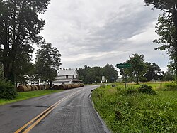
Poindexter, July 2023
USA Virginia location map.svg
Red pog.svg
Poindexter
Usa edcp location map.svg
Red pog.svg
Poindexter
Coordinates: 38°00′5.51″N78°8′40.78″W / 38.0015306°N 78.1446611°W / 38.0015306; -78.1446611
Country United States
State Virginia
County Louisa
Named after Local postman [1]
Elevation
397 ft (121 m)
Time zone UTC-5 (Eastern (EST))
  Summer (DST) UTC-4 (EDT)
ZIP code
23093
Area code 540
GNIS feature ID1477634 [2]

Poindexter is an unincorporated community in Louisa County, Virginia, United States. [2] It is located at the four-way intersection of minor Virginia State Routes 613 (Poindexter Road) and 640 (Jack Jouett Road). State Route 717 (Central Branch Road) spurs off State Route 613 nearby.

Contents

A post office and store once operated in Poindexter. [3] Citations suggest that the community is named for the postman who operated them around the 1850s. [1]

Geography

Poindexter is surrounded by farmland and private properties and small forested patches and lies at an elevation of 397 feet (121 m). [2]

Churches

Churches in the Poindexter area are:

References

  1. 1 2 Hummel, Ray O. A List of Places Included in 19th Century Virginia Directories. Richmond, Virginia: Virginia State Library, 1981.
  2. 1 2 3 "Poindexter". Geographic Names Information System . United States Geological Survey, United States Department of the Interior.
  3. "Poindexter Post Office". Geographic Names Information System . United States Geological Survey, United States Department of the Interior.
  4. "Fosters Creek Church". Geographic Names Information System . United States Geological Survey, United States Department of the Interior.
  5. 1 2 "Church History". Foster Creek Baptist Church. Retrieved July 19, 2021.
  6. "Berea Church". Geographic Names Information System . United States Geological Survey, United States Department of the Interior.